National Register of Historic Places listings in Toombs County, Georgia
This is a list of properties and districts in Toombs County, Georgia that are listed on the National Register of Historic Places (NRHP).
- This National Park Service list is complete through NPS recent listings posted January 29, 2021.[1]

Current listings
| [2] | Name on the Register | Image | Date listed[3] | Location | City or town | Description |
|---|---|---|---|---|---|---|
| 1 | Crawford W. Brazell House | .jpg.webp) Crawford W. Brazell House |
June 17, 1982 (#82002486) |
607 Jackson St. 32°12′41″N 82°24′55″W |
Vidalia | Now the Altama Museum of Art & History |
| 2 | Citizens Bank of Vidalia | 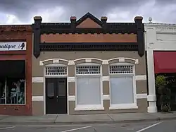 Citizens Bank of Vidalia |
January 22, 1992 (#91002004) |
117 SE. Main St. 32°13′06″N 82°24′42″W |
Vidalia | Also part of the Vidalia Commercial Historic District |
| 3 | Robert and Missouri Garbutt House | 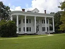 Robert and Missouri Garbutt House |
December 28, 2000 (#00001564) |
700 W. Liberty St. (corner with Bulldog Rd.) 32°12′04″N 82°19′48″W |
Lyons | |
| 4 | Leader-Rosansky House | .jpg.webp) Leader-Rosansky House |
June 20, 1995 (#95000735) |
403 Jackson St. 32°12′52″N 82°24′50″W |
Vidalia | |
| 5 | Lyons Woman's Club House | 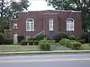 Lyons Woman's Club House |
May 2, 1985 (#85000940) |
East Liberty St. 32°12′10″N 82°19′13″W |
Lyons | |
| 6 | McLemore-Sharpe Farmstead | 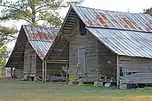 McLemore-Sharpe Farmstead |
August 19, 1982 (#82002487) |
SW of Vidalia on GA 130 32°11′36″N 82°26′04″W |
Vidalia | |
| 7 | Peterson-Wilbanks House | .jpg.webp) Peterson-Wilbanks House |
March 22, 1990 (#90000491) |
404 Jackson St. 32°12′50″N 82°24′47″W |
Vidalia | |
| 8 | Jim Smith House | 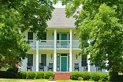 Jim Smith House |
August 31, 1989 (#89001213) |
Rt. 3/Toombs County Rd. 18 32°01′03″N 82°15′09″W |
Lyons | |
| 9 | Vidalia Commercial Historic District | 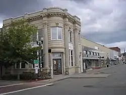 Vidalia Commercial Historic District |
September 27, 1996 (#96001020) |
Roughly bounded by Meadow, Jackson, Pine, and Thompson Sts. 32°13′21″N 82°24′47″W |
Vidalia |
References
- "National Register of Historic Places: Weekly List Actions". National Park Service, United States Department of the Interior. Retrieved on January 29, 2021.
- Numbers represent an alphabetical ordering by significant words. Various colorings, defined here, differentiate National Historic Landmarks and historic districts from other NRHP buildings, structures, sites or objects.
- The eight-digit number below each date is the number assigned to each location in the National Register Information System database, which can be viewed by clicking the number.
| Wikimedia Commons has media related to National Register of Historic Places in Toombs County, Georgia. |
This article is issued from Wikipedia. The text is licensed under Creative Commons - Attribution - Sharealike. Additional terms may apply for the media files.