National Register of Historic Places listings in Decatur County, Georgia
This is a list of properties and districts in Decatur County, Georgia that are listed on the National Register of Historic Places (NRHP).
- This National Park Service list is complete through NPS recent listings posted February 5, 2021.[1]

Current listings
| [2] | Name on the Register | Image | Date listed[3] | Location | City or town | Description |
|---|---|---|---|---|---|---|
| 1 | Allen Mercantile Company | 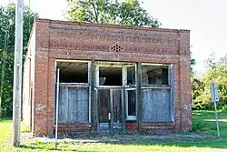 Allen Mercantile Company |
December 31, 2002 (#02001632) |
102 Main St. 30°52′32″N 84°25′54″W |
Climax | |
| 2 | Bainbridge Commercial Historic District |  Bainbridge Commercial Historic District |
November 6, 1987 (#87001908) |
Roughly bounded by Water, Clark, Troupe, West, Broughton, & Crawford Sts. 30°54′21″N 84°34′32″W |
Bainbridge | |
| 3 | Bainbridge Residential Historic District | 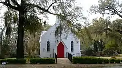 Bainbridge Residential Historic District |
November 5, 1987 (#87001907) |
Roughly bounded by Calhoun, Scott, Evans, College, & Washington Sts. 30°54′14″N 84°34′26″W |
Bainbridge | |
| 4 | Brinson Family Historic District | October 2, 1986 (#86002677) |
Bainbridge, Wainhurst and Leon Sts. 30°58′35″N 84°44′13″W |
Brinson | ||
| 5 | J. W. Callahan House | %252C_Bainbridge.JPG.webp) J. W. Callahan House |
December 12, 1976 (#76000616) |
200 Evans St. 30°54′07″N 84°34′32″W |
Bainbridge | |
| 6 | Curry Hill Plantation | 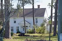 Curry Hill Plantation |
January 29, 1973 (#73000620) |
6 mi. E of Bainbridge on U.S. 84 30°52′58″N 84°27′57″W |
Bainbridge | |
| 7 | Decatur County Courthouse | .JPG.webp) Decatur County Courthouse |
September 18, 1980 (#80001011) |
West and Water Sts. 30°54′24″N 84°34′37″W |
Bainbridge | |
| 8 | First African Missionary Baptist Church | %252C_Bainbridge.JPG.webp) First African Missionary Baptist Church |
January 28, 2002 (#01001535) |
515 Webster St. 30°54′36″N 84°34′22″W |
Bainbridge |
References
- "National Register of Historic Places: Weekly List Actions". National Park Service, United States Department of the Interior. Retrieved on February 5, 2021.
- Numbers represent an alphabetical ordering by significant words. Various colorings, defined here, differentiate National Historic Landmarks and historic districts from other NRHP buildings, structures, sites or objects.
- The eight-digit number below each date is the number assigned to each location in the National Register Information System database, which can be viewed by clicking the number.
| Wikimedia Commons has media related to National Register of Historic Places in Decatur County, Georgia. |
| Topics | |
|---|---|
| Lists by state |
|
| Lists by insular areas | |
| Lists by associated state | |
| Other areas | |
| Related | |
| |
This article is issued from Wikipedia. The text is licensed under Creative Commons - Attribution - Sharealike. Additional terms may apply for the media files.