National Register of Historic Places listings in Macon County, Georgia
This is a list of properties and districts in Macon County, Georgia that are listed on the National Register of Historic Places (NRHP).
- This National Park Service list is complete through NPS recent listings posted January 29, 2021.[1]

Current listings
| [2] | Name on the Register | Image | Date listed[3] | Location | City or town | Description |
|---|---|---|---|---|---|---|
| 1 | Alma Fruit Farm | November 25, 1980 (#80004446) |
GA 49W 32°26′13″N 84°00′04″W |
Marshallville | ||
| 2 | Andersonville National Historic Site | 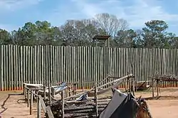 Andersonville National Historic Site |
October 16, 1970 (#70000070) |
1 mi. E of Andersonville on GA 49 32°11′41″N 84°07′44″W |
Andersonville | administered by the National Park Service |
| 3 | Billy Place | November 25, 1980 (#80004444) |
Rt. 1 32°25′10″N 83°57′44″W |
Marshallville | ||
| 4 | DeVaughn-Lewis House | May 2, 1985 (#85000937) |
510 S. Dooly St. 32°17′38″N 84°01′53″W |
Montezuma | ||
| 5 | East Main Street Residential District | November 25, 1980 (#80004454) |
E. Main St. 32°27′18″N 83°56′12″W |
Marshallville | ||
| 6 | William Hamilton Felton House | November 25, 1980 (#80004447) |
McCaskill St. 32°26′50″N 83°57′02″W |
Marshallville | ||
| 7 | Wilkes Knob Plantation | November 25, 1980 (#80004451) |
Rt. 1 32°28′20″N 83°52′48″W |
Marshallville | ||
| 8 | Lamson-Richardson School | May 18, 1981 (#81000697) |
Railroad St. 32°26′49″N 83°56′40″W |
Marshallville | ||
| 9 | Macon County Courthouse |  Macon County Courthouse |
September 18, 1980 (#80001113) |
Courthouse Sq. 32°17′36″N 84°03′36″W |
Oglethorpe | |
| 10 | Marshallville Commercial District | November 25, 1980 (#80004452) |
Main St. 32°27′23″N 83°55′24″W |
Marshallville | ||
| 11 | Massee Lane | November 25, 1980 (#80004450) |
Rt. 1 32°29′17″N 83°56′09″W |
Marshallville | ||
| 12 | Montezuma Depot | .JPG.webp) Montezuma Depot |
June 12, 1980 (#80001112) |
S. Dooly St. 32°18′02″N 84°01′46″W |
Montezuma | |
| 13 | Montezuma Historic District | 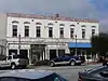 Montezuma Historic District |
October 13, 2003 (#03001017) |
Roughly centered along N. and S. Dooly St. 32°18′11″N 84°01′47″W |
Montezuma | |
| 14 | Thronateeska | November 25, 1980 (#80004445) |
Rt. 1 32°25′14″N 84°00′59″W |
Marshallville | Seems to be gone in recent satellite views | |
| 15 | West Main Street Residential District | November 25, 1980 (#80004453) |
W. Main St. 32°27′21″N 83°56′59″W |
Marshallville | ||
| 16 | Willow Lake | November 25, 1980 (#80004449) |
Rt. 1 32°28′36″N 83°53′25″W |
Marshallville |
References
- "National Register of Historic Places: Weekly List Actions". National Park Service, United States Department of the Interior. Retrieved on January 29, 2021.
- Numbers represent an alphabetical ordering by significant words. Various colorings, defined here, differentiate National Historic Landmarks and historic districts from other NRHP buildings, structures, sites or objects.
- The eight-digit number below each date is the number assigned to each location in the National Register Information System database, which can be viewed by clicking the number.
| Wikimedia Commons has media related to National Register of Historic Places in Macon County, Georgia. |
| Topics | |
|---|---|
| Lists by state |
|
| Lists by insular areas | |
| Lists by associated state | |
| Other areas | |
| Related | |
| |
This article is issued from Wikipedia. The text is licensed under Creative Commons - Attribution - Sharealike. Additional terms may apply for the media files.