National Register of Historic Places listings in Camden County, Georgia
This is a list of properties and districts in Camden County, Georgia that are listed on the National Register of Historic Places (NRHP).
- This National Park Service list is complete through NPS recent listings posted February 5, 2021.[1]

Current listings
| [2] | Name on the Register | Image | Date listed[3] | Location | City or town | Description |
|---|---|---|---|---|---|---|
| 1 | Camden County Courthouse | %252C_Woodbine%252C_GA%252C_US.jpg.webp) Camden County Courthouse |
September 18, 1980 (#80000983) |
4th and Camden Aves. 30°58′06″N 81°43′14″W |
Woodbine | |
| 2 | Crooked River Site (9CAM118) | 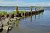 Crooked River Site (9CAM118) |
December 23, 1985 (#85003179) |
Address Restricted. |
St. Marys | Is in the extreme northeastern part of Crooked River State Park[4] |
| 3 | Duck House | February 13, 1984 (#84000938) |
Cumberland Island 30°50′50″N 81°25′51″W |
St. Marys | ||
| 4 | Dungeness Historic District | 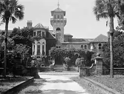 Dungeness Historic District |
February 13, 1984 (#84000920) |
Address Restricted (on Cumberland Island) |
St. Marys | |
| 5 | Greyfield | 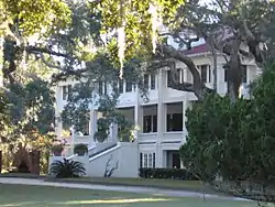 Greyfield |
July 24, 2003 (#03000675) |
Cumberland Island 30°46′47″N 81°28′07″W |
||
| 6 | High Point-Half Moon Bluff Historic District | December 22, 1978 (#78000265) |
NE of St. Marys on Cumberland Island 30°55′14″N 81°25′56″W |
St. Marys | ||
| 7 | Kingsland Commercial Historic District |  Kingsland Commercial Historic District |
March 17, 1994 (#94000186) |
Area surrounding S. Lee St. (US 17), between King and William Sts. 30°47′58″N 81°41′25″W |
Kingsland | |
| 8 | Little Cumberland Island Lighthouse | 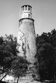 Little Cumberland Island Lighthouse |
August 28, 1989 (#89001407) |
N end of Little Cumberland Island 30°58′34″N 81°24′47″W |
St. Marys | |
| 9 | Main Road | 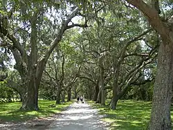 Main Road |
February 13, 1984 (#84000941) |
Cumberland Island 30°49′45″N 81°27′26″W |
St. Marys | |
| 10 | John Houstoun McIntosh Sugarhouse | 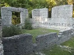 John Houstoun McIntosh Sugarhouse |
April 2, 1992 (#92000167) |
Ga. Spur 40, 6 mi. N of St. Marys, access is from Charlie Smith Hwy. (at 30.79310°N 81.57712°W) 30°47′36″N 81°34′43″W |
St. Marys | |
| 11 | Orange Hall | 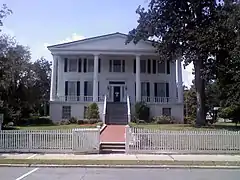 Orange Hall |
May 7, 1973 (#73000613) |
311 Osborne St. 30°43′28″N 81°32′53″W |
St. Marys | |
| 12 | Plum Orchard Historic District | 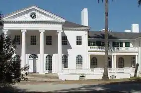 Plum Orchard Historic District |
November 23, 1984 (#84000258) |
Address Restricted (on Cumberland Island) |
St. Marys | |
| 13 | Rayfield Archeological District | February 13, 1984 (#84000924) |
Address Restricted |
St. Marys | On Cumberland Island | |
| 14 | St. Marys Historic District | 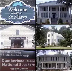 St. Marys Historic District |
May 13, 1976 (#76000609) |
Roughly bounded by Waterfront Rd., Norris, Alexander, and Oak Grove Cemetery 30°43′24″N 81°32′53″W |
St. Marys | |
| 15 | Stafford Plantation | Stafford Plantation |
November 23, 1984 (#84000265) |
Address Restricted (on Cumberland Island) |
St. Marys | The only surviving antebellum-era structures are "the chimneys," slave cabin ruins. |
| 16 | Table Point Archeological District | November 23, 1984 (#84000260) |
Address Restricted |
St. Marys | On Cumberland Island[5] | |
| 17 | Woodbine Historic District | 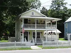 Woodbine Historic District |
May 12, 1999 (#99000553) |
Jct. of Bedell Ave. (US 17) and 3rd and 4th Sts. and the central business district 30°58′04″N 81°43′27″W |
Woodbine |
References
- "National Register of Historic Places: Weekly List Actions". National Park Service, United States Department of the Interior. Retrieved on February 5, 2021.
- Numbers represent an alphabetical ordering by significant words. Various colorings, defined here, differentiate National Historic Landmarks and historic districts from other NRHP buildings, structures, sites or objects.
- The eight-digit number below each date is the number assigned to each location in the National Register Information System database, which can be viewed by clicking the number.
- paper abstract
- NPS
| Wikimedia Commons has media related to National Register of Historic Places in Camden County, Georgia. |
| Topics | |
|---|---|
| Lists by state |
|
| Lists by insular areas | |
| Lists by associated state | |
| Other areas | |
| Related | |
| |
This article is issued from Wikipedia. The text is licensed under Creative Commons - Attribution - Sharealike. Additional terms may apply for the media files.