National Register of Historic Places listings in Oconee County, Georgia
This is a list of properties and districts in Oconee County, Georgia that are listed on the National Register of Historic Places (NRHP).
- This National Park Service list is complete through NPS recent listings posted February 5, 2021.[1]

Current listings
| [2] | Name on the Register | Image | Date listed[3] | Location | City or town | Description |
|---|---|---|---|---|---|---|
| 1 | Bishop Historic District | May 10, 1996 (#96000534) |
Roughly along Price Mill, Old Bishop Rds., and US 441 within the Bishop city limits 33°49′01″N 83°26′14″W |
Bishop | ||
| 2 | William Daniell House | 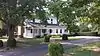 William Daniell House |
February 13, 1995 (#94001638) |
Epps Bridge Rd., 3 1/2 mi. NW of Watkinsville 33°54′19″N 83°27′13″W |
Watkinsville | |
| 3 | Durham Homeplace | March 15, 2000 (#00000194) |
1561 Watson Springs Rd. 33°45′18″N 83°19′59″W |
Watkinsville | ||
| 4 | Eagle Tavern | .jpg.webp) Eagle Tavern |
May 13, 1970 (#70000215) |
U.S. 129 33°51′50″N 83°24′23″W |
Watkinsville | |
| 5 | Elder's Mill Covered Bridge and Elder Mill | 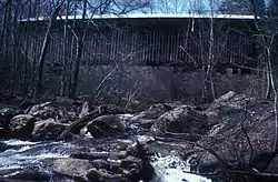 Elder's Mill Covered Bridge and Elder Mill |
May 5, 1994 (#94000389) |
4/5 mi. S of jct. of Elder Mill Rd. and GA 15 33°48′11″N 83°21′49″W |
Watkinsville | |
| 6 | Farmers and Citizens Supply Company Block | July 2, 1987 (#87001104) |
US 129 33°51′48″N 83°24′38″W |
Watkinsville | ||
| 7 | High Shoals Historic District | October 26, 2006 (#06000958) |
Centered on GA 186, and banks of the Apalachee R 33°49′06″N 83°30′32″W |
North High Shoals | ||
| 8 | Abe Jones House | 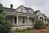 Abe Jones House |
January 28, 1994 (#93001572) |
2411 Hog Mountain Rd. 33°52′01″N 83°26′50″W |
Watkinsville | |
| 9 | South Main Street Historic District | March 26, 1979 (#79000739) |
S. Main St. and Harden Hill Rd. 33°51′30″N 83°24′30″W |
Watkinsville |
References
- "National Register of Historic Places: Weekly List Actions". National Park Service, United States Department of the Interior. Retrieved on February 5, 2021.
- Numbers represent an alphabetical ordering by significant words. Various colorings, defined here, differentiate National Historic Landmarks and historic districts from other NRHP buildings, structures, sites or objects.
- The eight-digit number below each date is the number assigned to each location in the National Register Information System database, which can be viewed by clicking the number.
| Wikimedia Commons has media related to National Register of Historic Places in Oconee County, Georgia. |
| Topics | |
|---|---|
| Lists by state |
|
| Lists by insular areas | |
| Lists by associated state | |
| Other areas | |
| Related | |
| |
This article is issued from Wikipedia. The text is licensed under Creative Commons - Attribution - Sharealike. Additional terms may apply for the media files.