National Register of Historic Places listings in Sumter County, Georgia
This is a list of properties and districts in Sumter County, Georgia that are listed on the National Register of Historic Places (NRHP).
- This National Park Service list is complete through NPS recent listings posted February 5, 2021.[1]

Current listings
| [2] | Name on the Register | Image | Date listed[3] | Location | City or town | Description |
|---|---|---|---|---|---|---|
| 1 | Americus Historic District | 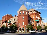 Americus Historic District |
January 1, 1976 (#76000648) |
Irregular pattern along Lee St. with extensions to Dudley St., railroad tracks, Rees Park, and Glessner St.; also E. Church St. and Oak Grove Cemetery 32°04′02″N 84°14′05″W |
Americus | Church St. and cemetery represent a boundary increase of September 3, 1979 |
| 2 | Andersonville National Historic Site | 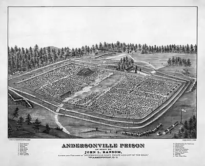 Andersonville National Historic Site |
October 16, 1970 (#70000070) |
1 mi. E of Andersonville on GA 49 32°12′23″N 84°07′24″W |
Andersonville | National Historic Site |
| 3 | Ashby Street Shotgun Row Historic District | 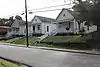 Ashby Street Shotgun Row Historic District |
June 27, 1997 (#97000620) |
207, 209, and 211 Ashby St. 32°04′38″N 84°13′39″W |
Americus | |
| 4 | Campbell Chapel AME Church | 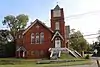 Campbell Chapel AME Church |
September 30, 1997 (#97001195) |
429 N. Jackson St. 32°04′38″N 84°14′01″W |
Americus | |
| 5 | Dismuke Storehouse | March 7, 1996 (#96000247) |
505 N. Lee St. 32°04′38″N 84°13′56″W |
Americus | ||
| 6 | Guerry-Mitchell House | June 16, 1983 (#83000242) |
723 McGarrah St. 32°04′47″N 84°14′16″W |
Americus | ||
| 7 | Jimmy Carter National Historic Site | 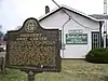 Jimmy Carter National Historic Site |
December 23, 1987 (#01000272) |
300 N. Bond St. 32°01′49″N 84°25′06″W |
Plains | administered by the National Park Service |
| 8 | Liberty Hall | 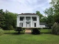 Liberty Hall |
November 25, 1980 (#80001236) |
SE of Americus on S. Lee St. 31°57′02″N 84°12′01″W |
Americus | |
| 9 | Lustron House at 547 Oak Avenue | March 18, 1996 (#96000209) |
547 Oak Ave. 32°03′48″N 84°14′07″W |
Americus | ||
| 10 | Newman McBain House | February 8, 1980 (#80001237) |
S of Americus on U.S. 19 32°02′33″N 84°15′13″W |
Americus | ||
| 11 | Morgan Farm | February 26, 1998 (#98000145) |
770 Old Dawson Rd. 31°59′41″N 84°16′56″W |
Smithville | ||
| 12 | New Corinth Baptist Church | August 10, 1998 (#98000928) |
1178 Hooks Mill Rd. 32°03′09″N 84°01′21″W |
Americus | ||
| 13 | Plains Historic District |  Plains Historic District |
June 28, 1984 (#84001220) |
Roughly bounded by Buena Vista Rd., Hospital, Clark, Main, Thomas, Paschal, and Bond Sts. 32°02′13″N 84°23′41″W |
Plains | |
| 14 | Teel-Crawford-Gaston Plantation | October 27, 2004 (#04001188) |
2154 GA 30 W 32°08′40″N 84°23′43″W |
Americus | ||
| 15 | Third District A & M School-Georgia Southwestern College Historic District | September 27, 2007 (#07001002) |
800 Wheatley St. 32°03′28″N 84°13′09″W |
Americus | ||
| 16 | Webb Family Farm |  Webb Family Farm |
September 5, 1985 (#85001968) |
US 19 31°56′44″N 84°15′24″W |
Sumter | Location of the main house - more to the south |
References
- "National Register of Historic Places: Weekly List Actions". National Park Service, United States Department of the Interior. Retrieved on February 5, 2021.
- Numbers represent an alphabetical ordering by significant words. Various colorings, defined here, differentiate National Historic Landmarks and historic districts from other NRHP buildings, structures, sites or objects.
- The eight-digit number below each date is the number assigned to each location in the National Register Information System database, which can be viewed by clicking the number.
| Wikimedia Commons has media related to National Register of Historic Places in Sumter County, Georgia. |
| Topics | |
|---|---|
| Lists by state |
|
| Lists by insular areas | |
| Lists by associated state | |
| Other areas | |
| Related | |
| |
This article is issued from Wikipedia. The text is licensed under Creative Commons - Attribution - Sharealike. Additional terms may apply for the media files.