National Register of Historic Places listings in Carroll County, Georgia
This is a list of properties and districts in Carroll County, Georgia that are listed on the National Register of Historic Places (NRHP).
- This National Park Service list is complete through NPS recent listings posted January 29, 2021.[1]

Current listings
| [2] | Name on the Register | Image | Date listed[3] | Location | City or town | Description |
|---|---|---|---|---|---|---|
| 1 | Bonner-Sharp-Gunn House | 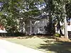 Bonner-Sharp-Gunn House |
May 13, 1970 (#70000198) |
University of West Georgia campus 33°34′17″N 85°05′53″W |
Carrollton | |
| 2 | Bowdon Historic District |  Bowdon Historic District |
December 8, 2009 (#09001056) |
Roughly centered along Georgia State Route 166 and Georgia State Route 100 33°32′17″N 85°15′12″W |
Bowdon | |
| 3 | Burns Quarry | August 29, 1977 (#77001539) |
Address Restricted |
Carrollton | ||
| 4 | Carroll County Courthouse | 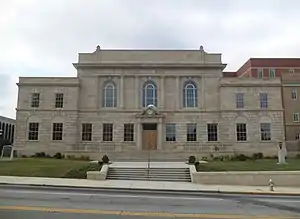 Carroll County Courthouse |
September 18, 1980 (#80000985) |
Newnan and Dixie Sts. 33°34′46″N 85°04′22″W |
Carrollton | Built in 1928 |
| 5 | Carrollton Downtown Historic District | 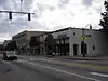 Carrollton Downtown Historic District |
May 1, 2007 (#07000378) |
Roughly around downtown sq. and is bounded by Johnson Ave., White St., Mill St. and Barnes St. 33°34′48″N 85°04′26″W |
Carrollton | |
| 6 | Dorough Round Barn and Farm | 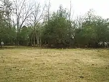 Dorough Round Barn and Farm |
January 20, 1980 (#80000986) |
N of Hickory Level on Villa Rica Rd. 33°41′07″N 84°59′18″W |
Hickory Level | |
| 7 | Eric Vernon Folds House | 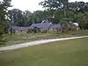 Eric Vernon Folds House |
August 24, 2005 (#05000902) |
1575 GA 16 33°38′10″N 85°02′16″W |
Carrollton | |
| 8 | Lawler Hosiery Mill | 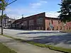 Lawler Hosiery Mill |
January 26, 2005 (#04001558) |
301 Bradley St. 33°34′40″N 85°04′34″W |
Carrollton | |
| 9 | Dr. James L. Lovvorn House | .JPG.webp) Dr. James L. Lovvorn House |
May 19, 1988 (#88000595) |
113 E. College St. 33°32′18″N 85°15′11″W |
Bowdon | |
| 10 | Mandeville Mills and Mill Village Historic District | 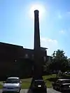 Mandeville Mills and Mill Village Historic District |
April 19, 2006 (#06000287) |
Roughly centered on Aycock, Lovvorn, and Burson Sts. 33°34′46″N 85°05′19″W |
Carrollton | |
| 11 | McDaniel-Huie Place | .JPG.webp) McDaniel-Huie Place |
May 24, 1990 (#90000803) |
1238 SR 166 W. 33°32′36″N 85°16′35″W |
Bowdon | |
| 12 | North Villa Rica Commercial Historic District | 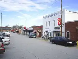 North Villa Rica Commercial Historic District |
December 31, 2002 (#02001635) |
Roughly bounded by Southern Railroad, North Ave., and East Gordon and West Church Sts. 33°43′56″N 84°55′30″W |
Villa Rica | |
| 13 | South Carrollton Residential Historic District | .JPG.webp) South Carrollton Residential Historic District |
June 28, 1984 (#84000947) |
Roughly bounded by RR tracks, Harmon and West Aves., Bradley, Mill and Garrett Sts., Tillman and Hill Drs. 33°34′32″N 85°04′20″W |
Carrollton | |
| 14 | U.S. Post Office | 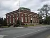 U.S. Post Office |
April 18, 1983 (#83000185) |
402 Newnan St. 33°34′48″N 85°04′21″W |
Carrollton | |
| 15 | Veal School | Veal School |
December 22, 2005 (#05001427) |
2753 Old Columbus Rd. 33°26′08″N 85°13′55″W |
Roopville | |
| 16 | Whitesburg Baptist Church | 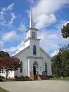 Whitesburg Baptist Church |
October 22, 2002 (#02001220) |
662 Main St. 33°29′35″N 84°54′50″W |
Whitesburg | |
| 17 | Williams Family Farm | 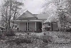 Williams Family Farm |
March 25, 2005 (#05000193) |
55 Goldworth Rd. 33°42′12″N 84°56′36″W |
Villa Rica |
References
- "National Register of Historic Places: Weekly List Actions". National Park Service, United States Department of the Interior. Retrieved on January 29, 2021.
- Numbers represent an alphabetical ordering by significant words. Various colorings, defined here, differentiate National Historic Landmarks and historic districts from other NRHP buildings, structures, sites or objects.
- The eight-digit number below each date is the number assigned to each location in the National Register Information System database, which can be viewed by clicking the number.
| Wikimedia Commons has media related to National Register of Historic Places in Carroll County, Georgia. |
This article is issued from Wikipedia. The text is licensed under Creative Commons - Attribution - Sharealike. Additional terms may apply for the media files.