National Register of Historic Places listings in Habersham County, Georgia
This is a list of properties and districts in Habersham County, Georgia that are listed on the National Register of Historic Places (NRHP).
- This National Park Service list is complete through NPS recent listings posted January 29, 2021.[1]

Current listings
| [2] | Name on the Register | Image | Date listed[3] | Location | City or town | Description |
|---|---|---|---|---|---|---|
| 1 | Acoa | June 22, 1982 (#82002446) |
Mathis Rd. 34°39′09″N 83°28′16″W |
Hollywood | ||
| 2 | Henry Asbury House | 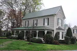 Henry Asbury House |
August 18, 1982 (#82002425) |
211 E. Waters St. 34°37′01″N 83°31′26″W |
Clarkesville | |
| 3 | Baron-York Building | 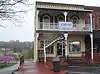 Baron-York Building |
August 18, 1982 (#82002426) |
714 N. Washington St. 34°36′56″N 83°31′34″W |
Clarkesville | |
| 4 | Chenocetah Fire Tower | 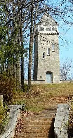 Chenocetah Fire Tower |
June 11, 1984 (#84001110) |
Chenocetah Mountain 34°30′08″N 83°30′25″W |
Cornelia | |
| 5 | Church Furniture Store | August 18, 1982 (#82002427) |
N. Washington St. 34°36′53″N 83°31′32″W |
Clarkesville | North corner of Washington and Green | |
| 6 | Clarkesville Garage | August 18, 1982 (#82002429) |
304 N. Washington St. 34°36′52″N 83°31′32″W |
Clarkesville | SE corner of Washington and Green | |
| 7 | Cornelius Church House | August 18, 1982 (#82002428) |
304 N. Washington St. 34°36′53″N 83°31′30″W |
Clarkesville | ||
| 8 | Cornelia Community House |  Cornelia Community House |
June 21, 1982 (#82002445) |
U.S. 123 at LaVista Lane 34°30′47″N 83°31′08″W |
Cornelia | |
| 9 | Daes Chapel Methodist Church | August 18, 1982 (#82002430) |
N. Washington St. 34°36′56″N 83°31′41″W |
Clarkesville | ||
| 10 | Demorest Commercial Historic District | October 16, 1989 (#89001713) |
Georgia St. and Central Ave. 34°33′54″N 83°32′43″W |
Demorest | ||
| 11 | Demorest Women's Club | 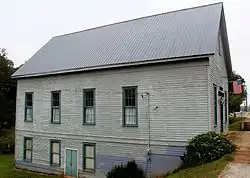 Demorest Women's Club |
December 30, 2008 (#08001247) |
1035 Central Ave. 34°33′59″N 83°32′39″W |
Demorest | |
| 12 | Furr-Lambert House | 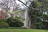 Furr-Lambert House |
August 18, 1982 (#82002431) |
223 Grant St. 34°37′06″N 83°31′27″W |
Clarkesville | |
| 13 | Glen-Ella Springs Hotel | January 4, 1990 (#89002270) |
SW of Tallulah Falls on Co. Rd. 218 34°43′12″N 83°26′54″W |
Turnerville | ||
| 14 | Grace Church | %252C_HABERSHAM_COUNTY.jpg.webp) Grace Church |
February 15, 1980 (#80001087) |
Wilson and Greene Sts. 34°36′58″N 83°31′24″W |
Clarkesville | |
| 15 | Griggs-Erwin House |  Griggs-Erwin House |
August 18, 1982 (#82002432) |
Bridge St. 34°37′02″N 83°31′37″W |
Clarkesville | |
| 16 | Haywood English Family Log House |  Haywood English Family Log House |
December 19, 1991 (#91001852) |
GA 115 W of jct. with Habersham Rd. 34°36′25″N 83°34′26″W |
Clarkesville | |
| 17 | A. P. Hill House | August 18, 1982 (#82002433) |
N. Washington St. 34°36′48″N 83°31′30″W |
Clarkesville | ||
| 18 | Irvin General Merchandise Store | July 26, 1984 (#84001113) |
Irvin St. 34°30′40″N 83°31′40″W |
Cornelia | ||
| 19 | Jackson Building |  Jackson Building |
August 18, 1982 (#82002434) |
710 N. Washington St. 34°36′56″N 83°31′33″W |
Clarkesville | |
| 20 | Jackson Pharmacy |  Jackson Pharmacy |
August 18, 1982 (#82002435) |
712 N. Washington St. 34°36′56″N 83°31′34″W |
Clarkesville | |
| 21 | Lawton Place | January 8, 2009 (#08001282) |
136 7th St. 34°31′01″N 83°29′58″W |
Mount Airy | ||
| 22 | J. A. Lewis House |  J. A. Lewis House |
August 18, 1982 (#82002436) |
N. Washington St. 34°36′48″N 83°31′27″W |
Clarkesville | |
| 23 | Loudermilk Boarding House |  Loudermilk Boarding House |
February 9, 2001 (#01000079) |
271 Foreacre St. 34°30′42″N 83°31′28″W |
Cornelia | |
| 24 | Market Building | August 18, 1982 (#82002437) |
N. Washington St. 34°36′56″N 83°31′41″W |
Clarkesville | ||
| 25 | Mauldin House |  Mauldin House |
August 18, 1982 (#82002438) |
102 E. Water St. 34°36′56″N 83°31′31″W |
Clarkesville | |
| 26 | Robert McMillan House | August 18, 1982 (#82002439) |
Allen Lane 34°36′20″N 83°31′08″W |
Clarkesville | ||
| 27 | McMillan-Garrison House | August 18, 1982 (#82002440) |
403 S. Washington St. 34°36′16″N 83°31′11″W |
Clarkesville | ||
| 28 | Olgetree Farm | July 9, 1997 (#97000753) |
Jct. of Pea Ridge Rd. and Paradise Park Rd. 34°32′21″N 83°35′44″W |
View | ||
| 29 | Porter-York House | 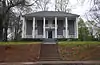 Porter-York House |
August 18, 1982 (#82002441) |
Bridge St. 34°37′03″N 83°31′38″W |
Clarkesville | |
| 30 | Pyle-Davis House |  Pyle-Davis House |
June 23, 2003 (#03000537) |
202 Massachusetts Bvd. 34°33′53″N 83°32′34″W |
Demorest | |
| 31 | Reeves Building | August 18, 1982 (#82002442) |
N. Washington St. 34°36′53″N 83°31′37″W |
Clarkesville | ||
| 32 | South Washington Street Historic District | August 18, 1982 (#82002443) |
S. Washington St. between Laurel Dr. and Spring St. 34°36′26″N 83°31′17″W |
Clarkesville | ||
| 33 | Tallulah Falls School |  Tallulah Falls School |
January 30, 1992 (#91002026) |
Jct. of US 441 and Tallulah School Rd. 34°43′54″N 83°23′36″W |
Tallulah Falls | |
| 34 | Washington-Jefferson Street Historic District | August 18, 1982 (#82002444) |
Washington, Jefferson, and Wilson Sts. between Green St. and Laurel Dr. 34°36′49″N 83°31′21″W |
Clarkesville | ||
| 35 | Woodlands and Blythewood | December 30, 1975 (#75002121) |
3 mi. N of Clarkesville off U.S. 441 34°39′00″N 83°29′54″W |
Clarkesville |
References
- "National Register of Historic Places: Weekly List Actions". National Park Service, United States Department of the Interior. Retrieved on January 29, 2021.
- Numbers represent an alphabetical ordering by significant words. Various colorings, defined here, differentiate National Historic Landmarks and historic districts from other NRHP buildings, structures, sites or objects.
- The eight-digit number below each date is the number assigned to each location in the National Register Information System database, which can be viewed by clicking the number.
| Wikimedia Commons has media related to National Register of Historic Places in Habersham County, Georgia. |
| Topics | |
|---|---|
| Lists by state |
|
| Lists by insular areas | |
| Lists by associated state | |
| Other areas | |
| Related | |
| |
This article is issued from Wikipedia. The text is licensed under Creative Commons - Attribution - Sharealike. Additional terms may apply for the media files.