Pusad
Pusad is a city in the Yavatmal district located in Vidarbha region of Maharashtra state of India. It is named after the Pus river. Its ancient name was 'Pushpawanti'.
Pusad | |
|---|---|
City | |
 Pusad Location in Maharashtra, India | |
| Coordinates: 19.87°N 77.78°E | |
| Country | India |
| State | Maharashtra |
| District | Yavatmal |
| Government | |
| • Type | Municipal Council |
| Area | |
| • Total | 30 km2 (10 sq mi) |
| Elevation | 315 m (1,033 ft) |
| Population (2011)[1] | |
| • Total | 123,446 |
| • Density | 4,100/km2 (11,000/sq mi) |
| Demonym(s) | Pusadkar, Pusadian |
| Language | |
| • Official | Marathi[2] |
| Time zone | UTC+5:30 (IST) |
| PIN | 445204 |
| Telephone code | 07233 |
| Vehicle registration | MH 29 (Yavatmal district) 3861900041215 |
History
Early era
.JPG.webp)
Pusad is a tribal area,[3] of mostly Banjaras. Banjara of Pusad area have an oral tradition of their migration from Rajasthan toward central and south India from 12th century after the defeat and death of Prithviraj Chauhan by Muhammad Ghouri in the 1191 Battle of Tarain in present-day Haryana, a narrative which also coincides with the oral traditions of Romani gypsies of Europe who also recall 12th century Islamic invasion of India as the cause of their migration.[4]
Medieval era
Two temples in 13th century hemadpanti architecture, ruins of several temples, a fine tank exist in Pusad area as per the ASI report of 1874 CE.[5]
During 16 to 20th century Pusad was part of Berar Province which kept changing hands between Maratha Peshwas and Mughals. During 1760 and 1795 this area was with Maratha Bhonsla rajas of Nagpur kingdom. Marathas ceded these to British after Wellesley's victories at Assaye and Argaon (1803), who in turn handed these over to Nizam-ul-Mulk of Hyderabad State in 1804. After this Pindari and Bhil raiders too stopped their harassing raids in this area. Nizam was initially a viceroy of Hydrabad province of Mughal Empire, from 1724 CE he ruled this area independently until he came under British protectorate, after 1857 he gradually became a princely state of the British raj.
British era
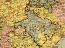
During British raj's Great Trigonometrical Survey (1802-1871), to install and maintain measuring marker stones, the Bittergaon and Sukli villages in Pusad area were visited regularly including in 1868 and 1873.[6] Washim to Pusad road through Penganga reserve was constructed around 1878.[7]
In 1853, the administration of the Berar province was assigned to the British East India Company by the Nizam following a treaty. It was divided into two districts each headed by a deputy commissioner, South Berar with its headquarters at Hingoli, and North Berar with its headquarters at Buldana. After the Indian Rebellion of 1857, Hingoli and its adjoining areas [including Pusad] were restored to the Nizam and the province was reconstituted into two districts, East Berar with its headquarters at Amravati, and West Berar with its headquarters at Akola.[8] In 1903 Berar Province became the Berar Division of Central Provinces. In 1936 these were renamed as Central Provinces and Berar.
Independent India
In 1950 when the Constitution of India came into effect, Pusad as part of the Central Provinces & Berar was merged with the newly formed state of Madhya Pradesh. In 1956, under pressure from Marathi Irredentists, the Berar and Nagpur divisions were transferred to Bombay state. In 1960, the Bombay State was partitioned into Maharashtra & Gujarat.[9] There is an ongoing Vidarbha movement to demand statehood for Vidarbha region,[10][11] as well as a separate movement to demand upgrade of Pusad's status from taluk to district.[12][13][14]
Vasantrao Naik, a grassroots Banjara leader, who was born in Gavli village of Pusad remains the longest serving Chief Minister of Maharashtra from 1963 to 1975.[15]
Geography
Topography
Just north of Pusad hills is the Buldhana-Yavatmal plateau, itself part of the bigger deccan plateau, extends from Penganga valley of Pusad region in south, to the Purna valley of Ajanta range of Marathwada in north, and to Wardha valley in the east. It covers the southern parts of districts of Akola, Buldhana and Yavatmal. Highest elevation of 600–900 m is found in Buldhana and Chikhuli, 450–600 m in south around Pusad, 300–450 m sloping escarpment (steep cliff) towards Purna and Wardha river valleys in north and east respectively. The edges and interior of this plateau are jagged and littered with series of hills and valleys. Hills are mostly "flat topped" (eroded former larger plateau) with sharp drops, trappean in structure, made of basalt, gradually sloping in the west but uneven in the east. Slopes are steep, dry, without many plants or trees. Further north of Ajanta range is "Amravati plateau" which extends till Gawilghur hill range.[16]
Hydology
The town is located on the south and western banks of the "Pus river". The Pus river flows through Pusad taluka, the Arunavati River and Adan River through Darwha taluka.[17] Murray Leaf explains that the "Pus valley" lies in a wide but isolated upland valley in the tribal area which has small towns and very few highways as most of the area is covered with teak and sal forests which are illegally felled by the poachers.[3] Pus river originates in Ajanta range near Washim town. It flows through Pusad, confluences with Penganga River[18] near Mahur in Nanded district of Maharashtra, Penganga River in turn flows into Wardha River,[18] which in turn flows into Pranhita River,[18] and Pranhita in turn flows in to Godavari river[18] which finally end in the Bay of Bengal just east of Rajahmundry in the state of Andhra Pradesh. All these rivers drain the Deccan Plateau in the south-easterly and easterly directions along the general slope of the plateau.[19]
Climate
Pusad's climate is extreme, with temperatures ranging as high as 49 °C (120 °F) during summer to as low as 5 °C (41 °F) during winter. This temperature range is a result of the "Basket Effect" (i.e. high-altitude hillside effect), as Pusad is surrounded by hills.
| Climate data for Pusad (1981–2010, extremes 1960–2008) | |||||||||||||
|---|---|---|---|---|---|---|---|---|---|---|---|---|---|
| Month | Jan | Feb | Mar | Apr | May | Jun | Jul | Aug | Sep | Oct | Nov | Dec | Year |
| Record high °C (°F) | 35.2 (95.4) |
40.4 (104.7) |
43.7 (110.7) |
46.4 (115.5) |
47.5 (117.5) |
47.6 (117.7) |
41.5 (106.7) |
38.0 (100.4) |
39.0 (102.2) |
39.0 (102.2) |
37.0 (98.6) |
39.0 (102.2) |
47.6 (117.7) |
| Average high °C (°F) | 30.6 (87.1) |
33.3 (91.9) |
37.8 (100.0) |
41.3 (106.3) |
42.9 (109.2) |
37.8 (100.0) |
32.6 (90.7) |
30.9 (87.6) |
32.8 (91.0) |
33.2 (91.8) |
31.3 (88.3) |
30.1 (86.2) |
34.6 (94.3) |
| Average low °C (°F) | 13.0 (55.4) |
14.8 (58.6) |
19.1 (66.4) |
24.0 (75.2) |
28.0 (82.4) |
25.9 (78.6) |
24.0 (75.2) |
23.2 (73.8) |
22.9 (73.2) |
19.8 (67.6) |
15.5 (59.9) |
11.9 (53.4) |
20.2 (68.4) |
| Record low °C (°F) | 2.7 (36.9) |
5.4 (41.7) |
10.4 (50.7) |
13.6 (56.5) |
19.1 (66.4) |
20.0 (68.0) |
18.1 (64.6) |
19.0 (66.2) |
16.6 (61.9) |
11.2 (52.2) |
5.7 (42.3) |
4.5 (40.1) |
2.7 (36.9) |
| Average rainfall mm (inches) | 15.7 (0.62) |
2.7 (0.11) |
10.6 (0.42) |
7.8 (0.31) |
11.2 (0.44) |
190.1 (7.48) |
221.0 (8.70) |
251.6 (9.91) |
146.9 (5.78) |
88.1 (3.47) |
21.2 (0.83) |
10.4 (0.41) |
957.3 (37.69) |
| Average rainy days | 0.8 | 0.4 | 0.8 | 0.8 | 1.8 | 9.1 | 11.9 | 11.3 | 7.0 | 4.0 | 1.3 | 0.6 | 49.7 |
| Average relative humidity (%) (at 17:30 IST) | 42 | 33 | 30 | 27 | 24 | 49 | 66 | 71 | 64 | 50 | 46 | 43 | 46 |
| Source: India Meteorological Department[20][21] | |||||||||||||
Demographics
Population
As of 2011 Indian Census, Pusad had a total population of 123,446, of which 37,366 were males and 35,680 were females. The population within the age group of 0 to 6 years was 8,673. The total number of literates in Pusad was 58,794, which constituted 80.5% of the population with male literacy of 83.6% and female literacy of 77.2%. The effective literacy rate of 7+ population of Pusad was 91.3%, of which the male literacy rate was 95.5% and the female literacy rate was 87.0%. The Scheduled Castes and Scheduled Tribes population was 10,194 and 3,453 respectively. Pusad had 14905 households in 2011.[1]
Banjaras of Pusad
Banjaras are the main tribal group of Pusad taluka, among them, Rathod and Jadhav Banjaras are most numerous. Charan Banjaras, also called Gormati Banjaram, in Pusad taluk belong to both Bada Rathod and Chota Rathode clans. Main subclans among Bada Rathod are Khola, Ratla, Khatrot, Gedavat, Raslinya, and Dedavat. The main subclans among Chota Rathod are Meghwat, Ghegawat, Ralsot, Ramawat, Khelkhawat, Manlot, Harawat, Tolawat, Dudhawat, Sangawat, and Patolot. The main subclans among Jadon or Jadhav Banjaras are Dharawat, Gughlot, Badawat, Boda, Malod, Ajmera, Padya, Lakhawat, and Nulawat. The main subclans among Labhana Banjaras are Kesharot, Dhirbasi, Gugra, Rusawat, Meghawat, kachkad, Pachoria, Alwat, Khasawat, Bhokan, Katkwal, Dhobda, Machalya, Khaseria, Gozal, Borya, Ramawat, Bhutiya, Bumbholya, Retheyo, and Manzawat. There are some rare Sonar Banjara clans such as Medran. The drum beater Dhale Banjaras who are found in Pusad, unlike other banjaras, do not have Rajput sounding names as they are like native tribes of Maharashtra who were accepted later among Banjaras as service providers.[22]
Religion
- Amba Temple: Temple of Goddess Jagadamba (6 km from the main bus stand).
- Dudhagiri Maharaj Temple: Situated in the Village, Dudhagiri, this is one of the most famous temples in Pusad.
- Jain Temples: Located 2 km from the main bus stand.
- Jetalal Maharaj Temple: located in Sai Village 25 km from Pusad
- Karla Temple: Temple of Lord Krishna (5 km from Bus Stand, Pusad).
- Khandi: A pilgrimage of the Mahanubhav people. Located on the banks of the Pus River on the east side of town.
- Mahur skahti peth: is located 40 km east of the city. Temples include:
- Narsinha Mandir: A temple of Narsimha, located in Chowbara Chowk.
- Poharadevi: also known as 'sacred 'Kashi Of Banjara's People,[23] is situated 27 km northeast of Pusad and 11 km west of Digras.
- Sargadi Aai Temple: Located at Chondhi Village (15 km from Bus Stand, Pusad).
- Sevadas Maharaj Temple: Located 10 km from Pusad, near the village of Dhundi.
- Shringi Rishi To the northwest direction, on the way to Washim, there is a small town called Ansing which is corrupt name of Ekshring Shringi Rishi. He was the one who performed Putrakameshti yajna or the holy pyre for Dasharatha and his wives Kaushalya, Kaikeyi and Sumitra. Then they begot Ram, Lakshman, Bharat and Shatrughna. His temple is located on the far east of town.
- Swami Samarth Temple: Located at Saptagiri Nagar (2 km the main bus stand).
- Shri Pawansoot Hanuman Temple: Located at Vyankatesh nagar (1.5 km east of town from bus stand)
- Others : Vitthal Rukmani Temple: Dhankeshwar (Washim Road), Jageshwar Temple, Ram Mandi Temple (Old City), Hatkeshwar Temple (Old City), Karunewar Temple (Old City), Gajanan Maharaj Temple, Sai Baba Temple, Mahadev Temple (Harshi, near Pusad), Chintamani Temple (Karla Road), Khandoba (Dhansal Road).
- Jetalal Maharaj Temple Located At Sai(Ijara) 27 km From Pusad
Economy
Agriculture and aquaculture sector
Main crops are millet, wheat, tur, cotton, groundnut, sunflower, etc.[3] In the hilly parts of Pusad taluka the soil type is coarse gravelly or loose friable of black colour.[3][17] The command area of medium size Pus River irrigation system has 25265 ha. of which 13680 ha is cultivatable and further 8215 ha is irrigable, and the project is designed with 114% "irrigation density" which is the ratio of total irrigated area to total irrigable area.[3] For the irrigation, "Pus river" has Upper Pus Dam 18 km northwest of Pusad town built in 1971,[24][25] and Lower Pus Dam near Mahagaon 40 km east of Pusad built in 1983.[26][27]
In terms of fish farming, the minor carp fish constitute 75 to 95% of the total catch in the Pus river reservoirs.[28]
Industrial and manufacturing sector
Since before 1958, Pusad has cotton ginning and oil press factories.[29] To boost the Small and medium-sized enterprises the Banjara elites of the Pusad city established a microfinance cooperative banking society in 2006 with 1100 members.[30]
Education sector
JSPM's Babasaheb Naik College of Engineering is a notable not-for-profit private engineering college established in 1983.[31][32][33][34]
Transport sector

Pusad is connected to major cities in the Maharashtra State by roadways only. MSRTC buses run from Pusad to Mumbai, Nagpur, Yavatmal, Pune, Amravati, Akola, Washim, Hingoli, Nanded, Solapur, Aurangabad, Raipur, Umarkhed, Mahur, Ansing, Adilabad, Mahagaon and Indore. Roads in Pusad are equipped with traffic signals recently built in 2017.
Pusad was connected to Darwha Moti Bagh Junction railway station in Yavatmal by Central Provinces Railway Company, but line from Darwha to Pusad was dismantled in 1920.[35][36] From Yavatmal it was further linked to Achalpur railway station in Amravati district by narrow gauge Shakuntala Railway which was built in 1903 to carry cotton from cotton-rich interior areas of Vidarbha to the Murtajapur Junction on main broad gauge line to Mumbai from where it was shipped to Manchester in England.[35] Pusad railway station (reporting code PUB) is planned on the under construction Wardha–Nanded line, which has been given the a "special project" status.[37][38] Nearest railway station is at Washim 60 km, Akola and Nanded 110 km.
Nearest functional airports are Shri Guru Gobind Singh Ji Airport 110 km away in Nanded and Dr. Babasaheb Ambedkar International Airport 270 km away at Nagpur. Other nearby airports without functional scheduled flights are Yavatmal Airport 110 km and Akola Airport 140 km.
References
- "Census of India: Pusad". www.censusindia.gov.in. Retrieved 23 October 2019.
- "52nd REPORT OF THE COMMISSIONER FOR LINGUISTIC MINORITIES IN INDIA" (PDF). nclm.nic.in. Ministry of Minority Affairs. Archived from the original (PDF) on 25 May 2017. Retrieved 23 October 2019.
- Murray Leaf, 1998, Pragmatism and Development: The Prospect for Pluralist Transformation in The Third World, Bergin and Garvey, Page 60-.
- V. Hari Saravanan, 2014, Gods, Heroes, and their Story Tellers: Intangible cultural.
- Archaeological Survey of Western India: Reports. Old series, ASI, Volumes 1-8, page 48.
- Synopsis of the Results of the Operations, Great Trigonometrical Survey, Volume 8.
- 1878, Report on the Hyderabad assigned districts, Berar province report, page 31.
- "Gazetteers of the Bombay Presidency-Amraoti district-History and Archaeology". Amravati district website. Archived from the original on 10 April 2009. Retrieved 25 March 2009.
- Markovits, Claude (ed.) (2004). A History of Modern India: 1480-1950. Anthem Press, London
- Most Vidarbha MPs, MLAs favour statehood, Times of India, 14 June 2010.
- Congress's Nitin Raut demands creation of 22 new districts in Maharashtra, Economic Times, 31 August 2015.
- Abraham, TO (1 August 2009). "Pusad likely to get district status". Times of India. Retrieved 18 August 2020.
- CM turns down demand for Pusad dist, Times of India, 29 July 2016.
- Prashant H. Pandya, 2013, Indian Philately Digest, Page 9.
- Prabha Shastri Ranade, 1990, Population Dynamics in India, Ashish Publication, Delhi.
- 1964, "District Census Handbook, [Maharashtra]: Osmanabad", Superintendent of Census Operations Maharashtra, Government Printing and Stationery, Maharashtra State, India.
- Penganga river, telangana360.com, accessed 6 November 2019.
- Saravanam Karthikeyan and Anand Kumar 1993, Flora of Yavatmal District, Maharashtra, Page viii.
- "Station: Pusad Climatological Table 1981–2010" (PDF). Climatological Normals 1981–2010. India Meteorological Department. January 2015. pp. 635–636. Archived from the original (PDF) on 5 February 2020. Retrieved 10 April 2020.
- "Extremes of Temperature & Rainfall for Indian Stations (Up to 2012)" (PDF). India Meteorological Department. December 2016. p. M151. Archived from the original (PDF) on 5 February 2020. Retrieved 10 April 2020.
- Shashishekhar Gopal Deogaonkar, Shailaja Shashishekhar Deogaonkar,1992, The Banjara, Page 18.
- Poharadevi temple, Washim district official website.
- "Specifications of large dams in India" (PDF). Archived from the original (PDF) on 21 July 2011. Retrieved 30 June 2011.
- "Upper Pus (Pus) D01030". Archived from the original on 12 April 2013. Retrieved 1 March 2013.
- "Lower Pus D02869". Archived from the original on 12 April 2013. Retrieved 1 March 2013.
- Specifications of large dams in India Archived 21 July 2011 at the Wayback Machine
- V. V. Sugunan, 1995, "Reservoir Fisheries of India", Food and Agriculture Organization of the United Nations, Page 211.
- 1958, Large Industrial Establishments in India, Volume 28, Page 14.
- J. J. Roy Burman, 2010, Ethnography of a Denotified Tribe: The Laman Banjara , Mittal Publications, Delhi, Page 129.
- JSPM and BNCOE College details
- BNCOE profile on Higher Education India portal
- BNCOE location
- "Babasaheb Naik College Of Engineering, Pusad". bncoepusad.ac.in. Retrieved 2 December 2013.
- "British Company Still Gets Royalty For Shakuntala Railway". IndiaTV. 15 August 2011.
- Hardikar, Jaideep (26 November 2004). "A railway ride into history". BBC.
- "Wardha-Nanded rail line project gets special status". 22 July 2016.
- "Land acquisition for new rail line in Yavatmal fast-tracked".
| Topics | |||||||||||||
|---|---|---|---|---|---|---|---|---|---|---|---|---|---|
| Regions | |||||||||||||
| Divisions and Districts |
| ||||||||||||
| Million-plus cities in Maharashtra | |||||||||||||
| Other cities with municipal corporations | |||||||||||||
Portal:India | |||||||||||||
Yavatmal district topics | ||
|---|---|---|
| History | 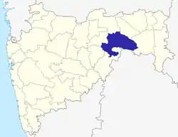 | |
| Geography | ||
| Cities and towns | ||
| Villages | ||
| Transport | ||
| Culture | ||
| Lok Sabha constituencies | ||
| Vidhan Sabha constituencies | ||
