Lumbini Province
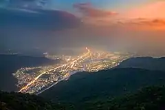
Lumbini Province (Nepali: लुम्बिनी प्रदेश, Lumbini Pradesh) is one of the seven provinces established by the new constitution of Nepal which was adopted on 20 September 2015.[1] The province is Nepal's fourth most populous province and third largest province by area. Lumbini is bordered Gandaki Province and Karnali Province to the north, Sudurpashchim Province to the west, Uttar Pradesh and Bihar of India to the south. Lumbini is one of the two Nepalese provinces to have an international border only with India. Lumbini's capital, Deukhuri, is near the geographic centre of the province; it's a small town which is currently being developed to meet the prerequisite of provincial capital. The major cities in this province are Butwal and Siddharthanagar in Rupandehi District, Nepalgunj in Banke District, Tansen in Palpa District, and Ghorahi and Tulsipur in Dang District.
Lumbini Province
लुम्बिनी प्रदेश Lumbini Pradesh | |
|---|---|
.jpg.webp) 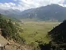 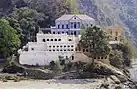   From Top left to right Maya Devi Temple at Lumbini, Dhorpatan Hunting Reserve, Ranighat Palace, Bageshwori Temple and a Bengal tiger at Bardiya National Park | |
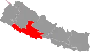 Location of Lumbini Province | |
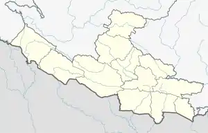
Divisions of Lumbini | |
| Coordinates: 27°39′33.13″N 83°26′18.3″E | |
| Country | |
| Formation | 20 September 2015 |
| Capital | Deukhuri |
| Largest City | Ghorahi |
| Districts | 12 |
| Government | |
| • Body | Government of Lumbini Pradesh |
| • Governor | Dharmanath Yadav |
| • Chief Minister | Shankar Pokharel (NCP) |
| • High Court | Tulsipur High Court |
| • Provincial Assembly | Unicameral (87 seats) |
| • Parliamentary constituency | 26 |
| Area | |
| • Total | 22,288 km2 (8,605 sq mi) |
| Area rank | 3rd |
| Population (2011) | |
| • Total | 4,499,272 |
| • Rank | 4th |
| • Density | 200/km2 (520/sq mi) |
| • Density rank | 3rd |
| Demonym(s) | Tarai Pashchimeli Nepali |
| Time zone | UTC+5:45 (NST) |
| Geocode | NP-FI |
| Official language | Nepali (51.6%) |
| Other language(s) | 1. Tharu 2. Awadhi 3. Magar 4. Gurung 5. Newari |
| HDI(2011) | 0.519 (low) |
| Literacy | 66.43% |
| Sex ratio | 90.43 ♂ /100 ♀ (2011) |
| Website | http://ocmcm.p5.gov.np/ |
Etymology
Lumbini Province is named after the holy pilgrimage site of Lumbini in the Rupandehi District, birthplace of Gautama Buddha - the founder of Buddhism. The Provincial Assembly adopted Lumbini Province as the permanent name by replacing its initial name Province No. 5 on 6 October 2020 and Deukhuri was declared the state capital of the province.[2][3][4]
Geography
Lumbini, with an area of 22,288 square kilometers (8605.44 sq. mi) covers about 15.1% of the country's total area. Lumbini Province is almost the size of US state of New Jersey. The province extends 150 km (31 mi) north to south and about 300 km (186 mi) east to west at its maximum width. It shares 385.2 km (239.3 mi) of border with India.[5]
The Province is surrounded by hills in the north and Indo-Gangatic Plains in south. The eastern boundary is formed by the Kali Gandaki River. Lumbini Province mainly consists of Terai plains, Hills and Valleys. River basins such as Karnali, East Rapti, Babai, Gandaki and Tinau are reliable source of water and also provide potential opportunities for hydro-power generation and irrigation in the downstream. Half of the province is forested, 29% land is arable and 14% of the land is utilized for housing purpose.[6]
Land Utilization in Lumbini
Topographically, the province can be divided into five main regions starting from the North, viz.
1) High Himalayas (3.1%)
2) High Mountains (9.1%)
3) Middle Mountains/Hills (32.2%)
4) Siwalik region (27.9%)
5) Terai region (27.6%).
43.3 percent provincial land is at an altitude of less than 500 meters. This area is mostly covered by fertile land and dense forest. 20.4 percent of area is at an altitude of 500-1000 meters. 24.2 percent land is at an altitude of 1000 to 2000meters. Similarly 7.4 percent land is at an altitude of 2000 to 3000 meters and land above 3000 meters altitude is 4.9 percent.[7]
Climate
Lumbini has a humid subtropical climate and experiences four seasons. The winter in January and February is followed by summer between March and May and the monsoon season between June and September.[8] In winter, it's sunny and mild, pleasantly warm during the day but cool at night, sometimes even cold. The average temperatures in January is around 15 °C (59 °F). But the northern parts of province gets colder and can experience snowfall. By March, the temperature rises considerably and it begins to be hot, while from April to June it's scorching hot, and highs can reach or exceed 40 °C (104 °F) in southern plains.
In June, the summer monsoon arrives, characterized by heavy rains, in the form of downpours and thunderstorms. The monsoon arrives first in the east, in early June, while in the west it comes in the middle of the month or so. The temperature decreases, with the maximum dropping to around 32 °C (90 °F) in July and August, but the humidity increases, making the heat muggy. The rains are intense especially in July and August, when they exceed 300 millimeters (12 inches) per month, but in certain areas at the foot of the mountains, they can exceed 600 mm (23.5 in) per month.[9]The monsoon starts to withdraw by early October in the west, and about a week later in the east. The weather returns to be sunny, and even though October is still a hot month, the humidity decreases and the night temperature becomes a bit cooler.
| Location | August
(°F) |
August
(°C) |
January
(°F) |
January
(°C) |
Annual
Precipitation (mm/in) |
|---|---|---|---|---|---|
| Butwal | 79 | 26.1 | 55.6 | 13.1 | 1827.2/71.9 |
| Gulariya | 84.4 | 29.1 | 59.4 | 15.2 | 1503.7/59.2 |
| Nepalgunj | 84.4 | 29.1 | 59.5 | 15.3 | 1302.1/51.3 |
| Siddharthanagar | 79.7 | 29 | 55.4 | 15.9 | 1762.7/69.4 |
| Sitganga | 75.6 | 24.2 | 51.8 | 11 | 1633.2/64.3 |
| Tansen | 76.8 | 24.9 | 53.4 | 11.9 | 1949.3/76.7 |
| Tulsipur | 79.7 | 26.5 | 55.4 | 13 | 1495.4/58.9 |
Dang-Deukhuri
These valleys are located in the Dang Deukhuri District. The Dang Valley lies between the Mahabharat Range in the north and the Churia Range in the south. It forms a nearly 1,000 km2 (390 sq mi) plain within a local drainage basin of less than 3,000 km2 (1,200 sq mi). It is drained by the Babai River, and is one of the largest Inner Terai valleys. Deukhuri Valley is southeast of the Dang Valley and extends about 60 km (37 mi) in WNW-ESE direction with a maximum width of 20 km (12 mi). It forms a nearly 600 km2 (230 sq mi) plain within a drainage basin of 6,100 km2 (2,400 sq mi). The valley is drained by the West Rapti River.
Other small valleys are in districts like Arghakhanchi (Rapti), Palpa(Rampur), Gulmi (Simaltari), Pyuthan (Darban and Bajipur).[11]
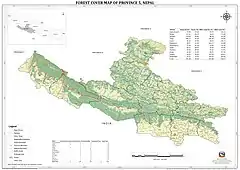
Forests
About 15% of the total land is covered in protected forest in the province.
| Districts | Forest (%) | Area (ha.th.) |
|---|---|---|
| Arghakhanchi | 59.69 | 73.96 |
| Banke | 62.70 | 117.91 |
| Bardiya | 56.82 | 113.69 |
| Dang | 65.60 | 200.72 |
| Gulmi | 41.83 | 46.34 |
| Kapilvastu | 36.92 | 60.97 |
| Parasi | 81.30 | 22 |
| Palpa | 56.62 | 82.77 |
| Pyuthan | 48.95 | 64.67 |
| Rolpa | 52.82 | 99.60 |
| Rukum | 39.39 | 66.25 |
| Rupandehi | 19.54 | 25.51 |
| Total | 50.43 | 974.38 |
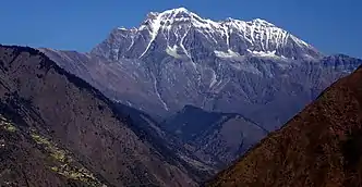
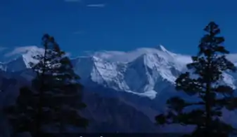
Mountains
Being the only mountain district of Lumbini province, most of the prominent peaks of the province lie in Eastern Rukum District along the Dhaulagiri range.
- Mount Putha I (Eastern Rukum District, Range : Dhaulagiri Range)
- Mount Putha II (Eastern Rukum District, Range : Dhaulagiri Range)
- Mount Sisne I (Eastern Rukum District, Range : Dhaulagiri Range)
- Mount Sisne II (Eastern Rukum District, Range : Dhaulagiri Range)
- Mount Dogari (Eastern Rukum District, Range : Dhaulagiri Range)
- Mount Samjang (Eastern Rukum District, Range : Dhaulagiri Range)
- Mount Nimku (Eastern Rukum District, Range : Dhaulagiri Range)
Demographics
In 2011 Lumbini had a census population of 4,499,272 with 885,203 households.[15]Out of total population 51.68% of the provincial population is residing in the urban area. [16]
Ethnicity
| Ethnicity | Percentage |
|---|---|
| Khas Arya | 28.84% |
| Magar | 15.27% |
| Tharu | 15.18% |
| Dalit | 15.11% |
| Others | 14.35% |

Religion in Lumbini
Language
Nepali is the most spoken language of the province, but is also a home to Tharu community and 'Tharu language' with 600,000 speakers. The province also has many speakers of Bhojpuri, Awadhi, Urdu and Magar languages.[18]
| Languages | Percentage Speakers | Number of Speakers |
|---|---|---|
| Nepali | 50.09% | 2,273,980 |
| Tharu | 13.3% | 595,304 |
| Bhojpuri | 11.4% | 508,630 |
| Awadhi | 11.2% | 497,701 |
| Urdu | 5.1% | 228,371 |
| Magar | 4.6% | 204,034 |
| Maithali | 1.2% | 54,135 |
| Newari | 0.6% | 27,413 |
| Gurung | 0.4% | 19,520 |
| Other | 1.3% | 56,097 |
Administrative subdivisions
There are total 109 local administrative units in the province which include 4 sub-metropolitan cities, 32 urban municipalities and 73 rural municipalities.[20]
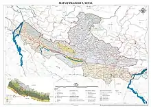
Districts
Districts in Nepal are second level of administrative divisions after provinces. Lumbini Province is divided into 12 districts, which are listed below. A district is administrated by the head of the District Coordination Committee and the District Administration Officer. The districts are further divided to municipalities or rural municipalities.
After the state's reconstruction of administrative divisions, Nawalparasi District and Rukum District were divided into Parasi District and Nawalpur District, and Eastern Rukum District and Western Rukum District respectively.[21]
| Districts | Nepali | Headquarters | Area (km2.) | Population (2011)[22] | Official Website |
|---|---|---|---|---|---|
| Kapilvastu District | कपिलवस्तु जिल्ला | Taulihawa | 1,738 | 571,936 | |
| Parasi District | परासी जिल्ला | Ramgram | 634.88 | 321,058 | |
| Rupandehi District | रुपन्देही जिल्ला | Siddharthanagar | 1,360 | 880,196 | |
| Arghakhanchi District | अर्घाखाँची जिल्ला | Sandhikharka | 1,193 | 197,632 | |
| Gulmi District | गुल्मी जिल्ला | Tamghas | 1,149 | 280,160 | |
| Palpa District | पाल्पा जिल्ला | Tansen | 1,373 | 261,180 | |
| Dang Deukhuri District | दाङ देउखुरी जिल्ला | Ghorahi | 2,955 | 552,583 | |
| Pyuthan District | प्युठान जिल्ला | Pyuthan | 1,309 | 228,102 | |
| Rolpa District | रोल्पा जिल्ला | Liwang | 1,879 | 224,506 | |
| Eastern Rukum District | पूर्वी रूकुम जिल्ला | Rukumkot | 1,161.13 | 53,018 | |
| Banke District | बाँके जिल्ला | Nepalganj | 2,337 | 491,313 | |
| Bardiya District | बर्दिया जिल्ला | Gulariya | 2,025 | 426,576 | |
| Lumbini Province | लुम्बिनी प्रदेश | Deukhuri | 22,288 km² | 4,499,272 |
Municipality
Cities and villages are governed by municipalities in Nepal. A district may have one or more municipalities. Lumbini has two types of municipalities.
- Urban Municipality (Urban Municipality has three levels):
- Metropolitan city (Mahanagarpalika)
- Sub-metropolitan city (Upa-mahanagarpalika) and
- Municipality (Nagarpalika)
- Rural Municipality (Gaunpalika)
The government of Nepal has set out a minimum criteria to meet city and towns. These criteria include a certain population, infrastructure and revenues.
Government
The Governor acts as the head of the province while the Chief Minister is the head of the provincial government. The Chief Judge of the Tulsipur High Court is the head of the judiciary.[23]Following the win of the left alliance in the 2017 election, the current Chief Minister of Lumbini Province and Leader of the ruling party is Shankar Pokharel.[24][25] The Speaker of the Assembly is Purna Bahadur Gharti.[26] Umakanta Jha is the first Governor of Lumbini Province.[27] Current Governor Dharma Nath Yadav was appointed on 4 November 2019 by the President of Nepal.[28]
Provincial Assembly
Lumbini provincial assembly is the unicameral legislative assembly consisting of 87 members. Candidates for each constituency are chosen by the political parties or stand as independents. Each constituency elects one member under the first past the post(FPTP) system of election. The current constitution specifies that sixty percent of the members should be elected from the first past the post system and forty percent through the party-list proportional representation(PR) system. Women should account for one third of total members elected from each party and if one-third percentage are not elected, the party that fails to ensure so shall have to elect one-third of total number as women through the party-list proportional representation.
| Party | FPTP | PR | Total | |||||
|---|---|---|---|---|---|---|---|---|
| Votes | % | Seats | Votes | % | Seats | |||
| CPN (Unified Marxist-Leninist) | 572,942 | 31.35 | 28 | 533,613 | 33.10 | 13 | 41 | |
| Nepali Congress | 646,200 | 35.36 | 7 | 530,844 | 32.93 | 12 | 19 | |
| CPN (Maoist Centre) | 285,878 | 14.64 | 14 | 239,281 | 14.84 | 6 | 20 | |
| Federal Socialist Forum, Nepal | 97,892 | 5.36 | 3 | 78,567 | 4.87 | 2 | 5 | |
| Rastriya Janata Party Nepal | 54,529 | 2.98 | 0 | 54,110 | 3.36 | 1 | 1 | |
| Rastriya Janamorcha | 15,803 | 0.86 | 0 | 32,546 | 2.02 | 1 | 1 | |
| Others | 105,363 | 6.77 | 0 | 143,219 | 8.88 | 0 | 0 | |
| Independent | 49,024 | 2.68 | 0 | – | – | – | 0 | |
| Invalid/Blank votes | 90,857 | – | – | 306,734 | – | – | – | |
| Total | 1,918,488 | 100 | 52 | 1,918,914 | 100 | 35 | 87 | |
| Registered voters/turnout | 2,740,867 | 70.03 | – | 2,740,867 | 70.01 | – | – | |
| Source: Election Commission of Nepal | ||||||||

Economy
Lumbini province is the fastest growing province of Nepal with an annual economic growth rate of 7.1%[29] and is third out of the seven provinces in terms of its contribution to the GDP (13%, NPR 452.79 Billion as of 2019).[30][31][32]Agriculture, forest and tourism are the mainstay of province economy.
There are 614 commercial banks, 307 development banks, 34 finance companies, 900 Microfinance companies. Similarly, there are 272 life and 190 non life insurance companies and their branches in the province. Construction of the Gautam Buddha International Airport, establishment of industrial units in Special Economic Zone, and the opening of new hotels are expected to spur further economic growth in the province.[33]
Agriculture
The province has both temperate and tropical climates and is diverse in terms of agriculture crop production potentialities. With five core terai districts, one inner terai and 6 other hill districts the province is best suited for agriculture production as the land is very fertile and good source of irrigation prevails. Sikta Irrigation project and Babai Diversion and Irrigation project have benefited the agricultural production. The major crops are paddy, mustard, wheat, maize, sugarcane, vegetables, potato, lentils and cotton.[34] Lumbini is self-sufficient in cereal crops and pulses.
| Land use | Percentage | Area (Hectares) |
|---|---|---|
| Arable Land | 45.5% | 404,541 |
| Temporary Crops | 44.9% | 398,849 |
| Permanent Crops | 5% | 44,388 |
| Woodland/Forest | 0.9% | 8,343 |
| Meadows/Pasture | 0.6% | 5,561 |
| Temporary Fallow | 0.5% | 4,389 |
| Temporary Meadows | 0.2% | 1,303 |
| Pondes | 0.1% | 828 |
| Other | 2.4% | 21,017 |
Productivity of paddy in the province is 3.91 MT per ha, which is above the national average productivity of 3.8MT per ha. Out of the total paddy production in the country Lumbini Province comprises 21.4%. Similarly 24.7% of Wheat and 13.9% Maize is produced in the province.
Irrigation
316000 ha of agriculture land are irrigated through 541 irrigation systems in the province. Similarly, there are various irrigation projects under construction, namely, Bheri Babai diversion, Babai, Sikta. After completion all these big irrigation projects will irrigate approximately 140000 ha of land. Some irrigation projects are listed below:
Energy
91% of the population has access to electricity in the province. Of the 12 districts in Lumbini Province, Parasi, Kapilvastu and Bardiya have been electrified by more than 99 percent. Gulmi, Arghakhanchi and Rupandehi have more than 95 percent electrification and Rukum East has the lowest electrification of 11.25 percent.[36] Lumbini generates 21.2 MW of electricity from hydropower.[37] Total number of electricity consumers in the province is 457992, consuming 370.8 Million MWh of energy annually. According to NEA, Distribution and Consumer Service Directorate 93% of consumers are domestic users; loss of electricity in the province is 12.17% for the year 2076/77 (2020 AD). Out of the total loss in distribution provincial office, Gularia contributes the highest loss percentage of 25.02%.
Butwal Solar PV Project, Nepal's first private grid-connected solar power plant was connected to national transmission line on October 2020. Ridi Hydropower Company has constructed the power plant in Tilottama of Rupendehi District. With over 32,000 solar panels of 330 watts each, the plant can generate 8.5 MW of electricity.[38]
Industry
There are 522 industries registered under department of industry. Out of total number of industries Production based industry shares the highest number i.e. 418. While there are only 24 Agriculture and forestry based industry. There are 14715 companies registered under company act in the province. Similarly, 68334 small, cottage and micro level industries are registered in the province. These industries create an estimated 477654 employment.[39]
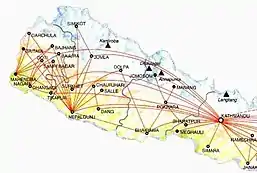
Transportation
Transportation routes in Lumbini evolved since Mahendra highway (![]() H01). Lumbini has two major routes,
H01). Lumbini has two major routes, ![]() H01 and
H01 and ![]() H10 both intersecting in Butwal. 8931 km of road is constructed in the Province. Out of which 5293 km is blacktopped.
H10 both intersecting in Butwal. 8931 km of road is constructed in the Province. Out of which 5293 km is blacktopped.
Bhairahawa and Nepalgunj have always been major trade routes with India. Lumbini has no railways but East West railway, Kathmandu-Lumbini railway and several other routes connecting Indian cities are planned.[40][41][42]
Air Travel
Gautam Buddha International Airport and Nepalgunj Airport are major airstrips in the province. Being mostly flat land air travel isn't preferable but Nepalgunj Airport serves as hub for most of the airports in Karnali Province and Sudurpaschim Province. New airports are under construction in Resunga (Gulmi District) and Sandhikharka (Arghakhanchi District).[43][44]
Popular lakes
- Satyawati
- Bahrakune
- Jagadishpur
- Rukmini
- Jakhera
Religious and tourist centers
Universities
- Nepal Sanskrit University
- Rapti Academy of Health Sciences
- Lumbini Bauddha University
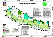
Protected areas
See also
- List of Provinces of Nepal
- List of Districts of Nepal
- List of Mayor of Nepal
- List of Districts of Lumbini
References
- "Nepal Provinces". statoids.com. Retrieved 21 March 2016.
- "It's official now: Dang is capital of Province 5, renamed as Lumbini". OnlineKhabar. Retrieved 6 October 2020.
- "Province 5 to be named Lumbini, Dang's Deukhuri permanent capital". MyRepública. Retrieved 6 October 2020.
- "Province 5 named Lumbini Province after 79/83 votes". AjakoNepal. Retrieved 6 October 2020.
- Shrestha, SI Arjun. "Introduction". lumbini.nepalpolice.gov.np. Retrieved 12 January 2021.
- "Lumbini Province". Nepal Outlook | Believe in Data. Retrieved 17 January 2021.
- "Lumbini Province". Nepal Outlook | Believe in Data. Retrieved 17 January 2021.
- "Department of Hydrology and Meteorology". www.dhm.gov.np. Retrieved 2 January 2021.
- "Nepal climate: average weather, temperature, precipitation, best time". www.climatestotravel.com. Retrieved 2 January 2021.
- "Nepal Travel Weather Averages (Weatherbase)". Weatherbase. Retrieved 28 April 2018.
- Shrestha, Surendra; Shah, Surendra. "Inventory of Valleys in Nepal". Cite journal requires
|journal=(help) - "DNPWC". Department of National Parks and Wildlife Conservation. Retrieved 4 January 2021.
- "Ministry of Forests and Environment". mofe.gov.np. Retrieved 26 October 2020.
- "Ministry of Forests and Environment". mofe.gov.np. Retrieved 26 October 2020.
- "Nepal: Administrative Division (Provinces and Districts) - Population Statistics, Charts and Map". www.citypopulation.de. Retrieved 29 October 2020.
- "Lumbini Province". Nepal Outlook | Believe in Data. Retrieved 17 January 2021.
- "NID | Overview". nepalindata.com. Retrieved 24 October 2020.
- "NepalMap profile: Province No. 5". NepalMap. Retrieved 14 October 2020.
- "NepalMap profile: Province No. 5". NepalMap. Retrieved 14 October 2020.
- "स्थानिय तह". 103.69.124.141. Archived from the original on 31 August 2018. Retrieved 27 April 2018.
- "Govt decides to divide parts of Rukum and Nawalparasi". kathmandupost.com. Retrieved 1 January 2021.
- 2011 Census District Level Detail Report Archived 2018-09-02 at the Wayback Machine, Central Bureau of Statistics.
- "High Courts get their chief judges". Retrieved 27 April 2018.
- "Pokharel elected PP leader of Province 5, other provinces awaiting party decision". Setopati. Retrieved 1 January 2021.
- Republica. "Pokharel appointed Province-5 Chief Minister". My Republica. Retrieved 1 January 2021.
- "Yadav, Gharti sworn in as speakers". kathmandupost.com. Retrieved 1 January 2021.
- "Government finalises provinces' governors and temporary headquarters | NepaleKhabar.com". nepaleKhabar. 17 January 2018. Retrieved 1 January 2021.
- "Who is who: These are new governors of Nepal's seven provinces". OnlineKhabar English News. Retrieved 1 January 2021.
- Khatiwada, Dr. Yuba Raj. "Economic survey 2018/19, Government of Nepal, Ministry of Finance". Government of Nepal, Ministry of Finance: 14.
- "Province wise GDP, Nepal". kathmandupost.com. Retrieved 24 October 2020.
- "PROVINCE WISE GDP OF NEPAL 2019". nepalindata.com. Retrieved 24 October 2020.
- "Lumbini Province". Nepal Outlook | Believe in Data. Retrieved 17 January 2021.
- "Airport construction triggers hotel boom in Rupandehi". kathmandupost.com. Retrieved 29 October 2020.
- "कृषि विभाग". doanepal.gov.np. Retrieved 4 January 2021.
- "NepalMap profile: Province No. 5". NepalMap. Retrieved 24 October 2020.
- Republica. "Over 86 percent households have now access to electricity through national grid". My Republica. Retrieved 29 October 2020.
- "Ministry of Finance - Government of Nepal". www.mof.gov.np. Retrieved 24 October 2020.
- "Butwal Solar Power Project (8.5 MW) Connected To National Transmission Line". Investopaper. Retrieved 31 October 2020.
- "Lumbini Province". Nepal Outlook | Believe in Data. Retrieved 17 January 2021.
- Pariyar, Binod. "Survey begins for Mechi-Mahakali Electric Railway". My Republica. Retrieved 29 October 2020.
- "At upcoming talks, Nepal and China to discuss Kathmandu-Pokhara-Lumbini railways". kathmandupost.com. Retrieved 29 October 2020.
- "India willing to expedite Kathmandu-Raxaul railway project". Khabarhub. Retrieved 29 October 2020.
- "Arghakhanchi airport construction project initiates". Aviation Nepal. 14 December 2017. Retrieved 26 October 2020.
- "Reshunga Airport to see its runway blacktopped". Aviation Nepal. 28 April 2019. Retrieved 26 October 2020.
Places adjacent to Lumbini Province | ||||||||||
|---|---|---|---|---|---|---|---|---|---|---|
| ||||||||||
Nepal articles | ||||||||||||||||||
|---|---|---|---|---|---|---|---|---|---|---|---|---|---|---|---|---|---|---|
| History |
|  | ||||||||||||||||
| Geography |
| |||||||||||||||||
| Politics |
| |||||||||||||||||
| Economy | ||||||||||||||||||
| Culture |
| |||||||||||||||||
| ||||||||||||||||||