Chitwan District
Chitwan District (/ˈtʃɪtəˌwʌn/, Nepali: चितवन, [ˈtsit̪ʌwʌn] (![]() listen)) is one of 77 districts of Nepal, and takes up the southwestern corner of Bagmati Province. Bharatpur, largest city of Nepal after Kathmandu, is its administrative centre. It covers 2,238.39 km2 (864.25 sq mi), and in 2011 had a population of 579,984 (279,087 male and 300,897 female) people.[3] Bharatpur is the commercial and service centre of South Central Nepal and a major destination for higher education, health care and transportation in the region. Chitwan lies in the Terai region of Nepal. It is in the drainage basin of the Gandaki River and is roughly triangular, taking that river as its meandering northwestern border, and a modest watershed border, with India, as the basis of its southern limit.
listen)) is one of 77 districts of Nepal, and takes up the southwestern corner of Bagmati Province. Bharatpur, largest city of Nepal after Kathmandu, is its administrative centre. It covers 2,238.39 km2 (864.25 sq mi), and in 2011 had a population of 579,984 (279,087 male and 300,897 female) people.[3] Bharatpur is the commercial and service centre of South Central Nepal and a major destination for higher education, health care and transportation in the region. Chitwan lies in the Terai region of Nepal. It is in the drainage basin of the Gandaki River and is roughly triangular, taking that river as its meandering northwestern border, and a modest watershed border, with India, as the basis of its southern limit.
Chitwan
चितवन | |
|---|---|
District | |
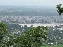 Narayangarh city view from Maula Kalika temple Gaindakot | |
| Motto(s): हाम्रो चितवन, राम्रो चितवन | |
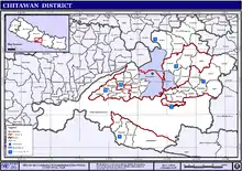
 Location in Bagmati Province | |
| Coordinates: 27°35′N 84°30′E | |
| Country | Nepal |
| Province | Bagmati Province |
| Headquarters | Bharatpur |
| HDI | |
| HPI | |
| Literacy Rate | |
| Established | 14th century[2] |
| Area | |
| • Total | 2,238.39 km2 (864.25 sq mi) |
| Elevation | 415 m (1,362 ft) |
| Population (2014) | |
| • Total | 579,984[3] |
| • Ethnicities | Brahmin Chhetri Tharu Newar Darai Gurung Magars Tamang Chepang Pariyar |
| • Religions | Hindu Buddhist Christian |
| Languages | |
| • Local | Nepali, Tharu, Newari, Tamang, Gurung, Darai, Magar, Chepang |
| • Official | Nepali |
| Time zone | UTC+5:45 (Nepal Time) |
| Area code(s) | 056 |
| Website | www.ddcchitwan.gov.np |
History
The district takes its name from the Chitwan Valley, one of Nepal's Inner Terai valleys between the Mahabharat and Siwalik ranges, both considered foothills of the Himalayas.
Chitwan is one of the few remaining undisturbed vestiges of the Terai region, which formerly extended over the foothills of Nepal. It was originally a dense forest with wild animals like leopards and Bengal tigers. It was ruled by Chitrsen Baba and rishis meditated in the forest. .
Ayodhyapuri, situated in Southern Chitwan, is thought by Hindus in Nepal to be the birthplace of the Hindu deity Ram.[4]
Etymology
There are several theories on the origin of the name Chitwan:
- The name Chitwan is a composite of the Sanskrit words चित्त, transliterated "citta" meaning heart, and वन, transliterated "vana" meaning jungle or forest.[5][6] Thus, the meaning of Chitwan is Heart of the Jungle.
- Chitwan was a dense forest ruled by the Tharu God-King Chitrasen Baba, thought to an incarnation of Vishnu. Today, the Tharu worship his idol during HariBodhini Ekadashi in Chitrasari en route to the village of Sauraha. Ban (वन) is the local word for a forest, according to this theory, the area was called Chitra Ban (Chitrasen's forest) which then became Chitwan.
- The Chitwan forests were populated by leopards and Bengal tigers and, since the Tharu term for a leopard is Chitra, the area became Chitwan.
- Chitra is also the Tharu word for religious drawings and, hence, "Chitra ban" became Chitwan.
Agriculture and industry
The people inhabiting the Chitwan District are predominantly peasant farmers cultivating mainly food and cash crops such as rice, maize, wheat, beans, lentils, mustard and Vegetables. The district is the major maize-producing area in Nepal, with an area under maize cultivation of 27,170 ha (104.9 sq mi) in the year 2003–04. Maize is cultivated on irrigated /seasonal irrigated land in winter and spring, and on rain fed land in summer. Because it is easily accessible by good roads, maize produced in the district can be easily distributed to other parts of the country. Poultry is also a significant industry in Chitwan.[7]
Chitwan is famous in Nepal for mustard growing and production of mustard oil. This popularity of the mustard in Chitwan is attributed to the predominant soil type silt, resulting from the flooding of the Narayani River and its tributaries. The land in Chitwan is also spotted with clay, which is very good for growing rice, wheat and vegetables such as cabbage, cauliflower, radish, potatoes, broccoli, cucumbers, pumpkins, sweet potatoes and carrot. Chitwan is also famous for floriculture, mushroom cultivation and bee keeping.
Chitwan has adopting the South Korean New Community Movement model of development. One of the biggest rice mills in Nepal, Agam Food Industry, is situated in Bharatpur and is a big source of local employment.
Cuisine
Chitwan is known for Taas (Nepali: तास), a spicy fried goat meat dish served with bhuja or cheura. Momos, Bhuteko Bhat (fried rice), and sukuti are other popular dishes. Dal bhat (steamed rice and lentils), is the staple food of the area, though meat and dairy products are also consumed. Other popular cuisines include Newari and Tharu and Thakali. For centuries, traditional fermented foods and beverages have constituted about 20% of the local diet. Depending on altitudinal variation, finger millet, wheat, buckwheat, barley, vegetable, rice, potato, and soybeans etc. are grown.
Gallery
| Chitwan National Park | |
|---|---|
IUCN category II (national park) | |
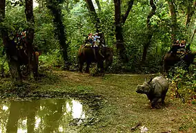 Elephant safari after an Indian rhinoceros |
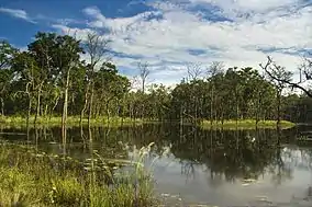 Beeshazar Lake near Chitwan National Park
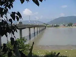 Narayani bridge in Narayangarh, Chitwan, Nepal
 Elephant polo World cup 2012 in Meghauli, Nepal
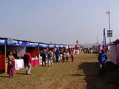 Chitwan Mahotsav 2063 (Chitwan Mahotsav 2007 A.D.) in Narayangarh, Chitwan
Geography
The Rapti River flows east to south west in the south of Bharatpur and forms the northern border of the Chitwan National Park. The Narayani River flows north to south to the west of Bharatpur. It is the deepest and one of the biggest rivers of Nepal. The Narayani Bridge over the river connects Chitwan District with Nawalparasi District of Nepal.
Chitwan is particularly rich in flora and fauna. Nepal's first national park, the Chitwan National Park together with the adjacent Parsa National Park support a diversity of species that is much higher than elsewhere on the Indian subcontinent. Rare species include Bengal tiger, gharial, rhino, leopards, mugger crocodile, Indian rock python and several species of deer. The protected areas are guarded by a battalion of the Nepal Army and patrolled by anti-poaching units.[8] Bishazari Tal ("20 Thousand") Lake is near Chitwan National Park, about 5 km (3.1 mi) south of Bharatpur. The lake is an important bird watching centre. I
Transportation and communication
_2.jpg.webp)
Bharatpur Airport is the only airport in the region and has flights to and from Kathmandu. Mahendra Highway, the main east–west highway in Nepal, runs through the region and, Prithvi Highway a north–south highway from the border with India to Kathmandu runs through the district. Narayangarh is the main transit point for vehicles travelling via the east–west Mahendra Highway and also for people travelling from Kathmandu, Gorkha, and Pokhara through Mugling.
There are numerous local FM radio stations broadcasting from Bharatpur: Synergy FM,[9] Hamro FM, Radio Triveni, Radio Madi, Radio Chitwan,[10] Radio Kotagiri, Chitwan Online FM, Kalika Music FM, Kalika FM.[11] and Narayani FM. Television channels include Beso Channel, Aviyan Channel, Unique Television and Avass Television. There are multiple private Internet service providers. Fibre connectivity and 4G internet is available in the larger cities.
Landmark buildings
- Upardanghari fort, in the old headquarters of Chitwan district, is believed to have been built by Satrubhanjan Shah, the son of Prince Bahadur Shah to defend the newly founded Kingdom in the 17th century.
- Kasara Durbar is an old palace built by the Rana Regime inside Chitwan National Park. Currently, it serves as the park office and museum.
- Diyalo Bangala Palace (Aptari Bharatpur) was the spring season palace used by the Shah Dynasty of Nepal. This palace was built by late king Mahendra Bir Bikram Shahdev to rest in during winter season. It is located on the banks of Narayani River in Bharatpur Municipality ward no. 2.
- DAO Building Bharatpur: This old building was built in the period of shifting the headquarters from Upardangghari. Now is used as an office of the chief district officer.
- Bharatpur Covered hall: Hall in guesthouse of Bharatpur for indoor games.
Geography and climate
| Climate Zone[12] | Elevation Range | % of Area |
|---|---|---|
| Lower tropical | below 300 m (980 ft) | 58.2% |
| Upper tropical | 301 to 1,000 m (988 to 3,281 ft) | 32.6% |
| Subtropical | 1,001 to 2,000 m (3,284 to 6,562 ft) | 6.7% |
Major places
- Ayodhyapuri
- Dibyanagar
- Bharatpur
- Narayangarh Bazaar
- Tandi bazaar
- Parsa Bazaar
- Parsadhap Bazaar
- Birendranagar Bazaar
- Muglin Bazaar
- Rampur Bazaar
- Gitanagar bazaar
- Bhandara Bazaar
- Chanauli Bazaar
- Mangalpur Bazaar
- Manakamana
- Shivanagar bazaar
- Basantapur Bazaar, Madi
- Patihani bazaar
- Parbatipur Bazaar
- Saradanagar bazaar
- Jagatpur Bazaar
- Meghauli-Telauli Bazaar
- Lothar Bazaar
- Sauraha
- Kasara
- Dasdhunga
Demographics
At the time of the 2011 Nepal census, Chitwan District had a population of 579,984. Of these, 70.1% spoke Nepali, 10.2% Tharu, 4.9% Tamang, 3.7% Chepang, 2.8% Gurung, 1.7% Bhojpuri, 1.6% Magar, 1.6% Newari, 1.1% Darai, 0.6% Maithili and 0.5% Hindi as their first language.
Of the population, 27.3% in the district spoke Nepali as their second language.[13]
Administration
The district consists of seven municipalities, out of which one is a metropolitan city, five are urban municipalities and one is a rural municipality.[14]
- Bharatpur Metropolitan City
- Kalika Municipality
- Khairahani Municipality
- Madi Municipality
- Ratnanagar municipality
- Rapti Municipality
- Ichchhakamana Rural Municipality
Former municipalities and gaunpalikas
Prior to the restructuring of the district, Chitwan had following gaunpalikas and municipalities.[15]
Health care
Chitwan district is known for its hospitals and has many top rated medical institutions, mostly in and around Bharatpur Municipality. The district is especially known for the B. P. Koirala cancer hospital at Krishnapur. Chitwan ranks just behind Kathmandu, Biratnagar and Pokhara, in hospital facilities in Nepal. Medical facilities in the district include Bharatpur Hospital, a part of the Bharatpur medical college; Chitwan Medical College, a new university hospital; Chitwan Eye Hospital; B.P. Koirala Memorial Cancer Hospital; College of medical sciences, affiliated to Kathmandu University; Sairam Dental Hospital and Research Center; Maula Kalika Hospital; and Narayani Community Hospital.
Educational institutions
- Polar Star Secondary English Boarding School, Bharatpur 9 Gauriganj
- Shree Sharadpur Higher School

- Little Stars Secondary English Boarding School. Bharatpur 7, Krishnapur.
- SOS Hermann Gmeiner School Bharatpur, Bharatpur-8, Chitwan
- Holy Vision Public School, Yagyapuri, Bharatpur-4
- Grandee English Boarding School, Bharatpur-19
- Shanti Vidya Mandir English School, Bharatpur-11, Chitwan
- Sirjana English Secondary School, Located behind Central Bus Terminal (Paras Buspark)
- Boston International College, Hakim chowk, Bharatpur-10 (affiliated to Pokhara University)[16]
- School of Health Science
- Chitwan Higher Secondary School, Bharatpur-10
- Sun Rise English school, Bharatpur 10.
- Pragati Shiksha Sadan, East Rampur, Chitwan.
- Jana Jagriti Higher Secondary School, Pithuwa – 3, Pithuwa
- Aroma Higher Secondary School
- Birendra Multiple Campus is the oldest campus of the city, located in Bharatpur heights.
- Lead Academy for Science and Management Technology
- Institute of Agriculture and Animal Science, also known as the Rampur Agriculture Campus, is the agriculture institution under Tribhuvan University, and is the main institution in the fields of agriculture and veterinary science in Nepal. Occupying a huge area, this campus has been declared a university, the Agriculture and Forestry University.
- Balkumari College is located near the Narayangadh Bharatpur Height and affiliated to Tribhuvan University.
- Saptagandaki Multiple Campus is the largest public campus in the city, located in Dipendranagar ward no. 10, Bharatpur.
- Jan Aadrash multiple campus Birendranagar is the public campus in Birendranagar ward no. 2.
- Saheed Smriti Multiple campus, Shantichowk is the biggest campus of eastern Chitwan.
- Birendra higher secondary school
- College of Medical Sciences, Bharatpur is a 700-bed teaching hospital situated in Dipendranagar, Bharatpur.
- International college is a college of higher education and runs the HSEB and TU affiliated BBS and MBS programs in management streams.
- Apex Educational Academy is a higher secondary school in Bharapur.
- Valmiki Shiksha Sadan Higher Secondary School provides higher secondary education.
- Shree Medical and Technical College located in Bharatpur is affiliated to the Purbanchal University and CTEVT.
- Chitwan Health Foundation and Research Center was established in Bharatpur as the nursing School of Chitwan Hospital and Health Foundation
- Maiya Devi Girls College, located in Dipendranagar, Bharatpur.
- Chitwan Medical College and Research Centre, located in Dipendranagar, Bharatpur.
- Prerana Higher Secondary School
- SOS Hermann Gmeiner Higher Secondary School
- Chitwan Science College and Orchid Science College
- Indreni ICT college, affiliated to Tribhuvan University, located at Muktinagar, Bharatpur.
- Chitwan Hotel Training Center in Bharatpur
- Shree Prembasti Higher Secondary School, Bharatpur-7, Chitwan.
- Apex academy in Kshetrapur, Presidency college in Dipendranagar, Shanti Academy college in Bharatpur, Xavier college in Bel chowk, Sahid Smriti Multiple Campus, New Capital College, Crystal College in Ratnanagar
- Sun Rise English School
- Kamal Devi English School
- Sainik Awashiya Mahavidhyalaya Chitwan operated by Nepal army welfare fund provided education in high school level.
- Buddha Shanti Higher Secondary School, Rapti Municipality 03.
- Little Flower English school, Belchowk
- Kalika English Boarding School
- Central English Boarding School
- Balikumari College
- Small heaven School
- Nepal Police School Bharatpur-14
Notable people
- Pushpa Kamal Dahal (Prachanda): Prime Minister of Nepal 2008–09 and 2016–17; chairman of UCPN[17]
- Nilkantha Upreti: Former Chief Election Commissioner of Nepal
- Surendra Pandey: Former Finance Minister of Nepal[18]
- Ram Bahadur Thapa (Badal): Current Home Minister of Nepal[19]
- Shristi Shrestha: Miss Nepal 2012[20]
- Shiva Regmi: Nepalese Film director[21]
- Bodhraj Acharya: Nepalese scientist
- Kamal Bahadur Adhikari: Nepalese weightlifter
- Dr. Santosh Kalwar: Nepalese poet, writer, and computer researcher (first English language novelist of Chitwan)[22][23][24]
- Swopnil Sharma: Lead singer of The Shadows Nepal Band[25]
- Sandeep Lamichhane: Cricketer
- Asmi Shrestha: Miss Nepal 2016
See also
References
- Merlen, S. (ed.) (2011). An Overview of the Central Development Region. United Nations Resident & Humanitarian Coordinator's Office, Nepal
- "History". Retrieved 16 May 2010.
- "National Population and Housing Census 2011(National Report)" (PDF). Central Bureau of Statistics. Government of Nepal. November 2012. Archived from the original (PDF) on 18 April 2013. Retrieved 1 November 2012.
- "Department of Archeology team reaches Ayodhyapuri in Chitwan to conduct study on birthplace of lord Ram". Rising Nepal Daily. 16 July 2020. Retrieved 30 July 2020.
- Sanskrit-English Dictionary spokensanskrit.de: Sanskrit word चित्त
- Sanskrit-English Dictionary spokensanskrit.de: Sanskrit word वन
- Paudel, P. and A. Matsuoka (2008). Factors Influencing Adoption of Improved Maize Varieties in Nepal: A Case Study of Chitwan District Archived 31 October 2012 at the Wayback Machine. Australian Journal of Basic and Applied Sciences 2(4): 823–834.
- Gurung, K. K. (1983). Heart of the Jungle: The Wildlife of Chitwan, Nepal. André Deutsch, London.
- "Synergy FM 91.6 MHz".
- "Radio Chitwan 94.6 MHz".
- "Kalika FM 95.2 & 91 MHz".
- The Map of Potential Vegetation of Nepal – a forestry/agroecological/biodiversity classification system (PDF), Forest & Landscape Development and Environment Series 2-2005 and CFC-TIS Document Series No. 110, 2005, ISBN 87-7903-210-9, retrieved 22 November 2013
- 2011 Nepal Census, Social Characteristics Tables
- "स्थानिय तह" (in Nepali). Ministry of Federal Affairs and General Administration. Archived from the original on 31 August 2018. Retrieved 1 September 2018.
- "Nepal Census 2001". Nepal's village development committees. Digital Himalaya. Archived from the original on 12 October 2008. Retrieved 19 November 2008.
- https://bostoncollege.edu.np/
- Nepali PM Prachanda Sworn In. English.cri.cn. Retrieved 3 September 2011.
- "Surendra PandeyCommunist Party of Nepal (Unified-Marxist- Leninist) Election Area: Chitwan-1 (Elected)". Archived from the original on 7 July 2014. Retrieved 8 August 2014.
- CPN-Maoist Gen Secy Thapa bereaved of father. thehimalayantimes.com. Retrieved 1 June 2014.
- About Shristi Shrestha – Miss Nepal Archived 4 June 2014 at the Wayback Machine. shristishrestha.org. Retrieved 1 June 2014.
- Regmi no more. ekantipur.com. Retrieved 10 December 2013.
- Book launch program. Archived 8 August 2014 at the Wayback Machine. Retrieved 11 June 2014.
- 'That's My Love Story' Bimochan.. Retrieved 11 June 2014.
- Santosh Kalwar – The Kathmandu Post.. Retrieved 17 April 2017.
- The Shadows, Nepal First Hard Rock Band. Retrieved 6 August 2014.
External links
| Wikimedia Commons has media related to Chitwan District. |
| Wikivoyage has a travel guide for Chitwan. |
- "Districts of Nepal". Statoids.
Headquarters: Bharatpur | ||
| Metropolitan city |  | |
| Municipalities | ||
| Rural municipality |
| |
| Former VDCs | ||