Taplejung District
Taplejung District (Nepali: ताप्लेजुङ जिल्ला ![]() Listen ) is one[2] of 77 districts of Nepal and one of the 14 districts of Province No. 1. It is remotely located in the Himalayas in Eastern Nepal with Tibet to the north across the Himalayas. Taplejung is the 3rd largest district (by area) of Nepal.
Listen ) is one[2] of 77 districts of Nepal and one of the 14 districts of Province No. 1. It is remotely located in the Himalayas in Eastern Nepal with Tibet to the north across the Himalayas. Taplejung is the 3rd largest district (by area) of Nepal.
Taplejung
ताप्लेजुङ जिल्ला | |
|---|---|
District | |
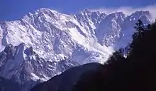
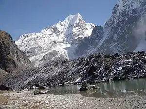    Dudhkunda at yamtari glacier on top, Gunsa in left-center, Lelep village in right-center and a view from Pathibhara temple in bottom | |
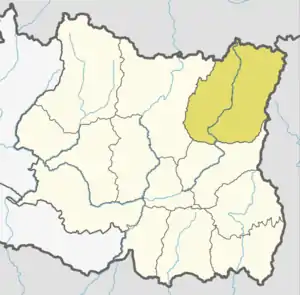 Location of Taplejing (dark yellow) in province | |
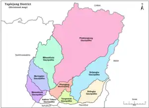 Divisional map of Taplejung | |
| Country | |
| Province | Province No. 1 |
| Established | 1962 |
| Admin HQ. | Phungling Municipality |
| Government | |
| • Type | Coordination committee |
| • Body | DCC, Taplejung |
| • Head | Mr. Ghanendra Maden |
| • Deputy-Head | Mrs. Debimaya Nepali |
| Area | |
| • Total | 3,646 km2 (1,408 sq mi) |
| Area rank | 3rd |
| Highest elevation | 8,586 m (28,169 ft) |
| Lowest elevation | 670 m (2,200 ft) |
| Population (2011)[1] | |
| • Total | 127,461 |
| • Density | 35/km2 (91/sq mi) |
| Time zone | UTC+05:45 (NPT) |
| Website | ddctaplejung |
The district covers an area of 3,646 square kilometres (1,408 sq mi) and has a total population (2011 Nepal census) of 127,461. The district is surrounded by Tibet (China) in the north, Sankhuwasabha District in the west, Tehrathum District and Panchthar District in the south and Sikkim (India) in the east. Geographically, the district is located at a latitude of 27º 06’ to 27º 55’N and a longitude of 87º57’ to 87º40’ E.[3]
Etymology
Literally meaning of Taplejung is "a fort of King Taple" in Limbu language. There was a fort situated at that area in medieval times which was built by King Taple.[4]
History
Before unification of Nepal, the area of Taplejung and surround were used to call (Pallo Kirat) Limbuwan which means "Far region" used to be ruled by Limbu kings of Limbuwan before unification.[5]
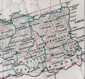
After unification of Nepal, the area of Taplejung became a part of large Dhankuta District.
In 1962 when the traditional old 32 districts divided into 75, then three thums (counties) of large Dhankuta district separately established a new district named "Taplejung".
Geography and climate
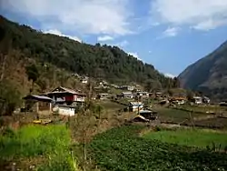
Geographically Taplejung is a mountainous district located near to the world's third highest peak Kanchenjunga (8586 m).[6] It is situated at elevation ranging from 670 metres (2,200 ft) to 8,586 metres (28,169 ft) from sea level.[7] Tamur River is a main river in the district, which flows through the middle in the district dividing district in east and west Taplejung. Gunsa river, Simbuwa river and there are many tributaries of tamor are important source of freshwater. There are over than 60 rivers and streams in the district. Some glacial lakes are: Sinjenma Pokhari, Samdo Pokhari, Tin Pokhari, Kali Pokhari etc.[8][9] The district includes many highest peaks eg. Gimmigela (7350 m), talung (7349 m), Kabru (7276 m), Nepal peak (7177 m), Kumbhkarna (7025 m) etc.[10] Kanchenjunga Conservation Area is a protected area in the district which covers an area of 2,035 square kilometres (786 sq mi).
| Climate Zone[11] | Elevation Range | % of Area |
|---|---|---|
| Upper Tropical | 300 to 1,000 meters 1,000 to 3,300 ft. |
2.4% |
| Subtropical | 1,000 to 2,000 meters 3,300 to 6,600 ft. |
14.8% |
| Temperate | 2,000 to 3,000 meters 6,400 to 9,800 ft. |
19.5% |
| Subalpine | 3,000 to 4,000 meters 9,800 to 13,100 ft. |
16.8% |
| Alpine | 4,000 to 5,000 meters 13,100 to 16,400 ft. |
38.8% |
| Nival | above 5,000 meters | 7.7% |
Demographics
At the time of the 2011 Nepal census, Taplejung District had a population of 127,461. Of these, 37.8% spoke Limbu, 37.4% Nepali, 10.7% Sherpa, 4.0% Tamang, 3.1% Gurung,0.8% Waling/Walung, 0.7% Sunuwar, 0.7% Magar and 0.7% Newari as their first language.
Administration
Taplejung District is administered by Taplejung District Coordination Committee (Taplejung DCC). The Taplejung DCC is elected by Taplejung District Assembly. The head of Taplejung DCC is Mr. Ghanendra Maden and Mrs. Devimaya Nepali is deputy head of Taplejung DCC.
Taplejung District Administration Office under Ministry of Home Affairs co-operate with Taplejung DCC to maintain peace, order and security in the district. The officer of District Administration office called CDO and current CDO of Taplejung DAO is Dorendra Niraula.
Taplejung District Court is a Judicial court to see the cases of people on district level.
| Administration | Name | Head | Website |
|---|---|---|---|
| Legislative | District Coordination Committee | Mr. Ghanendra Maden | dcctaplejung |
| Executive | District Administration Office | Mr. Dorendra Niraula | daotaplejung |
| Judicial | District Court | Mr. Prakash Raut | supremecourt |
Division
Taplejung is divided in total 9 local level bodies, in which only Phungling is an urban municipality otherwise all other local level bodies are rural municipality.
| SN | Local level unit | Type | Population | Area | No. of wards | Website |
|---|---|---|---|---|---|---|
| 1 | Phungling | urban | 26406 | 125.57 | 11 | phunglingmun |
| 2 | Aathrai Tribeni | rural | 13784 | 88.83 | 5 | aathraitribenimun |
| 3 | Sidingwa | rural | 12099 | 206 | 7 | sidingbamun |
| 4 | Phaktanglung | rural | 12017 | 1858.51 | 7 | phaktanglungmun |
| 5 | Mikkwakhola | rural | 9160 | 442.96 | 5 | mikwakholamun |
| 6 | Meringden | rural | 12548 | 210.33 | 6 | meringdenmun |
| 7 | Maiwakhola | rural | 11037 | 138 | 6 | maiwakholamun |
| 8 | Pathibhara Yangwarak | rural | 13591 | 93.76 | 6 | yangwarakmuntaplejung |
| 9 | Sirijangha | rural | 15806 | 481.09 | 8 | sirijanghamun |
Former administrative divisions
Formerly, Taplejung had one municipality and many VDCs. VDCs were the local level administrative units for villages.
Fulfilling the requirement of the new constitution of Nepal 2015, on 10 March 2017 all VDCs were nullified and formed new units after grouping VDCs.
Constituencies
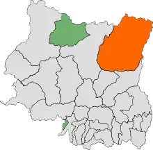
Taplejung District consists 1 Parliamentary constituency and 2 Provincial constituencies[13]
| Constituencies | Type | Area | MP/MLA | Party |
|---|---|---|---|---|
| Taplejung 1 | Parliamentary | whole Taplejung district | Yogesh Bhattarai | NCP |
| Taplejung 1(A) | Provincial | Phungling, Yangwarak, Sidingba, Sirijangha and the ward no. 3 of Phaktanglung | Bal Bahadur Samsohang | NCP |
| Taplejung 1(B) | Provincial | Aathrai Tribeni, Maiwakhola, Meringden, Mikwakhola and Phaktanglung (excluding ward no. 3) | Tanka Angbuhang Limbu | NCP |
Transportation
Taplejung (headquarters) is connected to the rest of Nepal by the Mechi Highway which meets the East-West or Mahendra Highway at Charali (Mechinagar). The distance from Mechinagar to Taplejung is 227 kilometres (141 mi).[14] A person can travel from Kathmandu to Taplejung by public bus, jeep or by flight. Taplejung Airport is a nearest airport.
Tourism
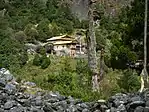
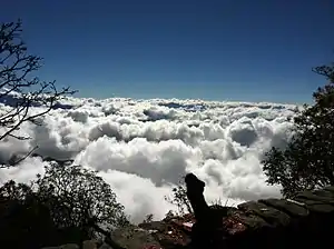
Taplejung is a best destination for trekkers. Kanchenjunga Conservation Area comprises cultivated lands, forests, pastures, rivers, high altitude lakes and glaciers. snow leopard, Asian black bear, red panda, golden-breasted fulvetta, snow cock, blood pheasant and red-billed chough can be seen in the area.[15] Pathibhara Devi Temple or Mukkumlung Manghim at Taplejung hill is considered as the home to Yuma Sammang, the deity of Limbu people and thus worshipped. A 16th century Diki Chhyoling monastery lies in Olangchung-gola.
References
- Household and population by districts, Central Bureau of Statistics (CBS) Nepal Archived 2013-07-31 at the Wayback Machine
- "Taplejung District in Nepal". Retrieved 28 March 2020.
- "Introduction DCC Taplejung". Retrieved 28 March 2020.
- "Top 5 Places to Visit in Taplejung". Retrieved 28 March 2020.
- "Indigenous voice Limbu". Retrieved 28 March 2020.
- "Taplejung". Retrieved 29 March 2020.
- "Taplejung Geography". Retrieved 29 March 2020.
- "Inventory of Sinjema-Syamdo and Timbung Pokhari". Retrieved 29 March 2020.
- "a complete guide to Nepal's rivers". Sun Koshi river trip. . Retrieved 2010-05-14.
- "Taplejung". Retrieved 29 March 2020.
- The Map of Potential Vegetation of Nepal - a forestry/agroecological/biodiversity classification system (PDF), . Forest & Landscape Development and Environment Series 2-2005 and CFC-TIS Document Series No.110., 2005, ISBN 87-7903-210-9, retrieved Nov 22, 2013
- 2011 Nepal Census, Social Characteristics Tables
- "Constituency map of Taplejung District" (PDF). Election Commission of Nepal. Retrieved 29 March 2020.
- "Taplejung". Retrieved 29 March 2020.
- Bhuju, U. R., Shakya, P. R., Basnet, T. B., Shrestha, S. (2007). Nepal Biodiversity Resource Book. Protected Areas, Ramsar Sites, and World Heritage Sites (PDF). Kathmandu: International Centre for Integrated Mountain Development, Ministry of Environment, Science and Technology, in cooperation with United Nations Environment Programme, Regional Office for Asia and the Pacific. ISBN 978-92-9115-033-5. Archived from the original (PDF) on 2011-07-26. Retrieved 2018-12-14.CS1 maint: uses authors parameter (link)
Places adjacent to Taplejung District | ||||||||||
|---|---|---|---|---|---|---|---|---|---|---|
| ||||||||||
Headquarter: Phungling | |||
 | Rural Municipalities | | |
| Municipalities | |||
| Wikimedia Commons has media related to Taplejung District. |