Rasuwa District
Rasuwa District(Nepali: रसुवा जिल्ला![]() Listen is one of 13 districts of Bagmati Province and one of seventy-seven districts of Nepal. The district, with Dhunche as its district headquarters, covers an area of 1,544 km2 (596 sq mi) and has a population (2011) of 43,300. As per census 2011 total households in Rasuwa district is 9,778. It is the smallest district by area, among 16 districts in the Himalaya region of Nepal.[1][2]
Listen is one of 13 districts of Bagmati Province and one of seventy-seven districts of Nepal. The district, with Dhunche as its district headquarters, covers an area of 1,544 km2 (596 sq mi) and has a population (2011) of 43,300. As per census 2011 total households in Rasuwa district is 9,778. It is the smallest district by area, among 16 districts in the Himalaya region of Nepal.[1][2]
Rasuwa District
रसुवा जिल्ला | |
|---|---|
District | |
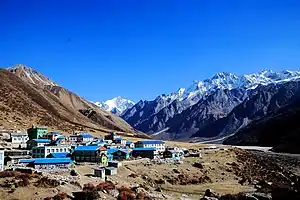 Kenzin valley of Rasuwa District | |
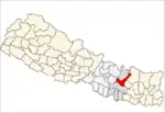
 Location of district in province | |
| Country | |
| Province | Bagmati Province |
| Established | 1962 |
| Admin HQ. | Dhunche |
| Government | |
| • Type | Coordination committee |
| • Body | DCC, Rasuwa |
| Area | |
| • Total | 1,544 km2 (596 sq mi) |
| Population (2011) | |
| • Total | 43,300 |
| • Density | 28/km2 (73/sq mi) |
| Time zone | UTC+05:45 (NPT) |
| Main Language(s) | Nepali, Tamang |
Etymology
Origin of its name had begun as 'Rasowa' which is believed to be derived as a combination of two Tibetan words ra (meaning: lambs) and sowa (meaning: grazing) as it was famous for its lamb and grazing lands. And later people started to call it Rasuwa.

Geography and climate
| Climate Zone[3] | Elevation Range | % of Area |
|---|---|---|
| Upper Tropical | 300 to 1,000 meters 1,000 to 3,300 ft. |
1.2% |
| Subtropical | 1,000 to 2,000 meters 3,300 to 6,600 ft. |
11.4% |
| Temperate | 2,000 to 3,000 meters 6,400 to 9,800 ft. |
20.8% |
| Subalpine | 3,000 to 4,000 meters 9,800 to 13,100 ft. |
20.0% |
| Alpine | 4,000 to 5,000 meters 13,100 to 16,400 ft. |
11.8% |
| Nival | above 5,000 meters | 32.9% |
| Transhimalayan[4] | Cold arid or semi-arid | 2.0% |
Its territory has elevations ranging from 614 to 7,227 meters (2,014 to 23,711 ft) from mean sea Level. Forests cover 31.43% of the land while 16.63% is always snow-covered.[6] Steeply varying territory and plenty of natural blessings make Rasuwa a famous tourist destination in Nepal. Sightseeing places including Gosaikunda Lake and Mt. Langtang plus one of the hot springs in Nepal (locally called Tatopani) are located in the district.
Demographics
At the time of the 2011 Nepal census, Rasuwa District had a population of 43,300. Of these, 67.4% spoke Tamang, 26.9% Nepali, 1.7% Tibetan, 1.1% Gurung, 0.7% Newari and 0.6% Sherpa as their first language.
63.5% of the population in the district spoke Nepali and 0.5% Tamang as their second language.[7]
Administrative divisions
The administrative division of Rasuwa comprised 5 Rural Municipalities.
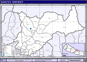
Following are five Rural Municipalities in Rasuwa District:
| # | Name | Website |
|---|---|---|
| 1 | Uttargaya Rural Municipality | uttargayamun |
| 2 | Kalika Rural Municipality | kalikamunrasuwa |
| 3 | Gosaikunda Rural Municipality | gosaikundamun |
| 4 | Naukunda Rural Municipality | naukundamun |
| 5 | Aamachhodingmo Rural Municipality | aamachhodingmomun |
Many leaders of different parties are here but only 5 mayors are here. Nepali Congress won 2 places,
CPN UML won 2 place and Rastriya Prajatantrik Party won 1 seat/place. The first ever person who
was elected in Rasuwa from Nepali Congress was Mr. Bal Chandra Poudel (2046 B.S). The history of other
parties are not commenced yet but this district in Nepal is also the one with no VDC. The winner of election
2070 bs in this district is Mr. Janarjan Dhakal.
Transportation
Rasuwa is accessible by bus from Kathmandu (national capital) via Pasang Lhamu highway (H21), with its headquarters (Dhunche) being about 120 km (75 mi) from Kathmandu. As of 2013, 3 VDCs namely Thuman, Langtang and Haku are not touched by any kind of roadway.
Tourism
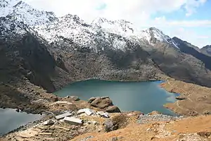
Rasuwa is rich in natural resources. Langtang mountain range stands to the north of Rasuwa. The northern parts of the area largely fall within the boundaries of Langtang National Park. Gosainkunda Lake, Ganja La Pass, and Tamang village in Bridim are the major highlights of Rasuwa for tourism. The Gosainkunda Lake, also known as "Frozen Lake", one of the most beautiful mountain lakes lies in the Langtang region. There are about 108 kundas (lakes) in this area. Saraswati Kund, Bhairab Kund, Surya Kund and Gosainkund are most important ones. Langtang valley is another attraction in Rasuwa which is aptly called the valley of glaciers; mountains rise soaring toward the sky. The valley offers pine forest, swift mountain streams, rugged rock and snow-capped peaks, grassy down and meadows strewn with daisies and wild animals.
FM radio stations
- Radio Langtang
- Radio Rasuwa
- Radio Gosainkunda
Online news portals
See also
- Hamro Rasuwa
- https://rasuwaprofile.com rasuwaprofile.com
References
- "Rasuwa". nepalmap.org. Retrieved 26 December 2020.
- "स्थानीय तहहरुको विवरण" [Details of the local level bodies]. www.mofald.gov.np/en (in Nepali). Ministry of Federal Affairs and Local Development. Retrieved 17 July 2018.
- The Map of Potential Vegetation of Nepal - a forestry/agroecological/biodiversity classification system (PDF), Forest & Landscape Development and Environment Series 2-2005 and CFC-TIS Document Series No. 110, 2005, ISBN 87-7903-210-9, retrieved Nov 22, 2013
- Shrestha, Mani R.; Rokaya, Maan B.; Ghimire, Suresh K. (2005). "Vegetation pattern of Trans-Himalayan zone in the North-West Nepal". Nepal Journal of Plant Sciences. 1: 129–135. Retrieved Feb 7, 2014.
- Banerji, Gargi; Basu, Sejuti. "Climate Change and Himalayan Cold Deserts: Mapping vulnerability and threat to ecology and indigenous livelihoods" (PDF). Pragya. Gurgaon, Haryana, India. Retrieved February 7, 2014.
- Environment Statistics of Nepal, 2011 Archived 2013-09-25 at the Wayback Machine
- 2011 Nepal Census, Social Characteristics Tables
- Rasuwa District Profile 2011
- "Districts of Nepal". Statoids.
| Wikimedia Commons has media related to Rasuwa District. |