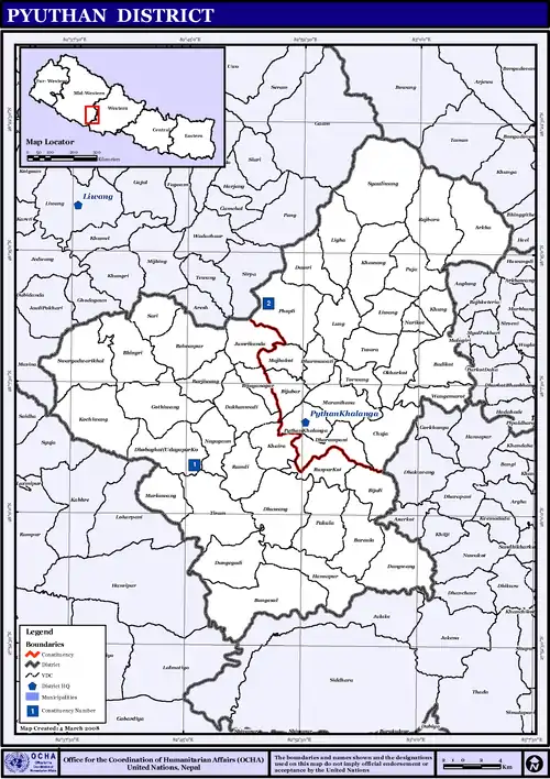
Pyuthan District
Pyuthan District(Nepali: प्युठान जिल्ला [piu̯ʈʰan] (![]() listen), is a "hill" district some 250 km (160 mi) west of Kathmandu in Lumbini Province in midwestern Nepal. Pyuthan covers an area of 1,309 km2 (505 sq mi) with population of 212,484 in 2001 and 226,796 in 2011. Pyuthan Khalanga is the district's administrative center.
listen), is a "hill" district some 250 km (160 mi) west of Kathmandu in Lumbini Province in midwestern Nepal. Pyuthan covers an area of 1,309 km2 (505 sq mi) with population of 212,484 in 2001 and 226,796 in 2011. Pyuthan Khalanga is the district's administrative center.
Pyuṭhān District
प्युठान जिल्ला | |
|---|---|
District | |
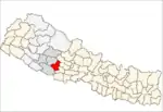
 Location of Pyuthan (dark yellow) in Lumbini Province | |
| Country | |
| Province | Lumbini Province |
| Admin HQ. | Pyuthan |
| Government | |
| • Type | Coordination committee |
| • Body | DCC, Pyuthān |
| Area | |
| • Total | 1,309 km2 (505 sq mi) |
| Population (2011)[1] | |
| • Total | 226,796 |
| • Density | 170/km2 (450/sq mi) |
| Time zone | UTC+05:45 (NPT) |
| Main Language(s) | Nepali, Newari, Khamkura |
Geography and Climate
Pyuthan borders Dang Deukhuri District to the southwest along the crest of the Mahabharat Range and extends about 50 km (31 mi) northeast through the Middle Hills to a 3,000+ meter ridge that is both Pyuthan's border with Baglung district of Dhaulagiri Zone and the main watershed between the (west) Rapti and Gandaki River basins.[2] Pyuthan borders Rolpa district to the west. Of the two upper tributaries of the West Rapti River, Pyuthan contains all of Jhimruk Khola and the lower part of Madi Khola after it exits Rolpa. The Madi-Jhimruk confluence is in southern Pyuthan, in the Mahabharat Range.[3]
The valley of Jhimruk Khola is the core of Pyuthan district. Its alluvial plain is intensively planted in rice during the summer monsoon. Wheat is grown as the winter crop. Madi Khola has eroded an inner gorge and is less suited to traditional irrigated agriculture.
| Climate Zone[4] | Elevation Range | % of Area |
|---|---|---|
| Upper Tropical | 300 to 1,000 meters 1,000 to 3,300 ft. |
36.1% |
| Subtropical | 1,000 to 2,000 meters 3,300 to 6,600 ft. |
53.3% |
| Temperate | 2,000 to 3,000 meters 6,400 to 9,800 ft. |
9.7% |
| Subalpine | 3,000 to 4,000 meters 9,800 to 13,100 ft. |
0.8% |
Demographics
At the time of the 2011 Nepal census, Pyuthan District had a population of 228,102. Of these, 96.1% spoke Nepali, 2.3% Magar and 0.7% Newari as their first language.[5]

Administrative Divisions
Pyuthan District is divided into 9 local level bodies in which two are municipalities and seven are rural municipalities:
- Municipality
- Rural Municipality
- Gaumukhi Rural Municipality
- Mandwi Rural Municipality
- Sarumarani Rural Municipality
- Mallarani Rural Municipality
- Naubahini Rural Municipality
- Jhimruk Rural Municipality
- Airawati Rural Municipality
Former VDCs
- Arkha
- (Bagdula), Bandikot, Bangemarkot, Bangesal, Baraula, Barjibang, Belbas, Bhingri, Bijaya Nagar, Bijuli, Bijuwar
- Chunja
- Dakha Kwadi, Damri, Dangbang, Dharampani, Dharmawati, Dhobaghat, Dhubang, Dhungegadhi
- Gothibang
- Hansapur
- Jumrikanda
- Khabang, Khaira, Pyuthan Municipality, Khung, Kochibang, (Kwadi)
- Libang, Ligha, Lung
- Majhakot, Maranthana, Markabang
- Narikot, Naya Gaun
- Okharkot
- Pakala, Phopli, Puja
- Rajbara, Ramdi, Raspurkot, (Ratamata)
- (Sapdanda), Sari, Swargadwarikhal, Syaulibang
- (Tikuri), Tiram, Torbang, Tusara
- (Udayapurkot)
- Pandeydada khalanga
Historic and Cultural Sites
- Airabati, Asurkot
- Bandhikot, Bhagawati Temple, Bhawaniswari Temple, Bhimsensthan, Bhimsen Temple (Kutichaur), Bhimsen Temple (Megazun), Bhimsen Temple (Bijbazar), Bhitrikot Cave, Bhitrikot Durbar, Bhringri Kot, Bhumesthan (Khaira), Bijulikot, Birdisthan
- Chhetrapal Temple
- Devi Bhagawati, Devi Bhagawati Temple, Devi Temple, Dhunge Gadhi, Dubanasthan
- Ganesh Temple, Ganeshsthan, Gaumukhi, Gorakhnath Temple (Khaira), Gorakhnath Temple (Dakha Kwadi), Gorakhnath Temple (Bijbazar)
- Jalpadevi Temple, (Bijbazar – Bhagwati), Jalpadevi Temple (Bijbazar), Jhankristhan (Khaira)
- Kalidevi Temple, Kali Temple, Kalika Malika, Khadga Devata Temple, Khalanga Shivalaya, Khungrikot
- Laxmi Narayan Temple
- Masta Mandau, Mehelnath Temple
- Okharkot
- Phalaharisthan, Pyuthan Magazine
- Radha Krishna Temple, Rameswar Temple, Rani Pauwa
- Saraswati Temple, Sarikot, Shiva Temple (Khaira),Shiva Temple (Lung), Shiva Temple (Bangeshal), Shiva Temple (Khalanga), Shivalaya, Siddha Devatasthan (Belbas), Siddha Sansarsthan (Dakha Kwadi)
- Swargadwari—a hilltop temple complex and pilgrimage site celebrating the importance of cows in Hinduism—is located in the southern part of Pyuthan.
- Tatopani Shivalaya, Tripurasundari, Tusharakot Isnasthan
- Udayapur Kot
- Pandeydada khalanga Shree Satyadevi Bhagwati Mandir, 12-bhai Baraha Dev Mandir
References
- Central Bureau of Statistics, Kathmandu, Nepal, Jan. 2014
- "Archived copy". Archived from the original on 2011-07-23. Retrieved 2010-04-22.CS1 maint: archived copy as title (link) near 28.3N latitude, 83E longitude
- "Archived copy". Archived from the original on 2011-07-23. Retrieved 2010-04-22.CS1 maint: archived copy as title (link) near 27.9N latitude, 82.9E longitude
- The Map of Potential Vegetation of Nepal - a forestry/agroecological/biodiversity classification system (PDF), Forest & Landscape Development and Environment Series 2-2005 and CFC-TIS Document Series No.110., 2005, ISBN 87-7903-210-9, retrieved Nov 22, 2013
- 2011 Nepal Census, Social Characteristics Tables
-
- "Districts of Nepal". Statoids. Gwillim Law. Retrieved January 23, 2014.
-
- National Population and Housing Census 2011, Volume 3 (PDF). Kathmandu, Nepal: Government of Nepal, Central Bureau of Statistics. January 2014. Archived from the original (PDF) on May 25, 2013. Retrieved January 23, 2014.
- Bhandari, Bishnu, ed. (1997). Inventory of heritage sites in Nepal. Kathmandu: IUCN Nepal. Archived from the original on July 21, 2011. Retrieved April 15, 2011.
External links
| Wikimedia Commons has media related to Pyuthan District. |