Tanahun District
Tanahun District (Nepali: तनहुँ जिल्ला pronounced [tʌ.nʌ.ũ] (![]() listen), or [tʌnʌɦũ]), a part of Gandaki Province, is one of the seventy-seven districts of Nepal. The district, with Damauli as its district headquarters, covers an area of 1,546 km2 (597 sq mi) and has a population (2011) of 323,288. Previously the town of Bandipur was its district headquarter. This district lies in the middlemost of country Nepal. The postal code of Tanahun is 33900.
listen), or [tʌnʌɦũ]), a part of Gandaki Province, is one of the seventy-seven districts of Nepal. The district, with Damauli as its district headquarters, covers an area of 1,546 km2 (597 sq mi) and has a population (2011) of 323,288. Previously the town of Bandipur was its district headquarter. This district lies in the middlemost of country Nepal. The postal code of Tanahun is 33900.
Tanahun District
तनहुँ | |
|---|---|
District | |
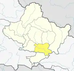 Location of Tanahun (dark yellow) in Gandaki Province | |
| Country | Nepal |
| Province | Gandaki Province |
| Established | 1872 |
| Admin HQ. | Damauli (part of Byas Municipality) |
| Government | |
| • Type | Coordination committee |
| • Body | DCC, Tanahun |
| Area | |
| • Total | 1,546 km2 (597 sq mi) |
| Population (2011) | |
| • Total | 323,288 |
| • Density | 210/km2 (540/sq mi) |
| Time zone | UTC+05:45 (NPT) |
| Telephone Code | 065 |
| Website | ddctanahu |
Bhanubhakta Acharya (Nepali: भानुभक्त आचार्य; 1814 – 1868) was a Nepalese poet and writer who translated the great epic Ramayana from Sanskrit to Khas language. His birthplace is Chundi Ramgha Tanahun Nepal. Bhanubhakta Acharya was born on 29 Ashar, 1871B.S. in Tanahun district of Nepal. Acharya was born to a Very Brahmin family and received education with a strong leaning towards religion from his grandfather at home. He is honored with the title Adikabi for the contributions he has made in the field of poetry and Khasi literature and every year, his birthday is celebrated as a festival of Bhanujayanti (29th of Ashad) by conducting various programs, usually academics and poem recitation. Chimkeswori is the highest hill of Tanahun.
Coordinates and location type
- Latitude: 27.91667
- Longitude:84.25
- Latitude (DMS):27° 55' 0 N
- Longitude (DMS):84° 15' 0 E
Geography and climate
| Climate Zone[1] | Elevation Range | % of Area |
|---|---|---|
| Lower Tropical | below 300 meters (1,000 ft) | 2.3% |
| Upper Tropical | 300 to 1,000 meters 1,000 to 3,300 ft. |
88.0% |
| Subtropical | 1,000 to 2,000 meters 3,300 to 6,600 ft. |
8.8% |
Major religious spots
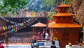
- Vyash gufa, Damauli
- Pancha mandir, Damauli
- Thanithan, Basantapur
- Teen Khole Devi Mandir, Khairenitar-8 Jamdi
- Chabdi barahi, Chabdi
- Nirjala Mai, Turture
- Akala Mai
- Aadhi Mul
- Dhorbarahi, Dhorphirdi
- Khadga Devi Mandir, Bandipur
- Devghat Tirtha isatal
- Chhimkeshwori Mai Mandir, Anbu Khaireni Rural Municipality
- Siddha Gufa/Cave, (Biggest Cave of South Asia) Bimalnagar, Dumre, Bandipur Rural Municipality
Kalika Sthan Byas 8
Demographics
At the time of the 2011 Nepal census, Tanahun District had a population of 323,288. Of these, 61.9% spoke Nepali, 20.8% Magar, 8.3% Gurung, 4.1% Newari, 1.1% Darai, 0.8% Urdu and 0.7% Tamang as their first language.
35.5% of the population in the district spoke Nepali, 0.6% Magar and 0.5% Gurung as their second language.[2]
Administration
The district consists of 10 Municipalities, out of which four are urban municipality and six are rural municipalities. These are as follows:[3]
- Bhanu Municipality
- Bhimad Municipality
- Byas Municipality
- Shuklagandaki Municipality
- Anbu Khaireni Rural Municipality
- Devghat Rural Municipality
- Bandipur Rural Municipality
- Rishing Rural Municipality
- Ghiring Rural Municipality
- Myagde Rural Municipality
Former Village Development Committees
Prior to the restructuring of the district, Tanahun District consisted of the following municipalities and Village development committees:
- Anbu Khaireni Municipality
- Arunodaya
- Baidi
- Bhanumati
- Bhirkot
- Bhirlung
- Chhang
- Chhimkeshwari
- Chhipchhipe
- Chok Chisapani
- Deurali
- Dharampani
- Gajarkot
- Ghansikuwa
- Jamune Bhanjyang
- Kabilas
- Kahu Shivapur
- Keshavtar
- Kihun
- Kota
- Kotdarbar
- Kyamin9 vyas marg damouli to pattal
- Majhakot
- Manpang
- Phirphire
- Purkot
- Raipur
- Ramjakot
- Ranipokhari
- Risti
- Rupakot
- Satiswara
- Sundhara
- Syamgha
- Tanahunsur
- Thaprek
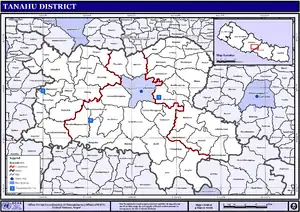
Map Of Tanahun
See also
- Western Region Campus
- Bhanubhakta Acharya
- Nara Nath Acharya
- Bandipur: The Queen of Hills of Nepal
References
- The Map of Potential Vegetation of Nepal - a forestry/agroecological/biodiversity classification system (PDF), Forest & Landscape Development and Environment Series 2-2005 and CFC-TIS Document Series No.110., 2005, ISBN 87-7903-210-9, retrieved Nov 22, 2013
- 2011 Nepal Census, Social Characteristics Tables
- "स्थानिय तह" (in Nepali). Ministry of Federal Affairs and General Administration. Retrieved 1 September 2018.
- "Districts of Nepal". Statoids.
| Wikimedia Commons has media related to Tanahu District. |
Headquarters: Damauli (today part of Byas Municipality) | ||
| Municipalities | 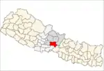 | |
| Rural municipalities | ||
| Former VDCs |
| |