Eastern Rukum District
Eastern Rukum (Nepali: पूर्वी रुकुम) is a mountain district located in the Lumbini Province of Nepal. It is one of the twelve districts of the province [1] and contains over sixty percent of Dhorpatan Hunting Reserve in the western section of Dhaulagiri mountain range.[2] It is also the only mountain-district of the province with its tallest mountain Putha Hiunchuli (Dhaulagiri VII) situated in the west end of Dhaulagiri II mountain chain, at an elevation of 7,246 meters.[3] Eastern Rukum has been included as one of "Nepal´s top 100 travel destinations" by the Government of Nepal.[4]
Eastern Rukum District
पूर्वी रुकुम | |
|---|---|
District | |
 | |
 Location of the district (dark yellow) in Lumbini Province | |
| Coordinates: 28.37°N 82.37°E | |
| Country | |
| Province | Lumbini Province |
| Established | 2015 |
| Admin HQ. | Rukumkot |
| Government | |
| • Type | Coordination committee |
| • Body | DCC, Eastern Rukum |
| Area | |
| • Total | 1,161.13 km2 (448.31 sq mi) |
| Population | |
| • Total | 53,018 |
| • Density | 46/km2 (120/sq mi) |
| Time zone | UTC+05:45 (NPT) |
| Website | dccrukumeast |
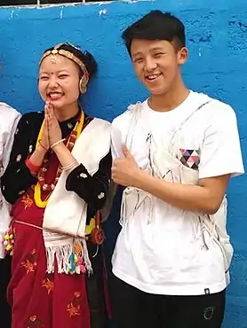
The district is known for its 52 lakes and 53 hills. From 1996 to 2006, Eastern Rukum was the heartland of the decade-long People´s War of Nepal (Nepalese Civil War) providing many foot soldiers, commanders, prominent leaders and martyrs during the war. Guerilla trekking route has also been developed in the district as an adventure tourism following the past trails of the Maoist rebels in the base of Himalayas providing experiences of scenic landscapes, Dhaulagiri mountain ranges and rich Kham Magars culture.[5][6]
Rukumkot is the interim headquarter of the district. There was a decision of government to relocate the district headquarter from Rukumkot to Golkhada, Kol, Putha Uttarganga,[7] albeit not finalized until now. Formerly, Eastern Rukum District was part of Rukum District, which was split into two districts Western Rukum and Eastern Rukum after the state's reconstruction of administrative divisions as of 20 September 2015. Though successful in maintaining various levels of autonomy, independence and preservation of Kham Magar culture even during ancient and medieval Nepal, the region´s structure were altered during the aristocracy of Rana dynasty as well as during Panchayat (Nepal). Before 1975, substantial portion of Eastern Rukum was territorially merged with Palpa district during Rana dynasty and with Baglung District during the state reconstruction of Shah Dynasty[8][9] respectively.
History
Early history
Himalayas has been a melting pot of diverse tribes and cultures after the periods of early human migrations of homo-sapiens. Presence of highly-rich Magar culture with a complex of Kham Magar language of Tibeto-Burman Languages family suggests that the region was along the ancient migration routes of tribes out of Tibet. In addition to this, being on the northern corridor of the Indian sub-continent, the region was also on the radius of the Indus valley civilization and influences of various warring tribes and empires such as Kirata Kingdom, Kushan Empire (Ancient Greek: Βασιλεία Κοσσανῶν), Gupta Empire, Maurya Empire, Nanda Empire, Karkota Empire, Utpala dynasty, and Khasa Kingdom.[10] After the initial Muslim conquests spanning out of Arabian lands, western Himalayas also served as the refuge and protection to numerous non-Muslim tribes fleeing their homelands in Persia, Afghanistan (Oxiana), Sindh, Kashmir and northern India who assimilated themselves among the locals .[11] The Khas language (of Indo-European languages family) of the Khasa Kingdom later became the lingua Franca of Nepal after national unification. With east-west Dhorpatan valley south of the Himalayas, eastern Rukum was also a historic migration route and crossroad for these tribes to move eastwards.
Modern history
With the conquest of the district as a part of the national unification campaign, the region was merged with the kingdom of Nepal during the time of Bahadur Shah of Nepal and Rana Bahadur Shah (1777-1799). Though successful in maintaining various levels of autonomy, independence and preservation of Kham Magar culture even during ancient and medieval Nepal, the region´s structure were altered during the aristocracy of Rana dynasty as well as during Panchayat (Nepal). Before 1975, substantial eastern portion was territorially merged with Palpa district during Rana dynasty and with Baglung District or Dolpa District during the state reconstruction during Shah Dynasty[8][9] respectively. Formerly, Eastern Rukum District was part of Rukum District, which was split into two districts western and Eastern Rukum after the state's reconstruction of administrative divisions as of 20 September 2015.
During the centuries long Shah dynasty and Rana Dynasty rule of Nepal, numerous young women of this region were made Queens (Bada Maharani) and wives of the dynasties through royal marriages, locally known as "Dola Palne" tradition:[12] Queen Purna Kumari Devi,[13] the wife of a Rana Prime Minister; Queen Karma Kumari Devi, the wife of Prime Minister Dev Shumsher Jang Bahadur Rana and foster mother of Prime Minister Juddha Shumsher Jang Bahadur Rana,[12] as well as son-in-laws for the royalties such as in the case of Shova Rajya Lakshmi Devi (Princess Shova Shahi of Nepal), the sister of King Birendra of Nepal and the youngest daughter of king Mahendra of Nepal, among others.

Researchers point out that due to lasting feudalism, aristocracy, social inequality and slow development within the district, there was a growing dissatisfaction of the larger public towards the nobles.[14] As a result, eastern Rukum became some of the earliest communist stronghold of the country during the 20th century.[15] Not surprisingly, it also became the heartland of Nepalese Civil War (Maoist revolution) against land inequality, ethnic inequality, feudalism and aristocracy from 1996 till 2006, ultimately resulting in the end of 240 year old Monarchy and turning of the country into a democratic Federal republic.

Division & Population
The total area of Eastern Rukum District is 1,161.13 square kilometres (448.31 sq mi) and total population of this district as of 2011 Nepal census is 53,018 individuals.[1][16] The district is divided into 3 Rural Municipalities and there is a large reserve area named Dhorpatan Hunting Reserve.[1][17][16] There is no Municipality in this district.


Division of the rurual municipalities of Eastern Rukum:
| Name | Nepali | Population (2011) | Area (km2) | Density |
|---|---|---|---|---|
| Bhume | भूमे | 18,589 | 273.67 | 68 |
| Putha Uttarganga | पुथा उत्तरगंगा | 17,932 | 560.34 | 32 |
| Sisne | सिस्ने | 16,497 | 327.12 | 50 |
Demographics
Magars make up the majority of the population in Eastern Rukum.[18] After Palpa district (53% Magar population), Eastern Rukum has the second-largest Magar population in Nepal as a percentage of the total population (51%), followed by Rolpa (43%). The table highlights the demographics of the district (National Data Profile:2020).[18]
| Demographics | Percentage |
|---|---|
| Magars | 51% |
| Chhetris | 19% |
| Kamis | 17% |
| Thakuris | 4% |
| Damai/Dholi | 3% |
| Brahmins-hill | 2% |
| Gurung | 1% |
| Newar | 1% |
| Sarki | 1% |
| Others | 1% |
Climate & Geography


Eastern Rukum district is the northernmost part of Lumbini Province, and its only mountain district. Most of the district is drained by west-flowing tributaries such as Uttar Ganga draining Dhorpatan Valley and to the north of that the Sani Bheri draining southern slopes of the western Dhaulagiri Himalaya.
Elevation may range upto 6,000 meters in the Dhaulagiri with a range of climates from sub-tropical to perpetual snow and ice. Agricultural use ranges from irrigated rice cultivation through upland cultivation of maize, barley, wheat, potatoes and fruit, to sub-alpine and alpine pasturage reaching about 4,500 meters.
The climatic condition of the district can be classified into six types:
| Climate Zone | Elevation Range |
|---|---|
| Upper Tropical | 300 to 1,000 meters |
| Subtropical | 1,000 to 2,000 meters |
| Temperate | 2,000 to 3,000 meters |
| Subalpine | 3,000 to 4,000 meters |
| Alpine | 4,000 to 5,000 meters |
| Nival | above 5,000 meters |
Dhaulagiri Mountains
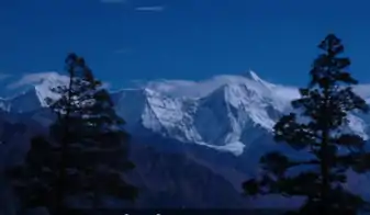
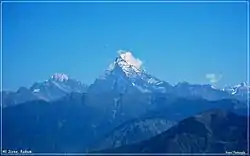
Among many mountains of the district, the most famous peaks are Mount Putha and Mount Sisne. Mount Putha is also the tallest mountain of Lumbini Province situated in the west end of Dhaulagiri II mountain chain, at an elevation of 7,246 meters. It was first climbed in 1954 by J. O. M. Roberts and Ang Nyima Sherpa.[19]
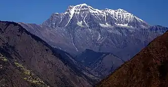
Another prominent mountain is Mount Sisne at the north. Locally known as Mount Patan (Hiunchuli Patan), Sisne or Murkatta Himal, the mountain has an elevation of 5,849 meters.
Mount Sisne was frequently featured in the literatures of civil war, as a symbol of the people´s revolution and became an iconic landmark to revolutionaries during the 1996–2006 Nepal Civil War. In 2013, the mountain was first successfully ascended by a Nepalese expedition led by Man Bahadur Khatri.[20]
The following are the prominent peaks of the district:
• Mount Putha। (Location : Dhaulagiri)
• Mount Putha ।। (Location : Dhaulagiri)
• Mount Sisne । (Location : Dhaulagiri)
• Mount Sisne ।। (Location : Dhaulagiri)
• Mount Dogari (Location : Dhaulagiri)
• Mount Samjang (Location : Dhaulagiri)
• Mount Nimku (Location : Dhaulagiri)
Lakes and Rivers
With 52 lakes in Rukumkot alone, the district has substantial quantity of water bodies and rivers in proportion to its size. Most of the district is drained by west-flowing tributaries such as Uttar Ganga draining Dhorpatan Valley and to the north of that the Sani Bheri draining southern slopes of the western Dhaulagiri Himalaya.

Among many lakes, Rukmini Lake has been the centerpeice in the district. Named after Rukmini, the consort of Krishna, Rukmini Lake also known as Lotus Lake (Nepali: Kamal Taal) because of its fullness with lotus flowers (Nelumbo nucifera). The lake holds a religious and sacred importance to the locals due to which huge gathering occurs during the festivals of Maha Shivaratri, Dashain, Maghe Sankranti and Haritalika Teej.

Guerilla Trek
Guerilla trek is an tourism adventure-track following the trails of guerillas (maoist revolutionaries) during the 10 year´s war (Nepalese Civil War) against the government, in their rebel heartland, in the majority Magars villages. Trekkers can retrace the route of the fighters in this district as well as neighbouring northern Rolpa District, Baglung District and Myagdi District and experience traditional Magar culture.[21]


The trek normally begins at Beni of Gandaki Province, a four to five hour bus ride from Pokhara then passes through various villages of Myagdi and Baglung and then into eastern Rukum.
Other important tracks of the route are Chunwang, the landmark meeting place of the party leadership in eastern Rukum and Thabang (6480 ft, 1975 m), the cradle of the war where the Maoists had almost unanimous support and which suffered some of the heaviest fighting during the war.[6]
See also
References
- "स्थानीय तहहरुको विवरण" [Details of local level body]. www.mofald.gov.np (in Nepali). Ministry of Federal Affairs and Local Development (Nepal). Retrieved 8 April 2018.
- "कान्छो जिल्लाको तोतेबोलीः किन टुक्रियो पूर्वी रुकुम ?". Online Khabar. Retrieved 22 October 2020.
- "रुकुम (पूर्वी भाग) जि.स.स". dccrukumeast.gov.np. Retrieved 22 October 2020.
- "Visit Nepal 2020 | Destinations for visit Nepal 2020". Nepal Guide Treks & Expedition - Hiking & Peak Climbing Agency. 5 January 2020. Retrieved 22 October 2020.
- "RAOnline Nepal: Trekkings in Nepal - New Trekking routes in Nepal - Guerrilla tourist trail launched". www.raon.ch. Retrieved 22 October 2020.
- "The Guerilla Trek". ECS NEPAL. Retrieved 22 October 2020.
- "Decision on East Rukum HQ stayed". www.thehimalayantimes.com. The Himalayan Times. 2 February 2018. Retrieved 8 April 2018.
- RUKUM, TAKASERA EASTERN (31 January 2018). "विकटता र निकटता ……". Medium. Retrieved 22 October 2020.
- "रुकुमपूर्व जिल्लाको सदरमुकाम गोल्खाडा नै हुनुपर्ने माग". Sansar News- Online for Global Nepali. 10 February 2020. Retrieved 22 October 2020.
- "A". personal.carthage.edu. Retrieved 24 October 2020.
- "Nepal - Caste and Ethnicity". countrystudies.us. Retrieved 24 October 2020.
- "THE RANI FROM RUKUM - Think Research Expose | Think Research Expose". Retrieved 22 October 2020.
- "Rukumkot- Town of ponds and hills". Nepal Travel Guide. 30 May 2020. Retrieved 22 October 2020.
- Shah, Alpa; Pettigrew, Judith (11 December 2009). "Windows into a revolution: ethnographies of Maoism in South Asia". Dialectical Anthropology. 33 (3): 225. doi:10.1007/s10624-009-9142-5. ISSN 1573-0786.
- de Sales, Anne (2009). "From ancestral conflicts to local empowerment: two narratives from a Nepalese community". Dialectical Anthropology. 33 (3/4): 365–381. ISSN 0304-4092.
- "CITY POPULATION– statistics, maps & charts". www.citypopulation.de. 8 October 2017. Retrieved 4 April 2018.
- "District Corrected Last for RAJAPATRA" (PDF). www.mofald.gov.np. Ministry of Federal Affairs and Local Development (Nepal). Retrieved 4 April 2018.
- "NepalMap profile: Rukum East". NepalMap. Retrieved 22 October 2020.
- "Putha Hiunchuli Climbing". www.asianhikingteam.com. Retrieved 22 October 2020.
- "Sisne Climbing | Western Nepal Treks". www.westernnepaltreks.com. Retrieved 22 October 2020.
- Rana, Surendra (2018). Guerrilla Trail: A Tourism Product in the Maoist Rebel's Footsteps. Projects: Reintegration of ex-combatantsDark Tourism in NepalPeace building in Nepal.