Ramechhap District
Ramechhap District (Nepali: रामेछाप जिल्ला![]() Listen ), a part of Bagmati Province, is one of the seventy-seven districts of Nepal, a landlocked country of South Asia. The district, known as Kirat Ramechhap, with Manthali as its district headquarters, covers an area of 1,546 km2 (597 sq mi) and has a population (2011) of 202,646[1] and a density of 137.4 per km2.
Listen ), a part of Bagmati Province, is one of the seventy-seven districts of Nepal, a landlocked country of South Asia. The district, known as Kirat Ramechhap, with Manthali as its district headquarters, covers an area of 1,546 km2 (597 sq mi) and has a population (2011) of 202,646[1] and a density of 137.4 per km2.
Ramechhap District
रामेछाप | |
|---|---|
District | |
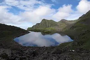 Panch Pokhari at Ramechhap | |
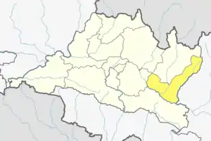 Location of district in province | |
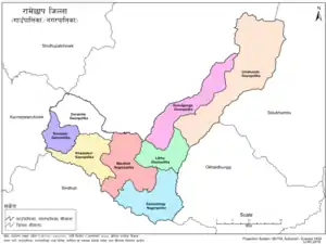 Ramechhap with local level body | |
| Country | |
| Province | Bagmati Province |
| Admin HQ. | Manthali |
| Government | |
| • Type | Coordination committee |
| • Body | DCC, Ramechhap |
| Area | |
| • Total | 1,546 km2 (597 sq mi) |
| Population (2011)[1] | |
| • Total | 202,646 |
| • Density | 130/km2 (340/sq mi) |
| Time zone | UTC+05:45 (NPT) |
| Main Language(s) | Nepali, Sunuwar, Tamang, Newari and Haayu |
| Website | www |
According to LLRCNepal[2] there are now eight local administrations in the district: Manthali Municipality, Ramechhap Municipality, Umakunda Rural Municipality, Khandadevi Rural Municipality, Gokulganga Rural Municipality, Doramba Rural Municipality, Likhu Rural Municipality and Sunapati Rural Municipality.[3]
The district has the highest population of the endangered native group the Kusunda and has the lowest population growth rate in Nepal.[4]
Etymology
The district was named after Ramechhap village. The word Ramechhap comes from two Nepali words, Ram (person's name) and Chhap (mark). According to folklore, the village of Ramechhap was once occupied by Tamang people. A Tamang of the village, Ram by name received mukhtiyari of the village by royal decree. So, the land ownership and other legal activities were performed in the village by the stamp (chhap) of Ram.
Similarly, according to another folklore, the grassland of Ramechhap village was occupied by Tamang people. Those people daily used to rear their domesticated animals such as Buffalo, Goat and others in the open meadow. In Tamang language, "Ra" means Goat, "Mey" means ox, and "Chhawa" means their small offspring. By the time and mouth to mouth pronunciation the meadow has become "Ramechhap" and later the place has been named Ramechhap. Hence, the district is called Ramechhap.[5]
Geography and climate
| Climate Zone[6] | Elevation Range | % of Area |
|---|---|---|
| Upper Tropical | 300 to 1,000 meters 1,000 to 3,300 ft. |
18.0% |
| Subtropical | 1,000 to 2,000 meters 3,300 to 6,600 ft. |
42.1% |
| Temperate | 2,000 to 3,000 meters 6,400 to 9,800 ft. |
21.0% |
| Subalpine | 3,000 to 4,000 meters 9,800 to 13,100 ft. |
6.7% |
| Alpine | 4,000 to 5,000 meters 13,100 to 16,400 ft. |
3.6% |
| Nival | above 5,000 meters | 7.3% |
Demographics
At the time of the 2011 Nepal census, Ramechhap District had a population of 202,646. Of these, 59.5% spoke Nepali, 18.2% Tamang, 6.9% Newari, 5.1% Sherpa, 3.7% Sunuwar, 2.1% Majhi, 2.0% Magar, 1.0% Thami and 0.5% Hyolmo/Yolmo as their first language.
35.5% of the population in the district spoke Nepali and 0.5% Bahing as their second language.[7]
Old Village Development Committees (VDCs)
- Bamti Bhandar
- Betali
- Bethan
- Bhirpani
- Bhuji
- Bijulikot
- Chisapani Municipality
- Chanakhu
- Chuchure
- Dadhuwa
- Duragaun
- Deurali
- Dimipokhari
- Doramba
- Duragau
- Gagal Bhadaure
- Gelu
- Goswara
- Gothgau
- Gumdel
- Gunsi Bhadaure
- Gupteshwar
- Hiledevi
- Himganga
- Khandadevi
- Khaniyapani
- Khimti
- Kumbukasthali
- Lakhanpur
- Majuwa
- Makadum
- Manthali Municipality
- Naga Daha
- Namadi
- Pakarbas
- Pharpu
- Phulasi
- Piukhuri
- Priti
- Puranagau
- Rakathum
- Ramechhap Municipality
- Rampur
- Rashnailu
- Saipu
- Sanghutar
- Those
- Tilpung
- Tokarpur
Newly formed local administrative bodies
| Name | Nepali | Population (2011) | Area (km2) | Density |
|---|---|---|---|---|
| Manthali Municipality | मन्थली नगरपालिका | 213 | ||
| Ramechhap Municipality | रामेछाप नगरपालिका | 203 | ||
| Umakunda Rural Municipality | उमाकुँण्ड गाउँपालिका | 451 | ||
| Khandadevi Rural Municipality | खाँडादेभी गाउँपालिका | 151 | ||
| Doramba Rural Municipality | दोरम्वा गाउँपालिका | 141 | ||
| Gokulganga Rural Municipality | गोकुलगँगा गाउँपालिका | 197 | ||
| Likhutamakoshi Rural Municipality | लिखु तामाकोशी गाउँपालिका | 125 | ||
| Sunapati Rural Municipality | सुनापति गाउँपालिका | 85 |
See also
References
- Household and population by districts, Central Bureau of Statistics (CBS) Nepal Archived 2013-07-31 at the Wayback Machine
- District Profile of Ramechhap at Central Bureau of Statistics, Nepal website (in Nepali) Archived 2009-04-30 at the Wayback Machine
- Book: Ramechhap:Introduction, Publication: District Development Committee, Ramechhap, Language: Nepali
- The Map of Potential Vegetation of Nepal - a forestry/agroecological/biodiversity classification system (PDF), Forest & Landscape Development and Environment Series 2-2005 and CFC-TIS Document Series, No. 110, 2005, ISBN 87-7903-210-9, retrieved Nov 22, 2013
- 2011 Nepal Census, Social Characteristics Tables
External links
- "Districts of Nepal". Statoids.
 Ramechhap travel guide from Wikivoyage
| Wikimedia Commons has media related to Ramechhap District. |
Headquarters: Manthali | ||
| Municipalities | 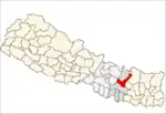 | |
| Rural municipalities | ||
| Former VDCs |
| |