Dhading District
Dhading District (Nepali: धादिङ जिल्ला ![]() Listen ), a part of Bagmati Province, is one of the seventy-seven districts of Nepal. The district, with Dhading Besi as its district headquarters, covers an area of 1,926 square kilometres (744 sq mi), had a population of 338,658 in 2001[2] and 336,067 in 2011.[1]
Listen ), a part of Bagmati Province, is one of the seventy-seven districts of Nepal. The district, with Dhading Besi as its district headquarters, covers an area of 1,926 square kilometres (744 sq mi), had a population of 338,658 in 2001[2] and 336,067 in 2011.[1]
Dhading District
धादिङ जिल्ला | |
|---|---|
District | |
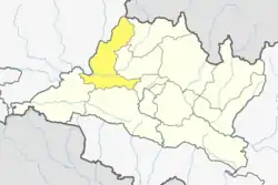 Location of District in Bagmati Pradesh | |
| Country | |
| Province | Bagmati Province |
| Admin HQ. | Dhading Besi |
| Government | |
| • Type | Coordination committee |
| • Body | DCC, Dhading |
| Area | |
| • Total | 1,926 km2 (744 sq mi) |
| Population (2011)[1] | |
| • Total | 336,067 |
| • Density | 170/km2 (450/sq mi) |
| Time zone | UTC+05:45 (NPT) |
| Website | www |
Geography and climate
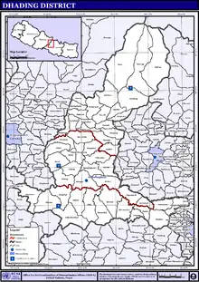
Dhading district spreads from 27'40" E to 28'17" E and 80'17"N to 84'35"N.[3] The mountain range Ganesh Himal is the predominate mountain range located within Dhading. Some of the peaks are over 7,000 metres (23,000 ft). The 8,000-metre (26,000 ft) plus mountain Manaslu is clearly visible from much of Dhading, although it is located within the bounds of Gorkha. The transnational Prithivi Highway connecting Kathmandu and Pokhara runs through the southern portion of the district making for easy access to the Kathmandu valley. The road parallels the Trishuli River. The western border with Gorkha is bisected by the Budhigandaki River.
The district is bounded by
- East: Kathmandu, Rasuwa and Nuwakot
- West: Gorkha
- North: Rasuwa and Tibet
- South: Makwanpur and Chitwan
Dhading is the only district of Nepal which ranges from the mountain Ganesh Himal to the Churevawar pradesh of Terai (Chitwan). The district, with Dhading Besi as its district headquarters, covers an area of 1,926 square kilometres (744 sq mi) and has a population (2001) of 338,658.[2] The mountain range "Ganesh" is the predominated mountain range located within Dhading. All of the peaks are over 7,000 metres (23,000 ft) with some approaching 8,000 metres (26,000 ft). The 8,000-metre (26,000 ft) plus mountain "Manaslu" is clearly visible from much of Dhading, although it is located within the bounds of Gorkha. The transnational "King Prithivi Highway" connecting Kathmandu and Pokhara runs through the southern portion of the district making for easy access too the Kathmandu valley. The road parallels the Trishuli River. Dhading is 80% farmland and 20% forest. The western border with Gorkha is bisected by the Budhigandaki River, one of the prettiest rivers of Nepal.
| Climate Zone[4] | Elevation Range | % of Area |
|---|---|---|
| Upper Tropical | 300 to 1,000 meters 1,000 to 3,300 ft. |
39.7% |
| Subtropical | 1,000 to 2,000 meters 3,300 to 6,600 ft. |
35.1% |
| Temperate | 2,000 to 3,000 meters 6,400 to 9,800 ft. |
10.8% |
| Subalpine | 3,000 to 4,000 meters 9,800 to 13,100 ft. |
7.7% |
| Alpine | 4,000 to 5,000 meters 13,100 to 16,400 ft. |
3.2% |
| Nival | above 5,000 meters | 2.5% |
The people of the district are primarily Bhramin and Chetri in the south and Tamang and Gurung in the north, with much of the center Newari. Gurkha route, the birthplace of founder of Nepal King Prithivi Naryan Shah crosses through Dhading.
Rivers
The main river of the Dhading district is Budi Gandaki which comes from Ganesh Himal and passes through Arughat Bazaar and Salyantar and meets Ankhu khola at Narsingha Dhamm. Budhi Gandaki separates the district from Gorkha district. There are 25 small rivers, the main being Charoudi, Malekhu, Galtukhola, Belkhukhola, Chirandikhola, Maheshkhola, Thopal, Manukhola, Kastekhola, Mastekhola. Besides these, there are over 1743 smaller rivers, springs and seasonal streams.[5]
Demography
At the time of the 2011 Nepal census, Dhading district had a population of 336,067. Of these, 70.6% spoke Nepali, 19.9% Tamang, 2.5% Chepang, 2.1% Gurung, 1.9% Magar, 0.9% Newari, 0.7% Ghale and 0.5% Kumal as their first language.
25.5% of the population in the district spoke Nepali, 0.5% Tamang and 0.5% English as their second language.[6]
The people of the district are primarily Brahmin and Chhetri in the south and Ghale, Gurung and Tamang in the north, with much of the center Newari.
Religious temple
Dhading District has many religious temples. Among them is Tripurasundari Mai which lies in the northern part of the district. Siddha than in Siddhalekh Rural Municipality is a Hindu religious site. Others are Bhairabi Temple in Sunaula Bazar. Sri Nrsimha Dham Kshetra in Salyantar is a historical religious site for vedic sanatan Hindu people, where Jagannath Foundation - Sri Rupanuga Para Vidyapeeth, Bimala Devi temple, Shesa Temple, Sada Shiva and ancient Nrsimha Deva temple, and Ganga Jamuna temple are attraction. Kot Devi is a religious place in Jwalamukhi Rural Municipality, Maidi.
Administration
Dhanding district consists of 2 municipalities and 11 rural municipals.
Municipalities
Towns and villages
- Aginchok
- Baireni
- Baseri
- Benighat
- Bhumesthan
- Budhathum
- Chainpur
- Chhatre Dyaurali
- Dangsing
- Darkha
- Dhola
- Dhusha
- Dhuwakot
- Gajuri
- Gaunkharka
- Gerkhu
- Ghussa
- Goganpani
- Gumdi
- Jharlang
- Jiwanpur
- Jogimara
- Jyamaruk
- Kalleri
- Katunje
- Kebalpur
- Khalte
- Khari
- Kiranchok
- Kumpur
- Lapa
- Mahadevsthan
- Maidi
- Marpak
- Mulpani
- Murali Bhanjyang
- Nalang
- Naubise
- Nilkantha Municipality
- Phulkharka
- Pida
- Ranibari
- Rigaun
- Salang
- Salyankot
- Salyantar
- Sangkosh
- Satyadevi
- Semjong
- Sirtung
- Sukabhanjyang
- Sunaula Bazar
- Tasarphu
- Thakre
- Tipling
- Tripureshwar
See also
References
- "National Population and Housing Census 2011(National Report)" (PDF). Central Bureau of Statistics. Government of Nepal. November 2012. Archived from the original (PDF) on 2013-04-18.
- "Nepal Census 2001". Nepal's Village Development Committees. Digital Himalaya. Archived from the original on 12 October 2008. Retrieved 12 December 2008.
- "District Development Committee, Dhading".
- The Map of Potential Vegetation of Nepal - a forestry/agroecological/biodiversity classification system (PDF), Forest & Landscape Development and Environment Series 2-2005 and CFC-TIS Document Series No.110., 2005, ISBN 87-7903-210-9, retrieved Nov 22, 2013
- Book:Jilla Bastugat Biwaran:Dhading-2064, Page 3, Language: Nepali, Nepal Government Publication
- 2011 Nepal Census, Social Characteristics Tables
External links
Headquarter: Dhading Besi | ||
| Gaupalika |  | |
| Municipalities | ||
| Wikimedia Commons has media related to Dhading District. |