Okhaldhunga District
Okhaldhunga District (Nepali: ओखलढुङ्गा जिल्ला![]() Listen ) is one of 14 districts of Province No. 1 in eastern Nepal. The district, with Okhaldhunga as its district headquarters, covers an area of 1,074.5 km2 (414.9 sq mi) and had a population of 156,702 in 2001 and 147,984 in 2011.[1]
Listen ) is one of 14 districts of Province No. 1 in eastern Nepal. The district, with Okhaldhunga as its district headquarters, covers an area of 1,074.5 km2 (414.9 sq mi) and had a population of 156,702 in 2001 and 147,984 in 2011.[1]
Okhaldhunga District
ओखलढुङ्गा जिल्ला | |
|---|---|
District | |
 Kosh Bhanjyang, Okhaldhunga | |
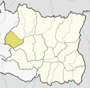 Location of Okhaldhunga in dark yellow | |
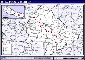
 Okhaldhunga District with local level body | |
| Country | |
| Province | Province No. 1 |
| Admin HQ. | Siddhicharan Municipality |
| Government | |
| • Type | Coordination committee |
| • Body | DCC, Okhaldhunga |
| Area | |
| • Total | 1,074 km2 (415 sq mi) |
| Population (2011) | |
| • Total | 147,984 |
| • Density | 140/km2 (360/sq mi) |
| Time zone | UTC+05:45 (NPT) |
| Main Language(s) | Nepali language (official) Rai, Sunuwar language |
| Website | ddcokhaldhunga |
Okhaldhunga is the place where Siddhicharan Shrestha and was born. Siddhicharan Shrestha is known as the 'Yug Kawi (युगकवी)' of Nepal.

Geography and climate

| Climate Zone[2] | Elevation Range | % of Area |
|---|---|---|
| Upper Tropical | 300 to 1,000 meters 1,000 to 3,300 ft. |
22.2% |
| Subtropical | 1,000 to 2,000 meters 3,300 to 6,600 ft. |
51.1% |
| Temperate | 2,000 to 3,000 meters 6,400 to 9,800 ft. |
24.2% |
| Subalpine | 3,000 to 4,000 meters 9,800 to 13,100 ft. |
2.1% |
Demographics
At the time of the 2011 Nepal census, Okhaldhunga District had a population of 147,984. Of these, 57.9% spoke Nepali, 9.2% Tamang, 8.9% Magar, 6.8% Sherpa, 4.8% Wambule, 3.8% Bahing, 2.1% Sunuwar, 1.9% Rai, 1.1% Newari, 1.0% Jero/Jerung and 0.5% Bhojpuri as their first language.
35.8% of the population in the district spoke Nepali and 1.4% Jero/Jerung, 0.6% Bahing as their second language.[3]
Village Development Committees
The district contains the following VDCs from 2017:
Andheri Narayansthan, Baksa, Balakhu, Barnalu, Baruneshwor, Betinee, Bhadaure, Bhussinga, Bigutar, Bilandu, Chyanam, Diyale, Fediguth, Fulbari, Gamnangtar, Harkapur, Jantarkhani, Jyamire, Kalikadevi, Khijikati, Katunje, Ketuke, Khiji Chandeshwori, Khijifalate, Kuibhir, Kuntadevi, Madhavpur, Mamkha, Manebhanjyang, Moli, Mulkharka, Narmedeshwor, Okhaldhunga, Palapu, Patle, Pokali, Pokhare, Prapcha, Ragadip, Ragani, Raniban, Ratmate, Rawadolu, Rumjatar, Salleri, Serna, Shreechaur, Singhadevi, Sisneri, Taluwa, Tarkerabari, Thakle, Thoksela, Thulachhap, Ubu, Yasam
Municipality
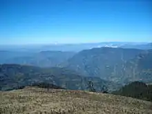
Tourist area
Khijee Tholedamba Tourists are attracted towards the beauty of Khiji Okhaldhunga.
Tourist area
Betinee Thuldhunga Tourists are attracted towards the beauty of Betinee Thuldhunga Okhaldhunga.
See also
References
- Household and population by districts, Central Bureau of Statistics (CBS) Nepal Archived July 31, 2013, at the Wayback Machine
- The Map of Potential Vegetation of Nepal - a forestry/agroecological/biodiversity classification system (PDF), Forest & Landscape Development and Environment Series 2-2005 and CFC-TIS Document Series No.110., 2005, ISBN 87-7903-210-9, retrieved Nov 22, 2013
- 2011 Nepal Census, Social Characteristics Tables
- "Districts of Nepal". Statoids.
| Wikimedia Commons has media related to Okhaldhunga District. |
Places adjacent to Okhaldhunga District | ||||||||||
|---|---|---|---|---|---|---|---|---|---|---|
| ||||||||||
Headquarter: Okhaldhunga | ||
| Urban Municipality | | |
| Rural Municipality | ||