Rolpa District
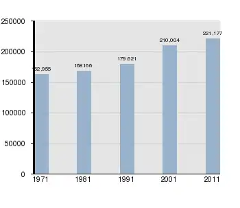
Rolpa (Nepali: रोल्पा जिल्ला)![]() Listen , is a "hill" district in Lumbini Province of Nepal. Rolpa district covers an area of 1,879 km2 (725 sq mi) with population (2011) of 221,177. Rolpa town is the district's administrative center.
Listen , is a "hill" district in Lumbini Province of Nepal. Rolpa district covers an area of 1,879 km2 (725 sq mi) with population (2011) of 221,177. Rolpa town is the district's administrative center.
Rolpa District
रोल्पा | |
|---|---|
District | |
 Location of Rolpa (dark yellow) in Lumbini Province | |
| Country | |
| Province | Lumbini Province |
| Established | 13 April 1961 |
| Admin HQ. | Rolpa |
| Government | |
| • Type | Coordination committee |
| • Body | DCC, Rolpa |
| Population (2015)[1] | |
| • Total | 221,178 |
| Time zone | UTC+05:45 (NPT) |
| Main Language(s) | Nepali, Khamkura, Newari, English |
| Website | ddcrolpa |
The various grievances of Rolpa's population made the district ripe for revolt. It became a "Maoist Stronghold" of the Communist Party of Nepal.[2] In May 2002 a major battle between Maoist guerillas and the army was fought at Lisne Lekh near the Rolpa-Pyuthan border.
History
The area of Rolpa District was under the Rukumkot (Rukum District) King before 15th century. Tuthansen (King of Salyankot) established a separate kingdom carving out some 18 villages from Rukumkot Kingdom. The new kingdom was named Gajulkot. These 18 villages were given to Tuthansen in dowry by Jayant Berma who was the king of Rukumkot. There is ruined still available in Rolpa District.[3]
Rolpa district was part of two different districts Pyuthan District and Salyan District during Rana regime. In 1962, Rolpa district established carving out parts of Pyuthan District and Salyan District.[4]
Administrative Divisions

Rolpa district is divided into 10 local level bodies in which nine are rural municipalities and one is municipality:
- Rolpa Municipality
- Runtigadhi Rural Municipality
- Triveni Rural Municipality
- Sunilsmiriti Rural Municipality (previously: Suwarnawati Rural Municipality)
- Lungri Rural Municipality
- Sunchhahari Rural Municipality
- Thabang Rural Municipality
- Madi Rural Municipality
- Gangadev Rural Municipality (previously: Sukidaha Rural Municipality)
- Paribartan Rural Municipality (previously: Duikholi Rural Municipality)
Geography and Climate
Rolpa is drained southward by the Madi Khola from a complex of 3,000 to 4,000 meter ridges about 50 kilometers south of the Dhaulagiri Himalaya. This mountainous barrier historically isolated Rolpa by encouraging travelers between India and Tibet to detour to follow easier routes to the east or west, while east-west travelers found easier routes to the north through Dhorpatan Valley, or to the south through Dang Valley or along the Mahabharat Range.
| Climate Zone[5] | Elevation Range | % of Area |
|---|---|---|
| Upper Tropical | 300 to 1,000 meters 1,000 to 3,300 ft. |
3.3% |
| Subtropical | 1,000 to 2,000 meters 3,300 to 6,600 ft. |
61.7% |
| Temperate | 2,000 to 3,000 meters 6,400 to 9,800 ft. |
31.4% |
| Subalpine | 3,000 to 4,000 meters 9,800 to 13,100 ft. |
3.6% |
Demographics
At the time of the 2011 Nepal census, Rolpa District had a population of 224,506. Of these, 86.1% spoke Nepali, 10.6% Magar and 2.6% Kham as their first language.[6]
Historic/Cultural/Archeological Sites
- Bhama Odar[9]
- Gari Lake, Jaulipokhari
- Bibang Daha, Gam
- Chaturbhuj Panchayan
- Baraha Khetra Badachaur
- Devi and Khadga Temple, Durga Bhawani, Durga Temple
- Gajulkot
- Jaljala, Jankot Jhankristhan
- Kalika Devi, Khungrikot, Kot Maula
- Pateswari Temple
- Shivalaya Mandir
- Kothi Vheer, Gam
Health Services
Rolpa is one of the most remote district in Nepal in terms of Health services some notable Health care centers being:

References
- Statistics, Kathmandu, Nepal, Jan. 2014
- http://www.mercycorps.org/files/file1137793491.pdf
- "ऐतिहासिक गजुलकोट दरबारको संरक्षण हुँदै". Ujyalo Online. 23 June 2020. Retrieved 12 October 2020.
- "Official site of Rolpa District Coord. Committee". www.dccrolpa.gov.np. Retrieved 12 October 2020.
- The Map of Potential Vegetation of Nepal - a forestry/agroecological/biodiversity classification system (PDF), . Forest & Landscape Development and Environment Series 2-2005 and CFC-TIS Document Series No.110., 2005, ISBN 87-7903-210-9, retrieved Nov 22, 2013
- 2011 Nepal Census, Social Characteristics Tables
-
- "Districts of Nepal". Statoids. Gwillim Law. Retrieved January 23, 2014.
-
- National Population and Housing Census 2011, Volume 3 (PDF). Kathmandu, Nepal: Government of Nepal, Central Bureau of Statistics. January 2014. Archived from the original (PDF) on May 25, 2013. Retrieved January 23, 2014.
- Budha Magar, Jaya Prakash, ed. (1997). Inventory of heritage sites in Nepal. Singapore: IUCN Nepal. Archived from the original on 21 July 2011. Retrieved 11 November 2012.
- "रोल्पा जि.स.स". ddcrolpa.gov.np. Retrieved 2018-01-28.
- "Jan Namuna Hospital located at Ota : रोल्पा जि.स.स". ddcrolpa.gov.np. Retrieved 2018-01-28.
- "Districts of Nepal". Statoids.
External links
Headquarter: Rolpa | ||
| Municipality | 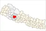 | |
| Rural Municipality | ||
| Former Rural units (VDCs) |
| |
| Wikimedia Commons has media related to Rolpa District. |