Morang District
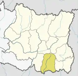
Morang District (Nepali: मोरङ जिल्ला ![]() listen ) is located in Province No. 1 in eastern Nepal. It is an Outer Terai district. It borders with Bihar, India to the South, Jhapa to the East, Dhankuta and Panchthar to the North, and Sunsari to the west. Morang has one metropolitan city (Biratnagar), eight municipalities and eight rural municipalities. The total area of Morang is 1,855 km2 (716 sq mi). The lowest elevation point is 60 meters and the highest is 2410 meters above sea level. The headquarters of Morang is connected by Koshi National Highway to the east–west Mahendra National Highway at Itahari, Sunsari, and Morang is also connected to the Hill parts of the eastern region of Nepal. Morang is the core industrial sector for the eastern region of Nepal.
listen ) is located in Province No. 1 in eastern Nepal. It is an Outer Terai district. It borders with Bihar, India to the South, Jhapa to the East, Dhankuta and Panchthar to the North, and Sunsari to the west. Morang has one metropolitan city (Biratnagar), eight municipalities and eight rural municipalities. The total area of Morang is 1,855 km2 (716 sq mi). The lowest elevation point is 60 meters and the highest is 2410 meters above sea level. The headquarters of Morang is connected by Koshi National Highway to the east–west Mahendra National Highway at Itahari, Sunsari, and Morang is also connected to the Hill parts of the eastern region of Nepal. Morang is the core industrial sector for the eastern region of Nepal.
Morang District
मोरङ जिल्ला | |
|---|---|
District | |
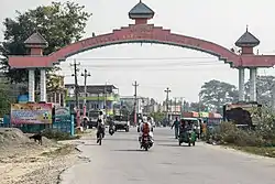 Main Entrance of Biratnagar, Morang | |
 | |
| Country | |
| Province | Province 1 |
| Established | 7th century circa |
| Admin HQ. | Biratnagar |
| Government | |
| • Type | Coordination committee |
| • Body | DCC, Morang |
| • Head | Mr. Naresh Prasad Pokhrel |
| • Deputy-Head | Mr. Prakash Kumar Shah |
| • Parliamentary constituencies | 6 |
| • Provincial constituencies | 12 |
| Area | |
| • Total | 1,855 km2 (716 sq mi) |
| Population (2011[1]) | |
| • Total | 965,370 |
| • Density | 520/km2 (1,300/sq mi) |
| Time zone | UTC+05:45 (NPT) |
| Main Language(s) | Nepali, Maithili, Tharu, Rajbanshi, Limbu |
| Website | www |
Geography and climate
| Climate Zone[2] | Elevation Range | % of Area |
|---|---|---|
| Lower Tropical | below 300 meters (1,000 ft) | 80.9% |
| Upper Tropical | 300 to 1,000 meters 1,000 to 3,300 ft. |
11.5% |
| Subtropical | 1,000 to 2,000 meters 3,300 to 6,600 ft. |
7.4% |
| Temperate | 2,000 to 3,000 meters 6,400 to 9,800 ft. |
0.2% |
Morang lies in the Outer Terai, or plains, of Eastern Nepal. Most of the land is taken up by rice and jute cultivation, though areas of sal forest remain along the northern part of the district where the plains meet the hills.
Demographics
At the time of the 2011 Nepal census, Morang District had a population of 965,370. Of these, 27.6% spoke Nepali, 33.6% Maithili, 5.9% Tharu, 3.8% Rajbanshi, 3.7% Limbu, 3.2% Urdu, 2.0% Santali, 1.9% Tamang, 1.9% Angika, 1.9% Magar, 1.5% Newari, 1.3% Bhujel, 1.1% Dhimal, 0.9% Bantawa, 0.8% Bhojpuri, 0.7% Tajpuriya, 0.6% Hindi, 0.6% Uranw/Urau, 0.6% Rajasthani, 0.5% Gurung and 0.5% Chamling as their first language.
43.9% of the population in the district spoke Nepali, 2.9% Hindi, 2.2% Maithili, 0.8% Bantawa, 0.8% Tharu and 0.6% Rajbanshi as their second language.[3]
Economy
Most of the district is rural, though it is also home to Biratnagar, the second largest city in Nepal after Kathmandu, capital city of the Country. It is the industrial capital of Nepal. Morang has the highest numbers of industries and factories, multinational brands. Other emerging towns include Urlabari, Biratchowk, Belbari, khorsane Pathari and Rangeli. It has the largest industrial area in the whole country, expanding from Rani Mills Area to Duhabi River. Biratnagar Jute Mills, Arihant and Dhanawat Matches are among the nation's oldest industries.
Education
Morang district is home to the historic Morang Campus (Mahendra Morang Adarsh Multiple Campus, Biratnagar), Sukuna Multiple Campus (Sundar Haraicha Municipality), Urlabari Multiple Campus, Pathari Multiple Campus, and several other institutions of higher learning. Sukuna Multiple Campus has around 5000 students situated at Sunderharaincha of Morang district. Purbanchal University in Biratnagar offers graduate level courses in many disciplines of Science, Arts and Liberal Sciences. At present, the University has broadly identified Industry-Technology, Agriculture-Forestry, Environment- Rural-Cultural Subsistence and Sustainable Development as specific areas of “Academic Excellence”. It has affiliated private in all the parts of Nepal.
Politics
Morang has been a hotbed of political activity throughout Nepal's recent history producing political stalwarts such as Matrika Prasad Koirala, BP Koirala, Madan Bhandari, Girija Prasad Koirala, Man Mohan Adhikari, Sushil Koirala, Bharat Mohan Adhikari as well as the present time leaders like Shekhar Koirala, Upendra Yadav, etc.
The district currently sends nine members to the national legislature.
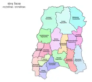
Administrative divisions
The district consists of one Metropolitan Cities, eight urban municipalities and eight rural municipalities. These are as follows:
Municipalities
References
- Household and population by districts, Central Bureau of Statistics (CBS) Nepal Archived 2013-07-31 at the Wayback Machine
- The Map of Potential Vegetation of Nepal - a forestry/agroecological/biodiversity classification system (PDF), Forest & Landscape Development and Environment Series 2-2005 and CFC-TIS Document Series No.110., 2005, ISBN 87-7903-210-9, retrieved Nov 22, 2013
- 2011 Nepal Census, Social Characteristics Tables
Further reading
- Shaha, Rishikesh (1992). Ancient and Medieval Nepal. Manohar Publications, New Delhi. ISBN 978-81-85425-69-6.
- Shreshta, S.H (2005). Nepal in Maps. Kathmandu: Educational Publishing House. p. 129.
- Shreshta, Vinod Prasad (2007). A Concise Geography of Nepal. Kathmandu: Mandal Publications. p. 126. ISBN 978-99946-55-04-5.
- Woodhatch, Tom (1999). Nepal handbook. The Royal Palace. Footprint Travel Guides. p. 194. ISBN 978-1-900949-44-6. Retrieved 2009-12-17.
External links
- "Districts of Nepal". Statoids.
| Wikimedia Commons has media related to Morang District. |