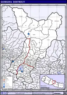
Gorkha District
Gorkha District (Nepali: गोरखा जिल्ला ![]() Listen ), a part of Gandaki Province, is one of the 77 districts of Nepal, which is the fourth largest district (by area) of Nepal and connected historically with the creation of the modern Nepal and the name of the legendary Gurkha soldiers. The district, with Gorkha Municipality (previously known as Prithivi Narayan Nagarpalika) as its district headquarters, covers an area of 3,610 km2 (1,390 sq mi) and has a population of 271,061 according to the 2011 Census of Nepal.[1] Gorkha district is the site of the Manakamana Temple.[2] The temples of Gorakh Nath and Gorakh Kali are found in the district. Several major rivers—the Chepe, Daraudi, Marsyangdi, Budi Gandaki, and Trishuli—run through the district.
Listen ), a part of Gandaki Province, is one of the 77 districts of Nepal, which is the fourth largest district (by area) of Nepal and connected historically with the creation of the modern Nepal and the name of the legendary Gurkha soldiers. The district, with Gorkha Municipality (previously known as Prithivi Narayan Nagarpalika) as its district headquarters, covers an area of 3,610 km2 (1,390 sq mi) and has a population of 271,061 according to the 2011 Census of Nepal.[1] Gorkha district is the site of the Manakamana Temple.[2] The temples of Gorakh Nath and Gorakh Kali are found in the district. Several major rivers—the Chepe, Daraudi, Marsyangdi, Budi Gandaki, and Trishuli—run through the district.
Gorkha District
गोरखा | |
|---|---|
District | |
_2.jpg.webp) Gorkha museum in Gorkha | |
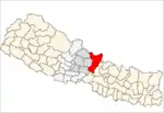
 Location of Gorkha (dark yellow) in Gandaki Province | |
| Country | Nepal |
| Province | Gandaki Province |
| Established | 12th century |
| Government | |
| • Type | Coordination committee |
| • Body | DCC, Gorkha |
| Area | |
| • Total | 3,610 km2 (1,390 sq mi) |
| Population (2011) | |
| • Total | 272,169 |
| • Density | 75/km2 (200/sq mi) |
| Time zone | UTC+05:45 (NPT) |
| Telephone Code | 064 |
| Main Language(s) | Nepali, Ghale, Gurung, Magar, Newari, Miya |
Origin
There are two legends associated with naming of "Gorkha":
- In Nepali, kharka means 'grassland'. Kharka later became garkha, then gorkha.
- Myth holds that a saint named Gorakhnath appeared for the first time in Nepal in Gorkha. There remains a cave with his paduka ('footprint') and a likeness which supports the myth. As the city was established in the place where Sage Gorakhnath appeared, it was named Gorkha.
Geography and climate
| Climate Zone[3] | Elevation Range | % of Area |
|---|---|---|
| Lower Tropical | below 300 meters (1,000 ft) | 0.1% |
| Upper Tropical | 300 to 1,000 meters 1,000 to 3,300 ft. |
19.8% |
| Subtropical | 1,000 to 2,000 meters 3,300 to 6,600 ft. |
14.6% |
| Temperate | 2,000 to 3,000 meters 6,400 to 9,800 ft. |
13.3% |
| Subalpine | 3,000 to 4,000 meters 9,800 to 13,100 ft. |
14.9% |
| Alpine | 4,000 to 5,000 meters 13,100 to 16,400 ft. |
10.6% |
| Nival | above 5,000 meters | 11.5% |
| Trans-Himalayan[4] | 3,000 to 6,400 meters 9,800 to 21,000 ft. |
14.8% |
Mountains
- Manaslu (8,163 m)
- Himalchuli (7,895 m)
- Shringi Himal (7,177 m)
- Buddha Himal (6,674 m)
- Ganesh Himal (7,422 m)
- Ngadi Chuli (7,871 m)
- Nar Phu : Peri Range 5748 m
- Ganesh VI : Ganesh Himal range (6480 m)
- Tobsar Peak : Shringi Himal range (6100m)
Transport
Gorkha town has daily bus services to and from Kathmandu (six hours) and Pokhara (three hours).[6]
Demographics
At the time of the 2011 Nepal census, Gorkha District had a population of 271,061. Of these, 72.9% spoke Nepali, 13.3% Gurung, 4.7% Magar, 3.9% Tamang, 1.1% Ghale, 2.6% Urdu, 0.7% Newari, 2.6% Miya 0.6% Kumal, 0.6% Chepang, and 0.5% Bajjika as their first language. Chhetri&Brahmin are largest indigenous group in this region. Brahmin surnames such as Pandey, Koirala, Acharya, Adhikari, Kattel, Khanal etc. and Chhetri surnames such as Khadka, Thapa, Shah, Basnet, Malla etc. are mostly found in Gorkha.
24.7% of the population in the district spoke Nepali, 0.8% Gurung and 0.5% Magar as their second language.[7]
Health care

Following is the data obtained from the PHASE Nepal website:
- Central/regional/zonal hospitals: 0
- District hospitals: 2
- Primary healthcare centres: 3
- Health posts: 10
- Sub-health post: 55
- Number of doctors: 8
A district hospital is in Gorkha, the municipal hospital in Amppipal is supported by a German NGO.
The small health centers in many village development committees (VDCs) are without Auxiliary Health Workers (AHWs), Auxiliary Nurse Midwives (ANMs) and Community Health Workers (CHWs). So, people seeking emergency health assistance have to travel a long distance to the district headquarters or Kathmandu or end up dying because of lack of treatment. Many people still believe in Dhami and Jhakri and are against taking medicine or going to the hospital for the treatment. An NGO, PHASE Nepal provides many health care facilities and training programs to three VDCs: Sirdibas, Bihi/Prok and Chumchet. Many people residing in these VDCs have benefited from the program.[8]
Educational status

As per the National Population and Housing Census of Nepal 2011, the literacy rate of Gorkha is 66.34%. The female literacy rate is 59.44% and the male literacy rate is 75.09%.
Administration
The district consists of 11 Municipalities, out of which two are urban municipalities and nine are rural municipalities. These are as follows:[9]
- Gorkha Municipality
- Palungtar Municipality
- Sulikot Rural Municipality
- Siranchowk Rural Municipality
- Ajirkot Rural Municipality
- Tsum Nubri Rural Municipality
- Dharche Rural Municipality
- Bhimsen Thapa Rural Municipality
- Sahid Lakhan Rural Municipality
- Aarughat Rural Municipality
- Gandaki Rural Municipality
Former Village Development Committees
Prior to the restructuring of the district, Gorkha District consisted of the following municipalities and Village development committees:
- Aanppipal
- Aaru Arbang
- Aaru Chanuate
- Aarupokhari
- Asrang
- Baguwa
- Bakrang
- Bhirkot
- Bhumlichok
- Bihi
- Borlang
- Barpak
- Bunkot
- Chhaikampar
- Chhoprak
- Chumchet
- Chyangli
- Darbhung
- Deurali
- Dhawa
- Dhuwakot
- Gaikhur
- Gakhu
- Ghairung
- Ghyachok
- Ghyalchok
- Gorakhkali
- Gorkha Municipality
- Gumda
- Hansapur
- Harmi
- Jaubari
- Kashigaun
- Kerabari
- Kerauja
- Kharibot
- Khoplang
- Laprak
- Lapu
- Lho
- Makaising
- Manakamana
- Manbu
- Masel
- Mirkot
- Muchhok
- Namjung
- Nareshwar
- Palungtar Municipality
- Panchkhuwadeurali
- Pandrung
- Phinam
- Phujel
- Prok
- Ranishwara
- Samagaun
- Saurpani
- Srinathkot
- Simjung
- Sirdibas
- Swara
- Taklung
- Takukot
- Takumajhalakuribot
- Tandrang
- Tanglichok
- Taple
- Tara Nagar
- Thalajung
- Thumi
- Uiya
- Barpak
References
- "National Population and Housing Census 2011(National Report)" (PDF). Central Bureau of Statistics. Government of Nepal. November 2012. Archived from the original (PDF) on 2013-04-18. Retrieved 27 January 2021.
- "Dakshinkali and Manakamana Temple tours". Mission Eco Trek. Archived from the original on 2015-05-26. Retrieved 2014-08-13.
- The Map of Potential Vegetation of Nepal - a forestry/agroecological/biodiversity classification system (PDF), Forest & Landscape Development and Environment Series 2-2005 and CFC-TIS Document Series No.110., 2005, ISBN 87-7903-210-9, retrieved Nov 22, 2013
- Shrestha, Mani R.; Rokaya, Maan B.; Ghimire, Suresh K. (2005). "Vegetation pattern of Trans-Himalayan zone in the North-West Nepal". Nepal Journal of Plant Sciences. 1: 129–135. Retrieved Feb 7, 2014.
- Banerji, Gargi; Basu, Sejuti. "Climate Change and Himalayan Cold Deserts: Mapping vulnerability and threat to ecology and indigenous livelihoods" (PDF). Pragya. Gurgaon, Haryana, India. Retrieved February 7, 2014.
- http://www.tourismkathmandu.com/things_to_do/kathmandu_and_surrounds/details/gorkha
- 2011 Nepal Census, Social Characteristics Tables
- "Project Area: Gorkha". PHASE Nepal.
- "स्थानिय तह" (in Nepali). Ministry of Federal Affairs and General Administration. Archived from the original on 31 August 2018. Retrieved 1 September 2018.
External links
 Gorkha travel guide from Wikivoyage
- "Districts of Nepal". Statoids.
| Wikimedia Commons has media related to Gorkha District. |