National Register of Historic Places listings in Loudon County, Tennessee
This is a list of the National Register of Historic Places listings in Loudon County, Tennessee.
Location of Loudon County in Tennessee
This is intended to be a complete list of the properties and districts on the National Register of Historic Places in Loudon County, Tennessee, United States. Latitude and longitude coordinates are provided for many National Register properties and districts; these locations may be seen together in a map.[1]
There are 24 properties and districts listed on the National Register in the county. Another 2 properties were once listed but have been removed.
| Anderson – Bedford – Benton – Bledsoe – Blount – Bradley – Campbell – Cannon – Carroll – Carter – Cheatham – Chester – Claiborne – Clay – Cocke – Coffee – Crockett – Cumberland – Davidson – Decatur – DeKalb – Dickson – Dyer – Fayette – Fentress – Franklin – Gibson – Giles – Grainger – Greene – Grundy – Hamblen – Hamilton – Hancock – Hardeman – Hardin – Hawkins – Haywood – Henderson – Henry – Hickman – Houston – Humphreys – Jackson – Jefferson – Johnson – Knox – Lake – Lauderdale – Lawrence – Lewis – Lincoln – Loudon – Macon – Madison – Marion – Marshall – Maury – McMinn – McNairy – Meigs – Monroe – Montgomery – Moore – Morgan – Obion – Overton – Perry – Pickett – Polk – Putnam – Rhea – Roane – Robertson – Rutherford – Scott – Sequatchie – Sevier – Shelby – Smith – Stewart – Sullivan – Sumner – Tipton – Trousdale – Unicoi – Union – Van Buren – Warren – Washington – Wayne – Weakley – White – Williamson – Wilson |
- This National Park Service list is complete through NPS recent listings posted January 29, 2021.[2]
Current listings
| [3] | Name on the Register[4] | Image | Date listed[5] | Location | City or town | Description |
|---|---|---|---|---|---|---|
| 1 | Blair's Ferry Storehouse | 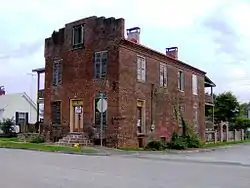 Blair's Ferry Storehouse |
July 14, 1977 (#77001277) |
800 Main St. 35°44′27″N 84°20′00″W |
Loudon | |
| 2 | Bowman House | 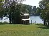 Bowman House |
July 8, 1970 (#70000610) |
East of Loudon on Little River Rd. 35°42′51″N 84°15′15″W |
Loudon | |
| 3 | Bussell Island Site |  Bussell Island Site |
March 29, 1978 (#78002606) |
On Bussell Island in the Little Tennessee River[6] 35°46′58″N 84°15′23″W |
Lenoir City | |
| 4 | Cannon-Calloway House | July 8, 1970 (#70000611) |
West of Loudon off U.S. Route 11 35°41′51″N 84°22′44″W |
Loudon | ||
| 5 | Craigs Chapel AME Zion Church | 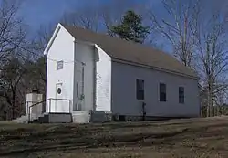 Craigs Chapel AME Zion Church |
March 12, 2001 (#01000256) |
Craigs Chapel Rd. 35°38′58″N 84°10′22″W |
Greenback | Added as part of MTSU's survey of rural African-American churches in Tennessee |
| 6 | Cumberland Presbyterian Church of Loudon | 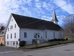 Cumberland Presbyterian Church of Loudon |
April 15, 1982 (#82003988) |
College St. 35°44′28″N 84°20′21″W |
Loudon | |
| 7 | Dunbar Public School | 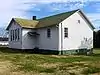 Dunbar Public School |
November 15, 2007 (#07001196) |
113 Steekee St. 35°44′14″N 84°20′12″W |
Loudon | Currently a community center |
| 8 | Fort Loudon Hydroelectric Project |  Fort Loudon Hydroelectric Project |
August 11, 2017 (#100001469) |
1280 City Park Dr. 35°47′27″N 84°14′34″W |
Lenoir City | |
| 9 | Greenback Depot | 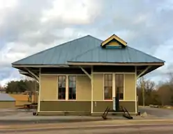 Greenback Depot |
December 18, 2013 (#13000950) |
6736 Morganton Rd. 35°39′40″N 84°10′18″W |
Greenback | Built by the L&N in 1914 |
| 10 | William H. Griffitts House | 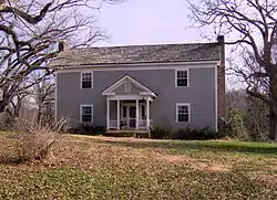 William H. Griffitts House |
March 2, 1989 (#89000141) |
Jackson Ferry-Greenback Rd. 35°40′26″N 84°13′39″W |
Greenback | |
| 11 | Hackney Chapel AME Zion Church | 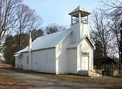 Hackney Chapel AME Zion Church |
July 10, 2000 (#00000729) |
Junction of Antioch and Hackney Chapel Rds. [7] 35°44′41″N 84°11′49″W |
Lenoir City | Added as part of MTSU's survey of rural African-American churches in Tennessee |
| 12 | Lenoir City Company | 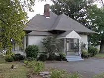 Lenoir City Company |
March 19, 1982 (#82003987) |
Depot St. 35°47′26″N 84°15′54″W |
Lenoir City | Now a museum, originally the main office of the failed Lenoir City Company, c. 1890 |
| 13 | Lenoir Cotton Mill Warehouse | 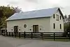 Lenoir Cotton Mill Warehouse |
July 6, 2006 (#06000584) |
150 Bussells Ferry Rd. 35°47′13″N 84°15′25″W |
Lenoir City | Now a residence, originally a warehouse used by the Lenoir Cotton Mill |
| 14 | Albert Lenoir House | 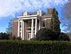 Albert Lenoir House |
April 11, 1973 (#73001808) |
West of Loudon on River Rd. (State Route 72) 35°44′20″N 84°22′21″W |
Loudon | Located where River Rd. crosses Sweetwater Creek |
| 15 | Loudon County Courthouse | 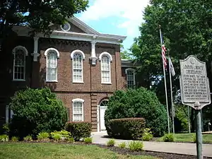 Loudon County Courthouse |
May 28, 1975 (#75001768) |
Grove and Mulberry Sts. 35°44′28″N 84°20′10″W |
Loudon | |
| 16 | Mason Place | 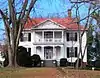 Mason Place |
November 27, 1989 (#89002029) |
600 Commerce St. 35°45′01″N 84°20′32″W |
Loudon | |
| 17 | McCollum Farm | 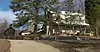 McCollum Farm |
April 15, 1978 (#78002605) |
Southwest of Greenback on Morganton Rd. 35°39′00″N 84°12′13″W |
Greenback | |
| 18 | Melton Hill Hydroelectric Project | 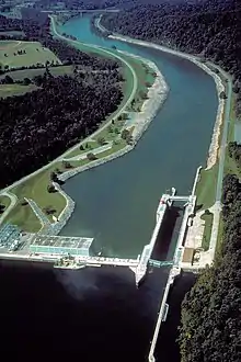 Melton Hill Hydroelectric Project |
August 11, 2017 (#100001470) |
2009 Grubb Rd. 35°53′07″N 84°18′00″W |
Lenoir City | |
| 19 | National Campground | 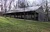 National Campground |
January 7, 1972 (#72001243) |
State Route 1 35°41′15″N 84°13′24″W |
Greenback | |
| 20 | Robinson Mill | 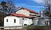 Robinson Mill |
April 5, 1984 (#84003592) |
State Route 72 35°43′24″N 84°19′21″W |
Loudon | |
| 21 | Tellico Dam Project | 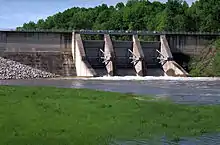 Tellico Dam Project |
August 14, 2017 (#100001471) |
c/o 1280 City Park Dr. 35°46′40″N 84°15′35″W |
Lenoir City | |
| 22 | War Memorial Building | 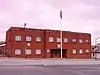 War Memorial Building |
December 29, 2011 (#11000979) |
103 N. B St. 35°47′28″N 84°16′02″W |
Lenoir City | Constructed as a memorial for local veterans in 1951 |
| 23 | Orme Wilson and Company Storehouse | 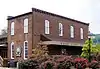 Orme Wilson and Company Storehouse |
February 12, 1980 (#80003845) |
Hackberry St. 35°44′31″N 84°20′05″W |
Loudon | Now home to the Wharf Street Coffeehouse; located adjacent to the formerly-listed Carmichael Inn |
| 24 | John Winton House | 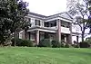 John Winton House |
July 17, 2003 (#03000665) |
18350 Martel Rd. 35°49′28″N 84°12′53″W |
Lenoir City |
Former listings
| [3] | Name on the Register | Image | Date listed | Date removed | Location | City or town | Summary |
|---|---|---|---|---|---|---|---|
| 1 | Carmichael Inn | 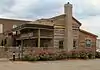 Carmichael Inn |
July 8, 1970 (#87000999) | November 25, 1987 | Off US 11 |
Loudon | Relocated into greater Loudon. |
| 2 | Lenoir Cotton Mill | 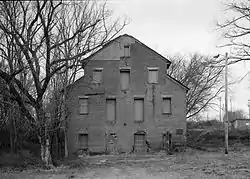 Lenoir Cotton Mill |
June 18, 1975 (#75001767) | July 30, 2002 | Depot Street |
Lenoir City | Destroyed by arsonist in 1991. |
See also
| Wikimedia Commons has media related to National Register of Historic Places in Loudon County, Tennessee. |
References
- The latitude and longitude information provided in this table was derived originally from the National Register Information System, which has been found to be fairly accurate for about 99% of listings. Some locations in this table may have been corrected to current GPS standards.
- "National Register of Historic Places: Weekly List Actions". National Park Service, United States Department of the Interior. Retrieved on January 29, 2021.
- Numbers represent an alphabetical ordering by significant words. Various colorings, defined here, differentiate National Historic Landmarks and historic districts from other NRHP buildings, structures, sites or objects.
- "National Register Information System". National Register of Historic Places. National Park Service. April 24, 2008.
- The eight-digit number below each date is the number assigned to each location in the National Register Information System database, which can be viewed by clicking the number.
- Location derived from the GNIS feature record for Bussell Island; the NRIS lists the site as "Address Restricted"
- Location derived from the Google map available via the "Satellite Photo" link at this Hackney Chapel webpage (archive.org version); NRIS lists the site as "Address Restricted".
| Topics | |
|---|---|
| Lists by state |
|
| Lists by insular areas | |
| Lists by associated state | |
| Other areas | |
| Related | |
| |
Municipalities and communities of Loudon County, Tennessee, United States | ||
|---|---|---|
| Cities | ||
| Towns | ||
| CDP | ||
| Unincorporated communities | ||
| Footnotes | ‡This populated place also has portions in an adjacent county or counties | |
| ||
This article is issued from Wikipedia. The text is licensed under Creative Commons - Attribution - Sharealike. Additional terms may apply for the media files.