Bettencourt-Rivière
Bettencourt-Rivière is a commune in the Somme department in Hauts-de-France in northern France.
Bettencourt-Rivière | |
|---|---|
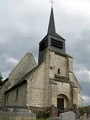 The church in Bettencourt-Rivière | |
 Coat of arms | |
Location of Bettencourt-Rivière 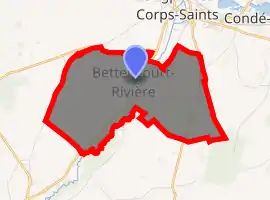
| |
 Bettencourt-Rivière  Bettencourt-Rivière | |
| Coordinates: 49°59′52″N 1°58′41″E | |
| Country | France |
| Region | Hauts-de-France |
| Department | Somme |
| Arrondissement | Abbeville |
| Canton | Gamaches |
| Intercommunality | CA Baie de Somme |
| Government | |
| • Mayor (2001–2008) | René Drouvin |
| Area 1 | 7.38 km2 (2.85 sq mi) |
| Population | 230 |
| • Density | 31/km2 (81/sq mi) |
| Time zone | UTC+01:00 (CET) |
| • Summer (DST) | UTC+02:00 (CEST) |
| INSEE/Postal code | 80099 /80270 |
| Elevation | 11–94 m (36–308 ft) (avg. 20 m or 66 ft) |
| 1 French Land Register data, which excludes lakes, ponds, glaciers > 1 km2 (0.386 sq mi or 247 acres) and river estuaries. | |
Geography
The commune is situated on the D216 road, some 15 miles (24 km) southeast of Abbeville. The commune is made up of two villages: Bettencourt to the west, on the left bank of the small river Airaines and Rivière to the east, on the right bank of the river.
Population
| Year | 1962 | 1968 | 1975 | 1982 | 1990 | 1999 | 2006 |
|---|---|---|---|---|---|---|---|
| Population | 166 | 183 | 168 | 161 | 200 | 212 | 226 |
| From the year 1962 on: No double counting—residents of multiple communes (e.g. students and military personnel) are counted only once. | |||||||
Places of interest
- Bettencourt church
- Rivière church
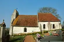
Rivière church
See also
References
- "Populations légales 2017". INSEE. Retrieved 6 January 2020.
| Wikimedia Commons has media related to Bettencourt-Rivière. |
| Authority control |
|---|
This article is issued from Wikipedia. The text is licensed under Creative Commons - Attribution - Sharealike. Additional terms may apply for the media files.