Dominois
Dominois is a commune in the Somme department in Hauts-de-France in northern France.
Dominois | |
|---|---|
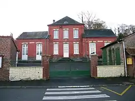 The town hall in Dominois | |
.svg.png.webp) Coat of arms | |
Location of Dominois 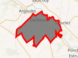
| |
 Dominois  Dominois | |
| Coordinates: 50°19′56″N 1°51′12″E | |
| Country | France |
| Region | Hauts-de-France |
| Department | Somme |
| Arrondissement | Abbeville |
| Canton | Rue |
| Intercommunality | CC Ponthieu-Marquenterre |
| Government | |
| • Mayor (2020–2026) | Jean-Louis Labry |
| Area 1 | 6.15 km2 (2.37 sq mi) |
| Population (2017-01-01)[1] | 177 |
| • Density | 29/km2 (75/sq mi) |
| Time zone | UTC+01:00 (CET) |
| • Summer (DST) | UTC+02:00 (CEST) |
| INSEE/Postal code | 80244 /80120 |
| Elevation | 7–74 m (23–243 ft) (avg. 13 m or 43 ft) |
| 1 French Land Register data, which excludes lakes, ponds, glaciers > 1 km2 (0.386 sq mi or 247 acres) and river estuaries. | |
Geography
Dominois is situated on the D192 road, on the banks of the river Authie, the département border with the Pas-de-Calais, some 20 miles (32 km) north of Abbeville.
Population
| Year | 1962 | 1968 | 1975 | 1982 | 1990 | 1999 | 2006 |
|---|---|---|---|---|---|---|---|
| Population | 176 | 209 | 201 | 183 | 169 | 141 | 146 |
| From the year 1962 on: No double counting—residents of multiple communes (e.g. students and military personnel) are counted only once. | |||||||
See also
References
- "Populations légales 2017". INSEE. Retrieved 6 January 2020.
| Wikimedia Commons has media related to Dominois. |
| Authority control |
|---|
This article is issued from Wikipedia. The text is licensed under Creative Commons - Attribution - Sharealike. Additional terms may apply for the media files.