Bouzincourt
Bouzincourt is a commune in the Somme department in Hauts-de-France in northern France.
Bouzincourt | |
|---|---|
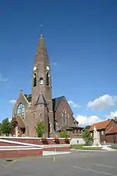 The church in Bouzincourt | |
Location of Bouzincourt 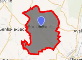
| |
 Bouzincourt  Bouzincourt | |
| Coordinates: 50°01′38″N 2°36′45″E | |
| Country | France |
| Region | Hauts-de-France |
| Department | Somme |
| Arrondissement | Péronne |
| Canton | Albert |
| Intercommunality | Pays du Coquelicot |
| Government | |
| • Mayor (2001–2008) | Michel Thorelle |
| Area 1 | 8.11 km2 (3.13 sq mi) |
| Population | 550 |
| • Density | 68/km2 (180/sq mi) |
| Time zone | UTC+01:00 (CET) |
| • Summer (DST) | UTC+02:00 (CEST) |
| INSEE/Postal code | 80129 /80300 |
| Elevation | 67–134 m (220–440 ft) (avg. 106 m or 348 ft) |
| 1 French Land Register data, which excludes lakes, ponds, glaciers > 1 km2 (0.386 sq mi or 247 acres) and river estuaries. | |
The name Bouzincourt is derived from the words for forest (bosquet) and the typical Picardy village suffix '-court' . It was therefore a wooded village.
Geography
Bouzincourt is situated on the junction of the D938 and D20 roads, some 18 miles (29 km) northeast of Amiens.
Places of interest
- The church of St. Honore was destroyed during World War I but reconstructed in 1920 in the shape of a bullet. The tower is 36m high.
- The stained-glass windows were restored by l'École de Nancy, and are worthy of attention.
- The ‘muches’, man-made tunnels where the population hid during times of war.
Population
| Year | 1962 | 1968 | 1975 | 1982 | 1990 | 1999 | 2006 |
|---|---|---|---|---|---|---|---|
| Population | 543 | 564 | 537 | 580 | 535 | 511 | 519 |
| From the year 1962 on: No double counting—residents of multiple communes (e.g. students and military personnel) are counted only once. | |||||||
See also
References
- "Populations légales 2017". INSEE. Retrieved 6 January 2020.
External links
| Wikimedia Commons has media related to Bouzincourt. |
(All French language)
| Authority control |
|---|
This article is issued from Wikipedia. The text is licensed under Creative Commons - Attribution - Sharealike. Additional terms may apply for the media files.
