Roisel
Roisel is a commune in the Somme department in Hauts-de-France in northern France.
Roisel | |
|---|---|
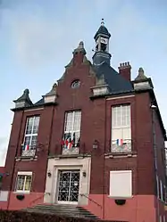
 The town hall in Roisel | |
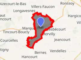
Location of Roisel 
| |
 Roisel  Roisel | |
| Coordinates: 49°56′47″N 3°05′55″E | |
| Country | France |
| Region | Hauts-de-France |
| Department | Somme |
| Arrondissement | Péronne |
| Canton | Péronne |
| Intercommunality | Haute Somme |
| Government | |
| • Mayor (2001–2008) | Michel Boulogne |
| Area 1 | 10.16 km2 (3.92 sq mi) |
| Population (2017-01-01)[1] | 1,613 |
| • Density | 160/km2 (410/sq mi) |
| Time zone | UTC+01:00 (CET) |
| • Summer (DST) | UTC+02:00 (CEST) |
| INSEE/Postal code | 80677 /80240 |
| Elevation | 67–142 m (220–466 ft) (avg. 75 m or 246 ft) |
| 1 French Land Register data, which excludes lakes, ponds, glaciers > 1 km2 (0.386 sq mi or 247 acres) and river estuaries. | |
Geography
Roisel is situated 10 miles (16 km) northwest of Saint Quentin, on the D6 road, with the small river ‘La Cologne’ (a tributary of the Somme River) flowing through the commune.
Population
| Year | Pop. | ±% p.a. |
|---|---|---|
| 1968 | 1,908 | — |
| 1975 | 1,846 | −0.47% |
| 1982 | 1,976 | +0.98% |
| 1990 | 1,960 | −0.10% |
| 1999 | 1,929 | −0.18% |
| 2007 | 1,821 | −0.72% |
| 2012 | 1,740 | −0.91% |
| 2017 | 1,613 | −1.50% |
| Source: INSEE[2] | ||
History
The name of Roisel has an etymology close to that of "roseau" (en:reed) and it's possible, given the ponds, lakes and marches, that the commune takes its name from the landscape. Roisel has strong connections with Saint Fursey.
Places of interest
- St Martin's church. Destroyed during World War I, it was rebuilt by local architect Louis Faille, from Nurlu, soon after 1928
- The town hall (Hotel de ville), rebuilt in 1926 by Maurice Lucet].
See also
References
- "Populations légales 2017". INSEE. Retrieved 6 January 2020.
- Population en historique depuis 1968, INSEE
| Wikimedia Commons has media related to Roisel. |
This article is issued from Wikipedia. The text is licensed under Creative Commons - Attribution - Sharealike. Additional terms may apply for the media files.
