Senarpont
Senarpont is a commune in the Somme department and Hauts-de-France region of northern France.
Senarpont | |
|---|---|
 The Place du General Leclerc | |
.svg.png.webp) Coat of arms | |
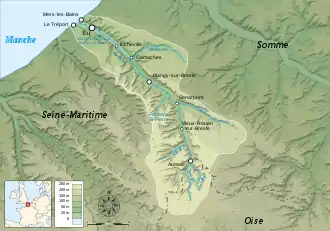
Location of Senarpont 
| |
 Senarpont  Senarpont | |
| Coordinates: 49°53′24″N 1°43′07″E | |
| Country | France |
| Region | Hauts-de-France |
| Department | Somme |
| Arrondissement | Amiens |
| Canton | Poix-de-Picardie |
| Intercommunality | CC Somme Sud-Ouest |
| Government | |
| • Mayor (2014–2020) | Béatrice Delhomelle |
| Area 1 | 7 km2 (3 sq mi) |
| Population (2017-01-01)[1] | 647 |
| • Density | 92/km2 (240/sq mi) |
| Time zone | UTC+01:00 (CET) |
| • Summer (DST) | UTC+02:00 (CEST) |
| INSEE/Postal code | 80732 /80140 |
| Elevation | 61–177 m (200–581 ft) (avg. 80 m or 260 ft) |
| 1 French Land Register data, which excludes lakes, ponds, glaciers > 1 km2 (0.386 sq mi or 247 acres) and river estuaries. | |
Geography
Senarpont is situated at the confluence of the rivers Liger and Bresle some 42 km west of Amiens, on the D1015 road.
Senarpont at the confluence of the rivers Liger and Bresle
Population
| Year | Pop. | ±% p.a. |
|---|---|---|
| 1968 | 625 | — |
| 1975 | 727 | +2.18% |
| 1982 | 769 | +0.81% |
| 1990 | 800 | +0.50% |
| 1999 | 770 | −0.42% |
| 2007 | 707 | −1.06% |
| 2012 | 678 | −0.83% |
| 2017 | 647 | −0.93% |
| Source: INSEE[2] | ||
See also
References
- "Populations légales 2017". INSEE. Retrieved 6 January 2020.
- Population en historique depuis 1968, INSEE
| Wikimedia Commons has media related to Senarpont. |
This article is issued from Wikipedia. The text is licensed under Creative Commons - Attribution - Sharealike. Additional terms may apply for the media files.
