Molliens-Dreuil
Molliens-Dreuil is a commune in the Somme department in Hauts-de-France in northern France.
Molliens-Dreuil | |
|---|---|
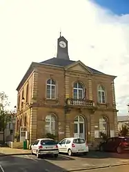 The town hall in Molliens-Dreuil | |
 Coat of arms | |
Location of Molliens-Dreuil 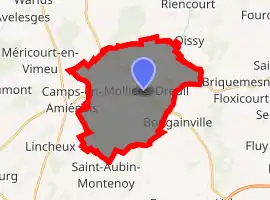
| |
 Molliens-Dreuil  Molliens-Dreuil | |
| Coordinates: 49°53′02″N 2°01′12″E | |
| Country | France |
| Region | Hauts-de-France |
| Department | Somme |
| Arrondissement | Amiens |
| Canton | Ailly-sur-Somme |
| Intercommunality | CC Somme Sud-Ouest |
| Government | |
| • Mayor (2001–2008) | Victor Delezenne |
| Area 1 | 22.8 km2 (8.8 sq mi) |
| Population (2017-01-01)[1] | 958 |
| • Density | 42/km2 (110/sq mi) |
| Time zone | UTC+01:00 (CET) |
| • Summer (DST) | UTC+02:00 (CEST) |
| INSEE/Postal code | 80554 /80540 |
| Elevation | 40–129 m (131–423 ft) (avg. 49 m or 161 ft) |
| 1 French Land Register data, which excludes lakes, ponds, glaciers > 1 km2 (0.386 sq mi or 247 acres) and river estuaries. | |
Geography
The commune is situated on the D211 and D69 roads, some 13 miles (21 km) west of Amiens, in the valley of a small stream called the St.Landon.
History
By a decree of 19 September 1972, the two communes of Dreuil-lès-Molliens and Molliens-Vidame were combined into one, Molliens-Dreuil.
Molliens was first a commune in 1209 and was under the jurisdiction of the seigneurs of Picquigny from the twelfth century right up until the French Revolution, as was the neighbouring village of Dreuil.
Population
| Year | Pop. | ±% p.a. |
|---|---|---|
| 1968 | 555 | — |
| 1975 | 582 | +0.68% |
| 1982 | 789 | +4.44% |
| 1990 | 878 | +1.34% |
| 1999 | 830 | −0.62% |
| 2007 | 888 | +0.85% |
| 2012 | 810 | −1.82% |
| 2017 | 958 | +3.41% |
| Source: INSEE[2] | ||
Places of interest
- Evidence of a feudal motte.
- sixteenth century church of St.Pierre-aux-Liens
- eighteenth century church of Saint Martin. Displayed inside is a 15th-century bas-relief of Christ.

Dreuil-lès-Molliens school and Mayor's office
_1.jpg.webp)
Dusk at the Mayor's office
See also
References
- "Populations légales 2017". INSEE. Retrieved 6 January 2020.
- Population en historique depuis 1968, INSEE
This article is issued from Wikipedia. The text is licensed under Creative Commons - Attribution - Sharealike. Additional terms may apply for the media files.