Hédauville
Hédauville is a commune in the Somme department in Hauts-de-France in northern France.
Hédauville | |
|---|---|
.JPG.webp) The town hall in Hédauville | |
Location of Hédauville 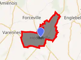
| |
 Hédauville  Hédauville | |
| Coordinates: 50°02′46″N 2°34′07″E | |
| Country | France |
| Region | Hauts-de-France |
| Department | Somme |
| Arrondissement | Péronne |
| Canton | Albert |
| Intercommunality | Pays du Coquelicot |
| Government | |
| • Mayor (2001–2008) | Patrice Basserie |
| Area 1 | 4.04 km2 (1.56 sq mi) |
| Population (2017-01-01)[1] | 126 |
| • Density | 31/km2 (81/sq mi) |
| Time zone | UTC+01:00 (CET) |
| • Summer (DST) | UTC+02:00 (CEST) |
| INSEE/Postal code | 80425 /80560 |
| Elevation | 83–142 m (272–466 ft) (avg. 99 m or 325 ft) |
| 1 French Land Register data, which excludes lakes, ponds, glaciers > 1 km2 (0.386 sq mi or 247 acres) and river estuaries. | |
Geography
Hédauville is situated on the D938 and D919 crossroads, some 20 miles (32 km) northeast of Amiens.
History
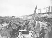
British 6 inch Mk VII gun in action behind a chalk ridge near Hédauville, west of the Ancre, 4.5 miles NW of Albert, France. It is firing in V Corps sector against the first phase of the German Kaiserschlacht offensive, Operation Michael, 26 March 1918.
Population
| Year | 1962 | 1968 | 1975 | 1982 | 1990 | 1999 | 2006 |
|---|---|---|---|---|---|---|---|
| Population | 116 | 123 | 97 | 98 | 89 | 100 | 108 |
| From the year 1962 on: No double counting—residents of multiple communes (e.g. students and military personnel) are counted only once. | |||||||
See also
References
- "Populations légales 2017". INSEE. Retrieved 6 January 2020.
| Wikimedia Commons has media related to Hédauville. |
| Authority control |
|---|
This article is issued from Wikipedia. The text is licensed under Creative Commons - Attribution - Sharealike. Additional terms may apply for the media files.