Flers, Somme
Flers is a commune near the northern edge of the Somme department in Hauts-de-France in northern France.
Flers | |
|---|---|
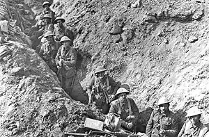 Trenches near Flers, in September 1916 | |
Location of Flers 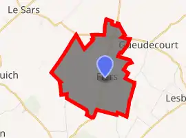
| |
 Flers  Flers | |
| Coordinates: 50°02′57″N 2°49′20″E | |
| Country | France |
| Region | Hauts-de-France |
| Department | Somme |
| Arrondissement | Péronne |
| Canton | Péronne |
| Intercommunality | Haute Somme |
| Government | |
| • Mayor (2001–2008) | Jeannette Busschaert |
| Area 1 | 6.27 km2 (2.42 sq mi) |
| Population (2017-01-01)[1] | 195 |
| • Density | 31/km2 (81/sq mi) |
| Time zone | UTC+01:00 (CET) |
| • Summer (DST) | UTC+02:00 (CEST) |
| INSEE/Postal code | 80314 /80360 |
| Elevation | 108–151 m (354–495 ft) (avg. 127 m or 417 ft) |
| 1 French Land Register data, which excludes lakes, ponds, glaciers > 1 km2 (0.386 sq mi or 247 acres) and river estuaries. | |
It lies to the south of the D929 road, between Albert and Bapaume.
History
In 1916, the Battle of Flers–Courcelette saw the first use of the tank (the Mark I) in the field of battle.
Demography
| Year | 1962 | 1968 | 1975 | 1982 | 1990 | 1999 | 2006 |
|---|---|---|---|---|---|---|---|
| Population | 210 | 220 | 212 | 184 | 182 | 138 | 159 |
| From the year 1962 on: No double counting—residents of multiple communes (e.g. students and military personnel) are counted only once. | |||||||
See also
References
- "Populations légales 2017". INSEE. Retrieved 6 January 2020.
| Wikimedia Commons has media related to Flers, Somme. |
| Authority control |
|---|
This article is issued from Wikipedia. The text is licensed under Creative Commons - Attribution - Sharealike. Additional terms may apply for the media files.
