Namps-Maisnil
Namps-Maisnil is a commune in the Somme department in Hauts-de-France in northern France.
Namps-Maisnil | |
|---|---|
_1.jpg.webp) The church in Taisnil | |
Location of Namps-Maisnil 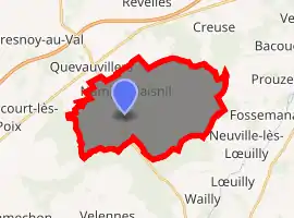
| |
 Namps-Maisnil  Namps-Maisnil | |
| Coordinates: 49°48′13″N 2°06′28″E | |
| Country | France |
| Region | Hauts-de-France |
| Department | Somme |
| Arrondissement | Amiens |
| Canton | Ailly-sur-Noye |
| Intercommunality | CC Somme Sud-Ouest |
| Government | |
| • Mayor (2001–2008) | Michel Delamare |
| Area 1 | 21.96 km2 (8.48 sq mi) |
| Population (2017-01-01)[1] | 987 |
| • Density | 45/km2 (120/sq mi) |
| Time zone | UTC+01:00 (CET) |
| • Summer (DST) | UTC+02:00 (CEST) |
| INSEE/Postal code | 80582 /80290 |
| Elevation | 55–149 m (180–489 ft) (avg. 87 m or 285 ft) |
| 1 French Land Register data, which excludes lakes, ponds, glaciers > 1 km2 (0.386 sq mi or 247 acres) and river estuaries. | |
Geography
A commune created by the amalgamation, in 1972, of the four old communes of Namps-au-Mont, Namps-au-Val, Rumaisnil and Taisnil. The commune is surrounded by forests and situated at the junction of the D169, D61 and D38 roads, some 9 miles (14 km) southwest of Amiens.
Population
| Year | Pop. | ±% p.a. |
|---|---|---|
| 1968 | 818 | — |
| 1975 | 836 | +0.31% |
| 1982 | 890 | +0.90% |
| 1990 | 970 | +1.08% |
| 1999 | 1,002 | +0.36% |
| 2007 | 1,032 | +0.37% |
| 2012 | 996 | −0.71% |
| 2017 | 987 | −0.18% |
| Source: INSEE[2] | ||
Places of interest
- The war memorial at Taisnil
- The church at Namps-au-Val
- The Château of Namps-au-Mont
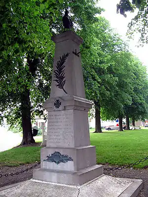
Taisnil war memorial
See also
References
- "Populations légales 2017". INSEE. Retrieved 6 January 2020.
- Population en historique depuis 1968, INSEE
| Wikimedia Commons has media related to Namps-Maisnil. |
| Authority control |
|
|---|
This article is issued from Wikipedia. The text is licensed under Creative Commons - Attribution - Sharealike. Additional terms may apply for the media files.