Cerisy-Buleux
Cerisy-Buleux is a commune in the Somme department in Hauts-de-France in northern France.
Cerisy-Buleux | |
|---|---|
%252C_France_(2).JPG.webp) The church in Cerisy-Buleux | |
Location of Cerisy-Buleux 
| |
 Cerisy-Buleux  Cerisy-Buleux | |
| Coordinates: 49°58′33″N 1°44′23″E | |
| Country | France |
| Region | Hauts-de-France |
| Department | Somme |
| Arrondissement | Amiens |
| Canton | Poix-de-Picardie |
| Intercommunality | CC Somme Sud-Ouest |
| Government | |
| • Mayor (2014–2020) | Dominique Bayart |
| Area 1 | 5.6 km2 (2.2 sq mi) |
| Population (2017-01-01)[1] | 266 |
| • Density | 48/km2 (120/sq mi) |
| Time zone | UTC+01:00 (CET) |
| • Summer (DST) | UTC+02:00 (CEST) |
| INSEE/Postal code | 80183 /80140 |
| Elevation | 96–127 m (315–417 ft) (avg. 103 m or 338 ft) |
| 1 French Land Register data, which excludes lakes, ponds, glaciers > 1 km2 (0.386 sq mi or 247 acres) and river estuaries. | |
Geography
The commune is situated on the D190 road, some 15 miles (24 km) southwest of Abbeville.
Population
| Year | 1962 | 1968 | 1975 | 1982 | 1990 | 1999 | 2006 | 2011 | 2014 |
|---|---|---|---|---|---|---|---|---|---|
| Population | 336 | 342 | 281 | 272 | 278 | 260 | 255 | 258 | 263 |
| From the year 1962 on: No double counting—residents of multiple communes (e.g. students and military personnel) are counted only once. | |||||||||
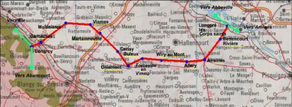
Places of interest
- The old railway line:[2]
The railway, opened in 1872, was closed on 10 November 1993. Mostly freight trains for the many farming cooperatives, there were also a few passenger trains.
References
- "Populations légales 2017". INSEE. Retrieved 6 January 2020.
- Source:Fcvnet
External links
| Wikimedia Commons has media related to Cerisy-Buleux. |
- The old railway (in French)
| Authority control |
|---|
This article is issued from Wikipedia. The text is licensed under Creative Commons - Attribution - Sharealike. Additional terms may apply for the media files.