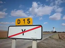
Y, Somme
Y (pronounced [i]) is a commune in the Somme department in Hauts-de-France in northern France.
Y | |
|---|---|
 | |
 Coat of arms | |
Location of Y 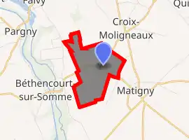
| |
 Y  Y | |
| Coordinates: 49°48′14″N 2°59′34″E | |
| Country | France |
| Region | Hauts-de-France |
| Department | Somme |
| Arrondissement | Péronne |
| Canton | Ham |
| Intercommunality | Est de la Somme |
| Government | |
| • Mayor (2020-2026) | Vinncent Joly |
| Area 1 | 2.73 km2 (1.05 sq mi) |
| Population (2017-01-01)[1] | 92 |
| • Density | 34/km2 (87/sq mi) |
| Demonym(s) | Ypsilonien(ne) |
| Time zone | UTC+01:00 (CET) |
| • Summer (DST) | UTC+02:00 (CEST) |
| INSEE/Postal code | 80829 /80190 |
| Elevation | 56–82 m (184–269 ft) (avg. 72 m or 236 ft) |
| 1 French Land Register data, which excludes lakes, ponds, glaciers > 1 km2 (0.386 sq mi or 247 acres) and river estuaries. | |
_church_(flickruser1banaan).jpg.webp)
Y bears the shortest place name in France, and one of the shortest in the world.[2] The inhabitants call themselves Ypsilonien(ne)s,[3][4] from the Greek letter Upsilon (Υ), which looks like the letter Y.
Geography
Y is situated 50 kilometres (30 miles) east of Amiens, at the junction of the D15 and D615 roads, in the far eastern side of the department. The mayor is Vinncent Jolly.[5]
History
The district belonged to the Y family from Vermandois.[6]
The village was caught up in the First World War. It was decorated by Croix de guerre 1914-1918 on 15 December 1920.[7] The Church of Saint-Médard17, was rebuilt in 1921, after the destruction caused by the First World War.[8]
Since 2002, the commune has been part of the community of communes of the Pays Hamois, which succeeded the district of Ham, created in 1960. Then on 1 Jan 2017, Pays Hamois and that of the Pays Neslois, merged.
Population
At the French Revolution the commune had 160 inhabitants; as of 2017 its legal population was 92 habitants.
|
| ||||||||||||||||||||||||||||||||||||||||||||||||||||||||||||||||||||||||||||||||||||||||||||||||||||||||||||||||||
| Source: EHESS[9] and INSEE (1968-2017)[10] | |||||||||||||||||||||||||||||||||||||||||||||||||||||||||||||||||||||||||||||||||||||||||||||||||||||||||||||||||||
See also
References
- "Populations légales 2017". INSEE. Retrieved 6 January 2020.
- Ash, Russell (10 November 2011). Boring, Botty and Spong. RHCP. p. 70. ISBN 978-1-4090-9739-6.
- "Promouvoir le village d'Y" (in French). Annuaire Mairie.
- "Dictionary gives labels for locals `From Abilene to Zimbabwe'". Deseret Times. Associated Press. 12 September 1997.
- 1
- Notice historique et géographique, réalisée par l'instituteur, M. Huguet, 1899, Archives départementales, Amiens
- Journal officiel du 16 décembre 1920, p. 20825.
- Oswald Macqueron, « Aquarelle : Église d'Y, d'après nature, 18 octobre 1876. » [archive], Documents numérisés, fonds Macqueron, Bibliothèque municipale d'Abbeville.
- Données Cassini, EHESS
- Population en historique depuis 1968, INSEE
External links
| Wikimedia Commons has media related to Y (Somme). |
- Y on the Quid website (in French)
| Authority control |
|---|
