Durhama
Durhama is a small village in Baramulla district in the Indian union territory of Jammu and Kashmir. It is about 20 km from District headquarters Baramulla, 13 km from the Apple town Sopore and 50 km from Batmaloo, Srinagar via Putukhah- Wagoora road and 44 Km via Tapper-Kreeri road . It is about 100m away from the Tehsil headquarter Wagoora and about 3.5 km from the medical block Kreeri. It is situated on the left side of the link road which connects Baramulla and Babareshi-Gulmarg. The village has three mosques and 85 households. The population of Durhama is about 650. There is a primary and a middle school in the outskirts of the village. The literacy rate of Durhama is about 67% below than the state level which is about 68.5%. A building of The Block Development Office Wagoora is located at the entrance of Durhama. A medical sub centre is also located alongside B.D.O. office.
Durhama | |
|---|---|
Village | |
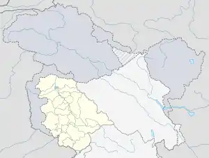
 Durhama Location in Jammu and Kashmir, India  Durhama Durhama (India) | |
| Coordinates: 33.62°N 74.87°E | |
| Country | |
| Union territory | Jammu and Kashmir |
| District | Baramulla |
| Languages | |
| • Spoken | Kashmiri, Urdu |
| Time zone | UTC+5:30 (IST) |
| PIN | 193109 |
People of Durhama are very brave, hard-working and courageous. People here mostly depend on agriculture and horticulture sector for their living.70% of population directly or indirectly depend on it. A handful of people are working in government sector and some are running their own private business. 5% of population is living under Below Poverty Line. The village is surrounded by small hills or karewas with orchard trees laden on them. This adds to the beauty of the village.