Bijbehara
Bijbehara is a town and a notified area committee in Anantnag district of the Indian administered union territory of Jammu and Kashmir. It is located on National Highway NH-1 A (Old highway), connecting the Kashmir Valley with the rest of India. Bijbehara town is also known as "Chinar Town" because of two Chinar gardens (Paadshaahi Bagh and Darashukoh Garden) which are known for their chinars trees. Bijbehara is the home to oldest chinar tree in the region. The town is situated about 45 km (28 mi) from the summer capital of union territory of Jammu and Kashmir, Srinagar.
Bijbehara
Vejibyour | |
|---|---|
Town | |
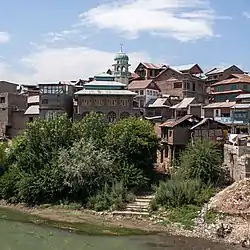 View of central Bijbehara | |
 Bijbehara Location in Jammu and Kashmir, India  Bijbehara Bijbehara (India) | |
| Coordinates: 33.80°N 75.10°E | |
| Country | |
| Union territory | Jammu and Kashmir |
| District | Anantnag |
| Elevation | 1,591 m (5,220 ft) |
| Population (2011) | |
| • Total | 22,789 Excluding - Takia Bal And Ghad Hanjipora |
| Languages | |
| • Official | Urdu Kashmiri |
| Time zone | UTC+5:30 (IST) |
| Vehicle registration | JK03 |
Etymology
The word Bijbehara or Vijbor or Vijbror has been derived from Sanskrit word Vijayeshwar. It was an ancient site of Shiva Vijayeshwar.[1]
Geography
Bijbehara is located at 33.80°N 75.10°E.[2] It has an average elevation of 1,591 metres (5,223 feet).
One of the notable towns of the district, Bijbehara is situated to the north of district headquarters on the banks of Jhelum River popularly known locally as "Veth". Bijbehara lies four miles north of Anantnag town.
The town is surrounded and intersected by plateaus, including the Totak Shah, from where the whole town can be seen. There are many other plateaus which are being urbanized.
Sangam Eidgah is a place about 8 km from main city center Lalchock. The most famous product of this place is lotus stems called naduru in the Kashmiri language. It had been said that once Baba Naseebudin Qazi RH rested for few days in this place and there is a shrine with astan at that place where he rested. Education wise Sangam has tremendously developed since 2005. There are almost 8 schools in this area including one high school and 4 middle schools.
The town localities of Bijbehara include: Goriwan chowk, Old town, Ziyarat road, Baba Mohalla, Zirpara chowk, Sadar Bazar, Vaid Mohalla, Dobighat, Khar Mohalla, Eidgah, Pandit Hamaam, Pomposh Mohalla, Saraf Mohalla, Peershah Mohalla, Ahanger Mohalla, Feroze Shah Mohalla, Sheikh Mohalla, and GH pora.
The town has recently expanded to include new housing colonies such as: New Colony Bijbehara, Eidgah basti, Qazi Mohalla, Sicop Colony, Padshahi Bagh Colony, Friends Colony, Deewan Bagh, Eidgah Colony, and Tehsil Road-Baghandar.
The important villages on the outskirts of town include: Pazalpora, Jablipora, Arwani, Subhaanpora, Sangam, Dupatyar, Katriteng, Gundinowroze and Semthan.
Demographics
The town had a population of 22,789 (12,057 men and 10,732 women) per the report released by Census India 2011.[3] Children aged 0–6 made up 14.97% (3,411) of the total population of Bijbehara.
Religious places
- Baba Naseeb-ud-Din Ghazi shrine, Bijbehara
- Totak shah Sahib shrine, Hill Station New colony Bijbehara
List of villages in Bijbehara Tehsil
There are about 52 villages in Bijbehara:
- Ader
- Arwani
- Aswara
- Bander Pora
- Bewora
- Batagund
- Chini Gund
- Chunda Pora
- Dari Gund
- Dupt Yar
- Gadhanji Pora
- Gantali Pora
- Gadiseer Bijbehara
- Gori
- Gund Chel
- Gund Nasir
- Gund Nowroze
- Hamzeh Pora
- Hati Gam
- Haussan Pora Bagh
- Hayar
- Inder Mooni
- Jabli Pora
- Joibal
- Kanalwan
- Kandi Pora
- Katu
- Khiram
- Khush Roi Kalan
- Kitriteng
- Krandi Gam
- Laribal
- Mahind
- Marhama
- Meera Gund
- Niyana Gund Baba Khalil
- Nowshehra
- Opzan
- Rakh Hassain Pora
- Rakh Moman Dangit Pora
- Rakhi Kitri Teng
- Sangam
- Semthan
- Shala Gam
- Shiti Pora
- Sir Hama
- Sither Satghar
- Sotki Pora
- Subhan Pahari
- Takia Bal
- Thaji War
- Trubji
- Tula Khan
- Vedai
- Veeri
- Waghama
Education
- Gov. Degree College Bijbehara
- Public School English Medium Bijbehara
- Delhi Public School ,Sangam ,Bijbehara
- Gov. Boys Model Hr. Sec. School
- Gov. Girls Model Hr. Sec. School
- Oxford Public School
- Crescent Public School
- Gems Public School
- Cambridge Public School
- Kashmir Public School
- Zenith Institute Of Education
- Zaiba Aapa Inst. Of Inclusive Edu.
- Kashmir Public School
- Big Bang School Sicop
- Sky Touch School
Notable people
- Mufti Mohammad Sayeed was a politician from the state of Jammu and Kashmir. He served as Chief Minister of Jammu and Kashmir and Home Minister of India.
- Mehbooba Mufti is the president of the Jammu & Kashmir Peoples Democratic Party. She is the daughter of Mufti Mohammad Sayeed.
- Parvez Rasool, an Indian cricketer.
Divisions
The areas which come under the constituency of Bijbehara are as follows:
- Mattan
- Nanil
- Kanelwon
- Khiram
- Akura
References
- Cultural Heritage of Jammu and Kashmir, p.161
- "Maps, Weather, and Airports for Bijbiara, India". Retrieved 19 September 2016.
- "Bijbehara City Population Census 2011 - Jammu and Kashmir". www.census2011.co.in. Retrieved 8 June 2016.
External links
| Passes |  | |
|---|---|---|
| Valleys | ||
| Cities | ||
| Towns |
| |
| Rivers | ||
| Glaciers | ||
| Lakes | ||
| Mountains | ||
| Hill stations and Mughal gardens | ||
| Protected Areas | ||
| See also | ||