Yusmarg
Yusmarg or Yousmarg (meaning 'Meadow of Jesus') is a hill station in the western part of Kashmir Valley in the Indian union territory of Jammu and Kashmir. It is situated 47 km south of Srinagar the capital of the state. Yousmarg provides space for beautiful landscapes, young pine nurseries, green pastures and heart touching lotic and lentic water bodies. Neilnag, Doudganga and a nascently created artificial dam adds more to the beauty of the meadows.Nature has bestowed Yoususmarg with pleasant flora and fauna. Among fauna, locals claim that they often sight wolves, bears, apes, cats, aves of various types (flight as well as flightless). Among aquatic fauna, Schizothoraxic is abundant one in catch.
Yousmarg
The Meadow of Jesus[1] | |
|---|---|
Hill station | |
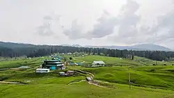 View of Yusmarg | |
 Yousmarg Location in Jammu and Kashmir, India  Yousmarg Yousmarg (India) | |
| Coordinates: 33.83°N 75.30°E | |
| Country | |
| Union territory | Jammu and Kashmir |
| District | Budgam |
| Elevation | 2,396 m (7,861 ft) |
| Languages | |
| • Official | Urdu |
| Time zone | UTC+5:30 (IST) |
| Vehicle registration | JK |
Geography
Yusmarg in Kashmiri means The Meadow of Jesus.[2] It is believed by the Ahmadiyya Muslim Community that Jesus came to Kashmir and stayed at Yusmarg for some time.[3] It is an alpine valley covered with snow clad mountains and the meadows of Pine and Fir. It lies 13 km (8.1 mi) south of Charari Sharief, a town in Budgam district of Jammu and Kashmir. It is situated at the bank of Doodganga River which is a tributary of Jehlum River. It is located in the Pir Panjal peaks, a sub range of Himalaya. The Peaks are: the Sunset Peak and the Tatakooti Peak for which the expeditions lead from this hill station. It lies at an altitude of 2,396 m (7,861 ft) above sea level.[4]
Tourism
A trek of 4 km leads to a small lake. Another 10 km trek leads to the frozen lake in Sang-e-Safed valley, which is mostly covered by ice even during the summer. Other tourist activities include horse riding, fishing, skiing during winter and photography.[5]
Access
Yusmarg is easily accessed from Srinagar or Srinagar Airport (SXR),[6] the capital of Jammu and Kashmir, 47 km. The drive in under 2 hours by car or bus leads through Charari Sharief town.[7] During winter the road sometimes gets closed due to snowfall and remains cut off from the Kashmir Valley for weeks.
References
- "Meaning of Yusmarg". visitmanalikulu.com. Retrieved 21 June 2012.
- Parvéz Dewân (2004). Parvéz Dewân's Jammû, Kashmîr, and Ladâkh: Kashmîr. Manas Publications, 2004. p. 195–. ISBN 9788170491798. Retrieved 30 June 2012.
- B.K. Chaturvedi (1983). Tourist Centers Of India. Diamond Pocket Books (P) Ltd. p. 81–. ISBN 9788171821372. Retrieved 21 June 2012.
- M.S. Kohli (1983). The Himalayas: Play Ground of the Gods Trekking Climbling Adventure. Indus Publishing, 1983. p. 40–. ISBN 9788173871078. Retrieved 21 June 2012.
- "Yusmarg a hill station". yda.co.in. Archived from the original on 29 October 2011. Retrieved 21 June 2012.
- "Reaching Yusmarg". nativeplanet.com. Retrieved 1 July 2012.
- "How to reach Yusmarg". kashmirtourism.com. Retrieved 1 July 2012.
External links
| External video | |
|---|---|
| Passes |  | |
|---|---|---|
| Valleys | ||
| Cities | ||
| Towns |
| |
| Rivers | ||
| Glaciers | ||
| Lakes | ||
| Mountains | ||
| Hill stations and Mughal gardens | ||
| Protected Areas | ||
| See also | ||