National Register of Historic Places listings in Charles Mix County, South Dakota
This is a list of the National Register of Historic Places listings in Charles Mix County, South Dakota.
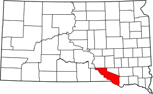
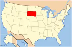
Location of Charles Mix County in South Dakota
This is intended to be a complete list of the properties and districts on the National Register of Historic Places in Charles Mix County, South Dakota, United States. The locations of National Register properties and districts for which the latitude and longitude coordinates are included below, may be seen in a map.[1]
There are 15 properties and districts listed on the National Register in the county. Another property was once listed but has been removed.
- This National Park Service list is complete through NPS recent listings posted January 29, 2021.[2]
Current listings
| [3] | Name on the Register[4] | Image | Date listed[5] | Location | City or town | Description |
|---|---|---|---|---|---|---|
| 1 | Charles Mix County Courthouse | 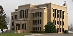 Charles Mix County Courthouse |
February 10, 1993 (#92001856) |
Main St. between 4th and 5th Sts. 43°09′20″N 98°32′16″W |
Lake Andes | |
| 2 | Church of Christ in LaRoche Township | 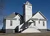 Church of Christ in LaRoche Township |
July 1, 1982 (#82003920) |
Highway 50 43°27′20″N 99°04′57″W |
Academy | |
| 3 | Engel Hotel | _from_NE_2.JPG.webp) Engel Hotel |
February 21, 2012 (#12000035) |
202 Main St. 43°09′22″N 98°32′34″W |
Lake Andes | |
| 4 | Farmers State Bank of Platte | _from_E_1.JPG.webp) Farmers State Bank of Platte |
January 27, 1983 (#83003004) |
404 S. Main St.[6] 43°23′13″N 98°50′42″W |
Platte | |
| 5 | Geddes Historic District | 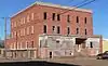 Geddes Historic District |
May 8, 1973 (#73001737) |
Off Highway 50 43°15′15″N 98°41′43″W |
Geddes | |
| 6 | Henry Cool Park | 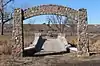 Henry Cool Park |
March 15, 2011 (#11000083) |
0.5 miles (0.80 km) north of the intersection of Highway 50 and 365th Ave 43°23′16″N 98°53′35″W |
Platte | |
| 7 | Holy Fellowship Episcopal Church | June 5, 1975 (#75001712) |
Southeast of Greenwood 42°55′23″N 98°23′10″W |
Greenwood | ||
| 8 | Jacobson School | _from_SE_1.JPG.webp) Jacobson School |
February 5, 2003 (#02001762) |
289th St. 43°11′55″N 98°19′38″W |
Armour | |
| 9 | Lake Andes Carnegie Library | 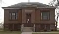 Lake Andes Carnegie Library |
June 2, 2000 (#00000598) |
500 Main St. 43°09′21″N 98°32′18″W |
Lake Andes | |
| 10 | Marty Mission School Gymnasium and St. Therese Hall | Marty Mission School Gymnasium and St. Therese Hall |
January 4, 2012 (#11001012) |
Southwest corner of 303rd St. & 388th Ave. 42°59′33″N 98°25′32″W |
Marty | part of Schools in South Dakota MPS |
| 11 | Pickstown Fire and Police Station | March 26, 2020 (#100005109) |
108 Lewis Ave. 43°04′07″N 98°31′55″W |
Pickstown | ||
| 12 | Pratt & Gjolme Building |  Pratt & Gjolme Building |
June 8, 2007 (#07000532) |
500 S. Main 43°23′10″N 98°50′42″W |
Platte | Listed in the NRHP as "Pratt & Cjolme"[7] |
| 13 | Rising Hail Colony | 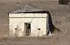 Rising Hail Colony |
April 28, 1975 (#75001713) |
5 miles (8.0 km) northwest of Greenwood along Seven Mile Creek 43°00′13″N 98°28′58″W |
Greenwood | |
| 14 | Security State Bank of Dante | November 1, 2018 (#100003072) |
320 Main St. 43°02′18″N 98°11′05″W |
Dante | ||
| 15 | Wagner House | 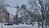 Wagner House |
November 19, 2007 (#07001209) |
29649 401st. Ave. 43°05′31″N 98°10′31″W |
Wagner |
Former listing
| [3] | Name on the Register | Image | Date listed | Date removed | Location | City or town | Summary |
|---|---|---|---|---|---|---|---|
| 1 | South Dakota Dept. of Transportation Bridge No. 12-503-230 | December 9, 1993 (#93001278) | December 15, 1999 | Local road over Choteau Creek |
Wagner |
See also
| Wikimedia Commons has media related to National Register of Historic Places in Charles Mix County, South Dakota. |
References
- The latitude and longitude information provided in this table was derived originally from the National Register Information System, which has been found to be fairly accurate for about 99% of listings. Some locations in this table may have been corrected to current GPS standards.
- "National Register of Historic Places: Weekly List Actions". National Park Service, United States Department of the Interior. Retrieved on January 29, 2021.
- Numbers represent an alphabetical ordering by significant words. Various colorings, defined here, differentiate National Historic Landmarks and historic districts from other NRHP buildings, structures, sites or objects.
- "National Register Information System". National Register of Historic Places. National Park Service. April 24, 2008.
- The eight-digit number below each date is the number assigned to each location in the National Register Information System database, which can be viewed by clicking the number.
- See "StarBanks Coffee & Wine", "Restaurants/Lounges", Platte, South Dakota website. Retrieved 2016-02-28.
- Listed as "Pratt & Cjolme" in NRHP, and appears thus in NRHP nominating form; but see photo of building's crest. The nominating form calls the eponymous builder "H. K. Cjolme"; this is probably Hans K. Gjolme, a photo of whose tombstone appears at Find A Grave. Several contemporary sources, e.g. Twenty-Seventh Annual Report of the Board of Railroad Commissioners of the State of South Dakota for the Fiscal Year Ended June 30, 1916, p. 42, make reference to a "H. K. Gjolme" of Platte.
| Topics | |
|---|---|
| Lists by state |
|
| Lists by insular areas | |
| Lists by associated state | |
| Other areas | |
| Related | |
| |
Municipalities and communities of Charles Mix County, South Dakota, United States | ||
|---|---|---|
| Cities | | |
| Towns | ||
| CDP | ||
| Unincorporated communities | ||
| Indian reservation | ||
| ||
This article is issued from Wikipedia. The text is licensed under Creative Commons - Attribution - Sharealike. Additional terms may apply for the media files.