Beaverton, Oregon
Beaverton is a city in Washington County, in the U.S. state of Oregon that is located 7 miles (11 km) west of Portland in the Tualatin Valley. The city is among the main cities that make up the Portland metropolitan area. Its population was 89,803 at the 2010 census, making it the second-largest city in the county and the sixth-largest city in Oregon.[9] Beaverton is an economic center for Washington County along with neighboring Hillsboro. It is home to the world headquarters of Nike, Inc., which sits outside of city limits in unincorporated county land.
Beaverton, Oregon | |
|---|---|
City | |
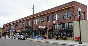 _(washD0040).jpg.webp) 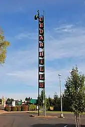 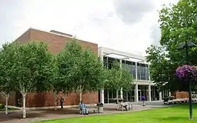 From top: Edward Earl Fisher Building in the Beaverton Downtown Historic District, Sisters of St. Mary of Oregon, Cedar Hills neon sign, Beaverton City Library | |
Flag  Seal | |
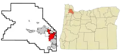 Location in Oregon | |
 Beaverton, Oregon Location in Oregon  Beaverton, Oregon Beaverton, Oregon (the United States)  Beaverton, Oregon Beaverton, Oregon (North America) | |
| Coordinates: 45°29′13″N 122°48′13″W | |
| Country | United States |
| State | Oregon |
| County | Washington |
| Incorporated | 1893 |
| Government | |
| • Mayor | Denny Doyle (D)[1] |
| • City Council[2] | |
| Area | |
| • Total | 19.58 sq mi (50.72 km2) |
| • Land | 19.58 sq mi (50.72 km2) |
| • Water | 0.00 sq mi (0.00 km2) 0% |
| Elevation | 189 ft (58 m) |
| Population | |
| • Total | 89,803 |
| • Estimate (2019)[8] | 99,037 |
| • Density | 5,057.55/sq mi (1,952.77/km2) |
| Time zone | UTC−8 (Pacific (PST)) |
| • Summer (DST) | UTC−7 (PDT) |
| ZIP codes | 97003, 97005-97008, 97075-97078 |
| Area code(s) | 503 and 971 |
| FIPS code | 41-05350[9] |
| GNIS feature ID | 1637830[10] |
| Website | City of Beaverton |
The hunter–gatherer Atfalati tribe of the Kalapuya people inhabited the Tualatin Valley prior to the arrival of European–American settlers in the 19th century. They occupied a village near the Beaverton and Fanno creeks called Chakeipi, which meant "place of the beaver", and early white settlers referred to this village as Beaverdam. Lawrence Hall took up the first land claim in 1847 and established a grist mill. The entry of a railroad in 1868 spurred growth in the small farming communities and led to the town's incorporation in 1893.
History
Early settlement
According to Oregon Geographic Names, Beaverton's name is derived from the settlement's proximity to a large body of water resulting from beaver dams.
The area of Tualatin Valley that became Beaverton was originally the home of a Native American tribe known as the Atfalati, which settlers mispronounced as Tualatin. The Atfalati population dwindled in the latter part of the 18th century, and the prosperous tribe was no longer dominant in the area by the 19th century when settlers arrived. The tribe named their village Chakeipi, which translates to "place of the beaver".[11]
The natives had a village called Chakeipi, meaning Place of the Beaver, and early settlers referred to it as "Beaverdam". Early settlers include the Hall Family from Kentucky, the Denneys who lived on their claim near present-day Scholls Ferry Road and Hall Blvd, and Orin S. Allen, from western New York.[11] Lawrence Hall purchased 640 acres (2.6 km2) in Beaverdam in 1847 and built a grist mill with his brother near present-day Walker Road.[11] His was the first land claim in the area. He was soon followed by Thomas Denney in 1848, who came to the area and built its first sawmill. In 1860, a toll plank road from Portland to Beaverton was completed over a trail called Canyon Road.[11]
After the American Civil War, numerous other settlers, including Joshua Welch, George Betts, Charles Angel, W. P. Watson, and John Henry, laid out what is now known as Beaverton hoping they could bring a railroad to an area once described as, "mostly swamps & marshes connected by beaver dams to create what looked like a huge lake." In 1872, Beaverton's first post office opened in a general store operated by Betts, who also served as the first postmaster of the community. Betts Street, where the current post office now stands, is named in honor of him. In 1893, Beaverton, which by that time had a population of 400, was officially incorporated. Alonzo Cady, a local businessman, served as the first mayor. Many major roads in Beaverton are named for these early settlers.
20th century
Beaverton was an early home to automobile dealerships. A Ford Motor Company dealership was established there in 1915; it was purchased by Guy Carr in 1923 and over the years Carr expanded it into several locations throughout Beaverton. There are still several dealerships near the intersection of Walker and Canyon Roads.
_(10).jpg.webp)
In the early 1920s, Beaverton was home to Premium Picture Productions, a movie studio which produced about fifteen films. The studio site was later converted into Watt's Field and associated aircraft manufacturing facilities. A second Beaverton airport, Bernard's Airport, was later developed farther north, at the present location of the Cedar Hills Crossing mall.
The town's first library opened in 1925. Originally on the second floor of the Cady building, it has moved repeatedly; in 2000 it was moved to its current location on Hall Boulevard and 5th Street. A branch location was opened for the first time in June 2010, when the Murray-Scholls location opened near the Murrayhill neighborhood. The Beaverton libraries and 15 other local libraries participate in the Washington County Cooperative Library Services.
_(247).jpg.webp)
21st century
In December 2004, the city and Washington County announced an "interim plan" which would lead to Beaverton becoming the second-largest city in Oregon, second only to Portland.[12] The "interim" plan actually covered a period of more than ten years; from the county's perspective,[12] the plan supported its strategy of having cities and special districts provide urban services. The city of Beaverton also attempted to annex certain businesses, including Nike, which responded with a legal and lobbying effort to resist the annexation.[13] The lobbying effort succeeded quickly, with the Oregon Legislative Assembly enacting Senate Bill 887,[14] which prohibited Beaverton from annexing Nike without the company's consent. The bill also applied to property owned by Electro Scientific Industries, Columbia Sportswear, and Tektronix, and in August 2008 the Oregon Land Use Board of Appeals ruled that the bill also barred the city from annexing property belonging to Leupold & Stevens. (See below, under Economy.) Beaverton's legal efforts to annex Nike cost the city over one million dollars.[15] In 2016, Nike unveiled plans to expand its campus by 3.2 million square feet (approximately 3 million square meters) at a projected cost of one billion dollars.[16]
The Oregon State Legislature has also passed legislation which redetermined Washington County's urban growth boundary to include more development.[17][18] In 2018, the Metro Council voted to once again expand the urban growth boundary to include the Cooper Mountain urban reserve area.[19]
In 2016, voters approved a $35 million bond for a new 75,000 square foot Public Safety Center built to withstand a major earthquake. It will house the city's Emergency Management and Police Departments.[20] Construction began in September 2018 and it is expected to open during the summer of 2020.[21][22]
The city has tried to encourage transit-oriented development around the city's MAX Light Rail stations. The Round, a mixed-use development around Beaverton Central MAX Station on the site of a former sewer plant, was announced in 1996.[23] In 2014, the City of Beaverton moved its city hall into The Beaverton Building, an office building in The Round.[24] The Round currently consists of 24,000 square foot of retail space with 63 residential condominiums located above.[25] BG's Food Cartel, Beaverton's first food cart pod, opened in 2018 and has 31 food carts, a speakeasy bar, and an event venue.[26][27] A planned arts center at the former site of the Westgate Theater, The Patricia Reser Center for the Arts, was made possible by pledges from the Beaverton Arts Foundation and Pat Reser along with public sources. The groundbreaking was performed on November 13, 2019.[28]
Geography
As of January 2020, Beaverton covers a total area of 19.7 square miles (51 km2), all of it land except for small creeks, ponds, and lakes.[29] The city is located along the eastern edge of the Tualatin Valley just west of the Tualatin Mountains. It is bordered by Portland to the east, Hillsboro to the west, and Tigard to the south. Much of the remaining area surrounding Beaverton in the north and southwest constitutes unincorporated Washington County land.[30] The elevation within city limits rises as high as 698.2 feet (212.8 m) above sea level to as low as 131.7 feet (40.1 m) above sea level. The city averages at 189 feet (58 m) above sea level.[31]
Climate
| Climate data for Beaverton, Oregon | |||||||||||||
|---|---|---|---|---|---|---|---|---|---|---|---|---|---|
| Month | Jan | Feb | Mar | Apr | May | Jun | Jul | Aug | Sep | Oct | Nov | Dec | Year |
| Record high °F (°C) | 66 (19) |
73 (23) |
79 (26) |
94 (34) |
101 (38) |
103 (39) |
106 (41) |
105 (41) |
100 (38) |
91 (33) |
72 (22) |
64 (18) |
106 (41) |
| Average high °F (°C) | 44 (7) |
52 (11) |
57 (14) |
61 (16) |
67 (19) |
75 (24) |
80 (27) |
80 (27) |
76 (24) |
64 (18) |
51 (11) |
43 (6) |
63 (17) |
| Average low °F (°C) | 31 (−1) |
35 (2) |
38 (3) |
40 (4) |
44 (7) |
51 (11) |
55 (13) |
56 (13) |
49 (9) |
42 (6) |
38 (3) |
30 (−1) |
42 (6) |
| Record low °F (°C) | 0 (−18) |
8 (−13) |
14 (−10) |
26 (−3) |
31 (−1) |
33 (1) |
41 (5) |
36 (2) |
31 (−1) |
22 (−6) |
9 (−13) |
−8 (−22) |
−8 (−22) |
| Average precipitation inches (mm) | 5.82 (148) |
4.84 (123) |
4.06 (103) |
2.79 (71) |
2.25 (57) |
1.62 (41) |
0.68 (17) |
0.84 (21) |
1.64 (42) |
2.92 (74) |
6.07 (154) |
6.41 (163) |
39.95 (1,015) |
| Source: [32] | |||||||||||||
Demographics
| Historical population | |||
|---|---|---|---|
| Census | Pop. | %± | |
| 1900 | 249 | — | |
| 1910 | 386 | 55.0% | |
| 1920 | 580 | 50.3% | |
| 1930 | 1,138 | 96.2% | |
| 1940 | 1,052 | −7.6% | |
| 1950 | 2,512 | 138.8% | |
| 1960 | 5,937 | 136.3% | |
| 1970 | 18,577 | 212.9% | |
| 1980 | 31,962 | 72.1% | |
| 1990 | 53,310 | 66.8% | |
| 2000 | 79,277 | 48.7% | |
| 2010 | 89,803 | 13.3% | |
| 2019 (est.) | 99,037 | [8] | 10.3% |
| U.S. Decennial Census[33] 2018 Estimate[34] | |||
As of 2020 the median income for a household in the city was $38,261, and the median income for a family was $71,806.[35] Males had a median income of $41,683 versus $31,204 for females. The per capita income for the city was $25,419. About 5.0% of families and 7.8% of the population were below the poverty line, including 8.5% of those under age 18 and 6.8% of those age 65 or over.
2010 census
As of the census[7] of 2010, there were 89,803 people, 37,213 households, and 21,915 families residing in the city. The population density was 4,794.6 inhabitants per square mile (1,851.2/km2). There were 39,500 housing units at an average density of 2,108.9 per square mile (814.3/km2). The racial makeup of the city was 73.0% White, 2.6% African American, 0.6% Native American, 10.5% Asian, 0.5% Pacific Islander, 8.2% from other races, and 4.5% from two or more races. Hispanic or Latino of any race were 16.3% of the population.
There were 37,213 households, of which 31.0% had children under the age of 18 living with them, 43.7% were married couples living together, 10.6% had a female householder with no husband present, 4.6% had a male householder with no wife present, and 41.1% were non-families. 30.9% of all households were made up of individuals, and 8.5% had someone living alone who was 65 years of age or older. The average household size was 2.39 and the average family size was 3.03.
The median age in the city was 34.7 years. 22.9% of residents were under the age of 18; 9.2% were between the ages of 18 and 24; 33% were from 25 to 44; 24.5% were from 45 to 64; and 10.4% were 65 years of age or older. The gender makeup of the city was 48.6% male and 51.4% female.
Economy
Company headquarters
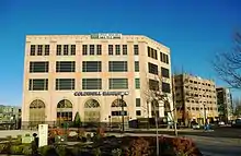
Reser's Fine Foods, processor and distributor of fresh prepared foods, has headquartered in Beaverton since 1960. Leupold & Stevens, maker of rifle scopes and other specialty optics, has been located on property adjacent to the City of Beaverton since 1968. The Beaverton City Council annexed that property in May 2005, and Leupold & Stevens challenged that annexation. The company eventually won the legal fight in 2009 with the city, thus the company was de-annexed from the city.[36] Beaverton is home to the world headquarters of Nike, Inc. Its headquarters are located on an unincorporated area inside, but excluded from, Beaverton city limits. Cedar Hills Crossing is a shopping mall within the city of Beaverton.[37]
Phoenix Technologies operates its Northwestern Regional Office in Beaverton.[38]
Technology
As part of the Silicon Forest, Beaverton is the location of numerous technology organizations and companies including[39] Linux Technology Center of IBM,[40] Tektronix, Maxim Integrated Products, VeriWave, and Oregon Technology Business Center (OTBC), a non-profit tech startup incubator.[41]
Largest employers
According to the City's 2019 Comprehensive Annual Financial Report,[42] the largest employers in the city are:
| # | Employer | # of Employees |
|---|---|---|
| 1 | Beaverton School District | 4,406 |
| 2 | Nike | 3,544 |
| 3 | Providence Health Systems | 2,028 |
| 4 | Comcast Cable | 926 |
| 5 | City of Beaverton | 649 |
| 6 | Seterus | 575 |
| 7 | IBM Corporation | 562 |
| 8 | Nationstar Mortgage | 500 |
| 9 | Fred Meyer | 478 |
| 10 | Pacific Office Automation | 402 |
Tourist attractions
- Beaverton Farmer's Market
- BG's Food Cartel
- Cooper Mountain Nature Park
- Cooper Mountain Vineyards
- Hyland Forest Park
- Red Tail Golf Center
- Tualatin Hills Nature Park
- Veterans Memorial Park (Beaverton, Oregon)
Sports
The Howard M. Terpenning Recreation Complex, opened in 1978, features swimming, athletics, tennis, baseball, softball and basketball facilities.
Little League
In 2014, the Beaverton–Aloha Little League Intermediate baseball team won the state tournament and traveled to Nogales, Arizona to play in the regional tournament, where they accumulated a 2–2 record.[43][44]
In 2006, the Murrayhill Little League baseball team qualified for the 2006 Little League World Series, the first Oregon team in 48 years to go that far. Murrayhill advanced to the semi-finals before losing; the third-place game was rained out and not rescheduled. In addition, a Junior Softball team from Beaverton went to 2006 World Series in Kirkland, Washington, ending in sixth place.
In 2002, Beaverton's Little League Softball team took second place to Waco, Texas, in the Little League Softball World Series.
Curling
In January 2013, Beaverton became the first city in Oregon to have an ice rink dedicated to the sport of curling, the Evergreen Curling Club.[45][46] In January 2017, the Evergreen Curling Club hosted the United States Curling Association Senior Women's National Championship.[47]
Education
The public schools of Beaverton are part of the Beaverton School District. There are six public high schools in the district – Aloha High School, Beaverton High School, Mountainside High School, Southridge High School, Sunset High School, and Westview High School. Private schools in the area include German American School, Holy Trinity School, Jesuit High School, Saint Cecilia Grade School, Southwest Christian School, Valley Catholic School, and WoodHaven School.
Colleges and universities
- Portland Community College (PCC — Although it is based in Portland, some facilities operate in Beaverton.)
Infrastructure
Fire protection is provided through Tualatin Valley Fire and Rescue. EMS services are provided by Metro West Ambulance.[48]
Transportation
Beaverton is served by transit bus, commuter rail, and light rail services predominantly operated by the Portland area's regional transit agency, TriMet. The agency's MAX Light Rail serves the city with seven light rail stations. From west to east, the stations are: Elmonica/Southwest 170th Avenue, Merlo Road/Southwest 158th Avenue, Beaverton Creek, Millikan Way, Beaverton Central, Beaverton Transit Center, and Sunset Transit Center.[49][50] Beaverton Transit Center is TriMet's busiest transit center;[51] it is a stop on the MAX Blue Line, which runs west to Hillsboro and east to Gresham, and the western terminus of the MAX Red Line, which runs to Portland International Airport.[52] The transit center also serves as a transfer point for numerous bus routes serving the west side and is the only MAX-served station with a connection to TriMet's WES Commuter Rail,[53] which runs south to Wilsonville. Hall/Nimbus, the second station southbound on WES, is also located in Beaverton.[54] Intercity bus services operating in Beaverton include POINT and TCTD.
Oregon Electric and Red Electric interurban lines once served the city in the early 20th century. In the 1940s, Tualatin Valley Stages, a division of Portland Stages, Inc., provided limited bus transit service connecting the city with downtown Portland,[55] operating later as a separate company, Tualatin Valley Buses, Inc., through the 1960s. This was one of four privately owned bus companies serving the Portland metropolitan area which became collectively known as the "Blue Bus" lines. All four companies were replaced in 1970 by TriMet, a then-new regional transit authority,[56] which expanded bus service to cover more areas of Beaverton.
The city is the location of a major freeway interchange for U.S. Route 26 (US 26; Sunset Highway) and Oregon Route 217 (OR 217). The Sunset Highway connects Beaverton to Hillsboro and the Oregon Coast to the west and Portland to the east. OR 217 travels from Beaverton south through Tigard and terminates at an interchange with Interstate 5 (I-5).
Notable people
- James Allsup – far-right political commentator
- Charles E. Bernard – aviator
- John Brotherton – actor
- Mike Byrne – drummer for The Smashing Pumpkins
- Janet Chvatal – actress
- Grace Crunican – general manager for Bay Area Rapid Transit
- Brad Fitzpatrick – programmer
- Ted Geoghegan – screenwriter
- Barrie Gilbert – inventor
- Ian Karmel – stand-up comedian and writer
- Gloria Calderon Kellett – writer
- Anne Kenney – television producer
- Morten Lauridsen – composer
- Michael McQuilken – director
- Moultrie Patten, jazz musician
- Aaron Rodgers – football quarterback
- Rubio Rubin – professional soccer player
- Ari Shapiro – radio journalist
- Royal Skousen – professor
- Courtney Taylor-Taylor – lead singer of The Dandy Warhols
- James B. Thayer – United States Army brigadier general
- Tommy Thayer – lead guitarist for Kiss
Sister cities
Since 1987, Beaverton has established sister city relationships with six foreign cities:[57]
| City | Division | Nation | Year of Partnership |
|---|---|---|---|
| Gotenba | 1987 | ||
| Hsinchu | Taiwan Province | 1988 | |
| Cheonan | South Chungcheong Province | 1989 | |
| Birobidzhan | 1990 | ||
| Trossingen | 1993 | ||
| Cluses | 1999 |
References
- "Denny Doyle". Democratic Party of Oregon. Retrieved October 2, 2015.
- "Councilor: Position 1 | Beaverton, OR – Official Website". beavertonoregon.gov. Retrieved May 29, 2019.
- "Lacey Beaty | Democratic Party of Oregon". dpo.org. Retrieved May 29, 2019.
- Schmidt, Brad (May 1, 2010). "Eight candidates seek three seats on Beaverton City Council". The Oregonian. Retrieved May 29, 2019.
- "Democratic Party of Oregon". dpo.org. Retrieved May 29, 2019.
- "2019 U.S. Gazetteer Files". United States Census Bureau. Retrieved July 28, 2020.
- "U.S. Census website". United States Census Bureau. Retrieved December 21, 2012.
- "Population and Housing Unit Estimates". United States Census Bureau. May 24, 2020. Retrieved May 27, 2020.
- "American Factfinder". 2010 Census. United States Census Bureau. Retrieved August 4, 2012.
- "US Board on Geographic Names". United States Geological Survey. October 25, 2007. Retrieved January 31, 2008.
- "Beaverton History". City of Beaverton. Archived from the original on September 28, 2007. Retrieved September 7, 2007.
- County Board Approves Interim Plan with Beaverton Archived August 18, 2006, at the Wayback Machine, a December 2004 article from the Washington County website
- Statement By Nike Regarding The Recent Annexation Actions By The City Of Beaverton Archived November 14, 2006, at the Wayback Machine
- Oregon State Bill 887 as enrolled Archived March 3, 2006, at the Wayback Machine from the Oregon Legislative Assembly website
- "Beaverton hopes repaired relationship with Nike will help city's future". The Oregonian. April 13, 2013. Retrieved May 22, 2020.
- "Nike unveils design for world headquarters expansion in Oregon". KATU. January 20, 2016. Retrieved May 8, 2020.
- http://www.co.washington.or.us/LUT/PlanningProjects/reserves/whats-new.cfm
- http://www.co.washington.or.us/LUT/PlanningProjects/Bethany/upload/North-Bethany-Study-Areas-Map.pdf
- "Urban Growth Boundary Expansion". Beaverton, Oregon website. Retrieved May 19, 2020.
- Wong, Peter. "Beaverton clears way to complete Public Safety Center". joomlakave.com. Retrieved May 19, 2020.
- "Public Safety Center | Beaverton, OR – Official Website". beavertonoregon.gov. Archived from the original on July 12, 2017. Retrieved May 19, 2020.
- "Public Safety Center | Beaverton Police Department, OR". beavertonpolice.org. Retrieved May 19, 2020.
- Schmidt, Brad (August 14, 2010). "The Round's tenacious tenants survive their winter of discontent". The Oregonian. Retrieved June 10, 2015.
- Vidyasagar, Aparna (August 7, 2014). "City of Beaverton Departments To Move Into 'The Round'". OPB. Archived from the original on June 12, 2015. Retrieved June 10, 2015.
- "About the Round". The Round. Retrieved May 1, 2020.
- "BG Food Cartel | Beaverton's Largest Food Cart Pod". BG Food Cartel. Retrieved May 1, 2020.
- "Beaverton's first super food cart pod opens". KGW. Retrieved May 1, 2020.
- "Patricia Reser Center for the Arts". prca.beavertonoregon.gov. Retrieved May 1, 2020.
- Beaverton, Oregon City Map (Map). City of Beaverton, Oregon. January 2020. Retrieved April 19, 2020.
- Beaverton & Vicinity (Map). City of Beaverton, Oregon. January 2020. Retrieved April 19, 2020.
- "Community Profile". City of Beaverton, Oregon. Retrieved April 19, 2020.
- "Average Weather for Beaverton, OR – Temperature and Precipitation". Weather.com. Retrieved January 21, 2011.
- United States Census Bureau. "Census of Population and Housing". Retrieved September 25, 2013.
- "Population Estimates". United States Census Bureau. Retrieved June 8, 2018.
- "U.S. Census Bureau QuickFacts: Beaverton city, Oregon; Portland city, Oregon; Eugene city, Oregon". www.census.gov. Retrieved December 26, 2020.
- Schmidt, Brad (April 8, 2009). "Beaverton drops annexation fight". The Oregonian. Archived from the original on April 12, 2009. Retrieved April 10, 2009.
- Harrington, Patrick (October 10, 2002). "Mall changing its look, identity and access routes". The Oregonian.
- Corporate Offices. Phoenix Technologies. Retrieved March 9, 2015.
- "Silicon Forest outposts: Who they are, what they do". November 15, 2015. Retrieved June 9, 2017.
- developerWorks : Open source tutorials and projects
- http://www.otbc.org/about. Retrieved December 23, 2014
- "2018–2019 Comprehensive Financial Report". City of Beaverton. May 19, 2020.
- Vance, Miles (July 17, 2014). "Beaverton Aloha Intermediate all-stars win Oregon state baseball title, head to regionals". The Oregonian. Retrieved March 9, 2015.
- "2014 West Region Intermediate (50–70) Pool Play". tournaments.active.com. eteamz.com. Archived from the original on March 4, 2016. Retrieved March 9, 2015.
- Wells, Shannon O. (January 31, 2013). "New recreation club promises stone cold fun". Beaverton Valley Times.
- "Evergreen Curling Club".
- "2017 USA Curling Senior National Championships". Archived from the original on May 8, 2017. Retrieved April 10, 2017.
- "About TVF&R". Tualatin Valley Fire & Rescue. Retrieved April 7, 2020.
- Bike Beaverton Route Map (Map). City of Beaverton, Oregon. June 2014. Retrieved May 20, 2020.
- "Transit Centers". TriMet. Retrieved May 20, 2020.
- "TriMet Transit Center Ridership – Fall 2018" (PDF). TriMet. Archived from the original (PDF) on March 2, 2019. Retrieved April 18, 2019.
- Rail System Map with transfers (PDF) (Map). TriMet. Archived from the original (PDF) on February 10, 2019. Retrieved July 25, 2018.
- Crepeau, Megan (February 3, 2009). "Westside commuter rail launch smooth". The Oregonian. p. B2. Archived from the original on October 19, 2014. Retrieved August 15, 2013.
- WES Commuter Rail (PDF) (Map). TriMet. Archived from the original (PDF) on March 2, 2019. Retrieved June 10, 2019.
- "Stage Fares To Increase". The Oregonian. August 6, 1947. p. 9.
- Federman, Stan (September 2, 1970). "Tri-Met Action Averts Strike Of Bus Drivers; Agency To Assume Operation Of Four Suburban Blue Lines". The Oregonian. p. 1.
- "About Our Sister Cities". City of Beaverton. Retrieved August 28, 2011.
External links
| Wikimedia Commons has media related to Beaverton, Oregon. |
Municipalities and communities of Washington County, Oregon, United States | ||
|---|---|---|
| Cities | 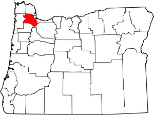 Washington County map | |
| CDPs | ||
| Unincorporated communities |
| |
| Ghost towns | ||
| Footnotes | ‡This populated place also has portions in an adjacent county or counties | |
| ||

| Authority control |
|---|