Wheeler County, Oregon
Wheeler County is a county in the U.S. state of Oregon. As of the 2010 census, the population was 1,441,[1] making it Oregon's least populous county. It is named in honor of Henry H. Wheeler,[2] an early settler who owned a farm near Mitchell. The county seat is Fossil,[3] and Wheeler County is known for having Oregon's largest deposit of fossils.
Wheeler County | |
|---|---|
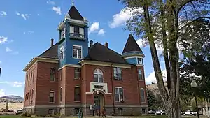 Wheeler County Courthouse in Fossil | |
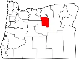 Location within the U.S. state of Oregon | |
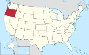 Oregon's location within the U.S. | |
| Coordinates: 44°44′N 120°01′W | |
| Country | |
| State | |
| Founded | February 17, 1899 |
| Seat | Fossil |
| Largest city | Fossil |
| Area | |
| • Total | 1,715 sq mi (4,440 km2) |
| • Land | 1,715 sq mi (4,440 km2) |
| • Water | 0.5 sq mi (1 km2) 0.03%% |
| Population (2010) | |
| • Total | 1,441 |
| • Estimate (2019) | 1,332 |
| • Density | 0.8/sq mi (0.3/km2) |
| Time zone | UTC−8 (Pacific) |
| • Summer (DST) | UTC−7 (PDT) |
| Congressional district | 2nd |
| Website | www |
History
Wheeler County was created on February 17, 1899, from parts of Grant, Gilliam, and Crook Counties. There have been no boundary changes since its creation. Fossil was designated the temporary county seat at the time of the county's creation. In 1900 there was an election to determine the permanent county seat between the three towns of the county, which ended with Fossil winning the election.
Henry H. Miller (born 7 September 1826, Erie County, Pennsylvania - died 26 March 1915, Mitchell, Oregon) arrived in Oregon in 1862, moved around, and settled near Mitchell, Oregon. He married Dorcas L. Monroe on 19 December 1875.[4]
Geography
According to the U.S. Census Bureau, the county has a total area of 1,715 square miles (4,440 km2), of which 1,715 square miles (4,440 km2) is land and 0.5 square miles (1.3 km2) (0.03%) is water.[5]
Adjacent counties
- Gilliam County - north
- Morrow County - northeast
- Grant County - east
- Crook County - south
- Jefferson County - west
- Wasco County - northwest
National Protected Areas
- John Day Fossil Beds National Monument (part)
- Ochoco National Forest (part)
- Umatilla National Forest (part)
Major highway
Demographics
| Historical population | |||
|---|---|---|---|
| Census | Pop. | %± | |
| 1900 | 2,443 | — | |
| 1910 | 2,484 | 1.7% | |
| 1920 | 2,791 | 12.4% | |
| 1930 | 2,799 | 0.3% | |
| 1940 | 2,974 | 6.3% | |
| 1950 | 3,313 | 11.4% | |
| 1960 | 2,722 | −17.8% | |
| 1970 | 1,849 | −32.1% | |
| 1980 | 1,513 | −18.2% | |
| 1990 | 1,396 | −7.7% | |
| 2000 | 1,547 | 10.8% | |
| 2010 | 1,441 | −6.9% | |
| 2019 (est.) | 1,332 | [6] | −7.6% |
| U.S. Decennial Census[7] 1790-1960[8] 1900-1990[9] 1990-2000[10] 2010-2019[1] | |||
2000 census
As of the census[11] of 2000, there were 1,547 people, 653 households, and 444 families living in the county. The population density was 1 people per square mile (0/km2). There were 842 housing units at an average density of 0 per square mile (0/km2). The racial makeup of the county was 93.34% White, 0.06% Black or African American, 0.84% Native American, 0.26% Asian, 0.06% Pacific Islander, 3.49% from other races, and 1.94% from two or more races. 5.11% of the population were Hispanic or Latino of any race. 20.6% were of German, 18.0% English, 13.6% American, 8.2% Irish and 6.9% Scottish ancestry.
There were 653 households, out of which 21.30% had children under the age of 18 living with them, 62.20% were married couples living together, 4.00% had a female householder with no husband present, and 31.90% were non-families. 27.40% of all households were made up of individuals, and 13.30% had someone living alone who was 65 years of age or older. The average household size was 2.32 and the average family size was 2.76.
In the county, the population was spread out, with 22.70% under the age of 18, 3.40% from 18 to 24, 19.30% from 25 to 44, 31.40% from 45 to 64, and 23.30% who were 65 years of age or older. The median age was 48 years. For every 100 females there were 102.20 males. For every 100 females age 18 and over, there were 97.00 males.
The median income for a household in the county was $28,750, and the median income for a family was $34,048. Males had a median income of $29,688 versus $22,361 for females. The per capita income for the county was $15,884. About 12.70% of families and 15.60% of the population were below the poverty line, including 22.20% of those under age 18 and 4.20% of those age 65 or over.
2010 census
As of the 2010 United States Census, there were 1,441 people, 651 households, and 408 families living in the county.[12] The population density was 0.8 inhabitants per square mile (0.31/km2). There were 895 housing units at an average density of 0.5 per square mile (0.19/km2).[13] The racial makeup of the county was 92.4% white, 1.2% American Indian, 0.6% Asian, 0.1% Pacific islander, 2.6% from other races, and 3.1% from two or more races. Those of Hispanic or Latino origin made up 4.3% of the population.[12] In terms of ancestry, 28.4% were German, 24.0% were English, 20.0% were Irish, and 8.4% were American.[14]
Of the 651 households, 20.3% had children under the age of 18 living with them, 51.9% were married couples living together, 7.2% had a female householder with no husband present, 37.3% were non-families, and 32.4% of all households were made up of individuals. The average household size was 2.18 and the average family size was 2.70. The median age was 53.0 years.[12]
The median income for a household in the county was $33,403 and the median income for a family was $43,167. Males had a median income of $36,328 versus $31,792 for females. The per capita income for the county was $20,598. About 9.1% of families and 11.4% of the population were below the poverty line, including 12.0% of those under age 18 and 5.7% of those age 65 or over.[15]
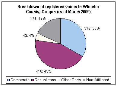
Politics
Though Wheeler County is located in central Oregon, politically it falls in line with the eastern side of the state. The majority of registered voters who are part of a political party in Wheeler County, as well as most counties in eastern Oregon, are members of the Republican Party,[16] and the last Democrat to win a majority in the county was Jimmy Carter in 1976.
In the 2016 presidential election, 72.25 percent of voters went for Republican Donald Trump, 18.95 percent for Democrat Hillary Clinton, 5.62 percent for Libertarian Gary Johnson, and the remainder were either write-ins or voted for other candidates.[17] In the 2012 presidential election, 63.52 percent of voters went for Mitt Romney, 31.00 percent for Barack Obama and 5.48 percent for other candidates. In the 2008 presidential election, 61.33% of Wheeler County voters voted for Republican John McCain, while 34.61% voted for Obama and 4.06% of voters either voted for a Third Party candidate or wrote in a candidate.[18] In the 2004 presidential election, 69.5% of Wheeler Country voters voted for George W. Bush, while 27.8% voted for John Kerry, and 2.7% of voters either voted for a Third Party candidate or wrote in a candidate.[19]
| Year | Republican | Democratic | Third parties |
|---|---|---|---|
| 2020 | 73.7% 711 | 22.5% 217 | 3.8% 37 |
| 2016 | 72.3% 591 | 19.0% 155 | 8.8% 72 |
| 2012 | 63.5% 545 | 31.0% 266 | 5.5% 47 |
| 2008 | 61.3% 498 | 34.6% 281 | 4.1% 33 |
| 2004 | 69.6% 612 | 27.8% 245 | 2.6% 23 |
| 2000 | 69.4% 584 | 24.0% 202 | 6.5% 55 |
| 1996 | 47.8% 418 | 34.2% 299 | 18.0% 157 |
| 1992 | 41.5% 357 | 31.1% 267 | 27.5% 236 |
| 1988 | 54.5% 367 | 40.7% 274 | 4.8% 32 |
| 1984 | 66.6% 504 | 33.4% 253 | 0.0% 0 |
| 1980 | 54.7% 442 | 34.9% 282 | 10.4% 84 |
| 1976 | 45.6% 355 | 51.6% 402 | 2.8% 22 |
| 1972 | 60.3% 474 | 34.0% 267 | 5.7% 45 |
| 1968 | 58.1% 443 | 38.3% 292 | 3.5% 27 |
| 1964 | 42.6% 340 | 57.4% 458 | 0.0% 0 |
| 1960 | 54.8% 566 | 45.2% 466 | 0.0% 0 |
| 1956 | 51.5% 605 | 48.5% 569 | 0.0% 0 |
| 1952 | 60.5% 719 | 39.4% 468 | 0.1% 1 |
| 1948 | 49.2% 414 | 48.9% 411 | 1.9% 16 |
| 1944 | 56.6% 544 | 43.0% 414 | 0.4% 4 |
| 1940 | 51.8% 705 | 47.9% 652 | 0.2% 3 |
| 1936 | 42.2% 502 | 55.7% 663 | 2.1% 25 |
| 1932 | 44.6% 519 | 54.3% 632 | 1.2% 14 |
| 1928 | 75.1% 677 | 24.8% 224 | 0.1% 1 |
| 1924 | 68.4% 685 | 21.3% 213 | 10.3% 103 |
| 1920 | 76.6% 797 | 20.4% 212 | 3.1% 32 |
| 1916 | 51.7% 629 | 46.9% 570 | 1.4% 17 |
| 1912 | 44.8% 307 | 32.4% 222 | 22.9% 157 |
| 1908 | 61.7% 418 | 34.8% 236 | 3.5% 24 |
| 1904 | 69.6% 462 | 24.3% 161 | 6.2% 41 |
| 1900 | 62.0% 426 | 35.4% 243 | 2.6% 18 |
Economy
Principal industries in this county are agriculture, livestock, and lumber.
Communities
Unincorporated communities
- Antone
- Clarno
- Richmond
- Service Creek
- Spoos Mill
- Twickenham
- Waterman
- Wetmore
- City of Wheeler (had a post office Aug 1890-Sept 1895)[4]
- Winlock
Ghost town
Footnotes
- "State & County QuickFacts". United States Census Bureau. Retrieved November 15, 2013.
- "Page:Centennial History of Oregon 1811-1912, Volume 1.djvu/706".
- "Find a County". National Association of Counties. Retrieved June 7, 2011.
- McArthur, Lewis A.; McArthur, Lewis L. (1992) [1928]. Oregon Geographic Names (6th ed.). Portland, Oregon: Oregon Historical Society Press. p. 898. ISBN 978-0875952369.
- "2010 Census Gazetteer Files". United States Census Bureau. August 22, 2012. Retrieved February 28, 2015.
- "Population and Housing Unit Estimates". Retrieved March 26, 2020.
- "U.S. Decennial Census". United States Census Bureau. Retrieved February 28, 2015.
- "Historical Census Browser". University of Virginia Library. Retrieved February 28, 2015.
- Forstall, Richard L., ed. (March 27, 1995). "Population of Counties by Decennial Census: 1900 to 1990". United States Census Bureau. Retrieved February 28, 2015.
- "Census 2000 PHC-T-4. Ranking Tables for Counties: 1990 and 2000" (PDF). United States Census Bureau. April 2, 2001. Retrieved February 28, 2015.
- "U.S. Census website". United States Census Bureau. Retrieved January 31, 2008.
- "DP-1 Profile of General Population and Housing Characteristics: 2010 Demographic Profile Data". United States Census Bureau. Archived from the original on February 13, 2020. Retrieved February 23, 2016.
- "Population, Housing Units, Area, and Density: 2010 - County". United States Census Bureau. Archived from the original on February 13, 2020. Retrieved February 23, 2016.
- "DP02 SELECTED SOCIAL CHARACTERISTICS IN THE UNITED STATES – 2006-2010 American Community Survey 5-Year Estimates". United States Census Bureau. Archived from the original on February 13, 2020. Retrieved February 23, 2016.
- "DP03 SELECTED ECONOMIC CHARACTERISTICS – 2006-2010 American Community Survey 5-Year Estimates". United States Census Bureau. Archived from the original on February 13, 2020. Retrieved February 23, 2016.
- http://records.sos.state.or.us/ORSOSWebDrawer/Recordpdf/6813011 Retrieved on 11/20/2018
- Wheeler County in 2016 Presidential election
- http://uselectionatlas.org/RESULTS/statesub.php?year=2008&fips=41069&f=0&off=0&elect=0 retrieved 4/20/09
- http://www.city-data.com/county/Wheeler_County-OR.html Retrieved on April 21, 2009
- Leip, David. "Dave Leip's Atlas of U.S. Presidential Elections". uselectionatlas.org. Retrieved 2018-04-11.
Further reading
- Mary Fitzgerald, An Independent Folk: A History of Early Wheeler County, Oregon. Mitchell, OR: M. Fitzgerald, 2011.
- F. Smith Fussner (ed.), Glimpses Of Wheeler County's Past: An Early History of North Central Oregon. Portland, OR: Binford and Mort, 1975.
- Janet L Stinchfield and McLaren E Stinchfield, The History of Wheeler County, Oregon. n.c.: Times-Journal, 1983.
- An Illustrated History of Central Oregon, Embracing Wasco, Sherman, Gilliam, Wheeler, Crook, Lake, and Klamath Counties, State of Oregon. Spokane, WA: Western Historical Publishing Co., 1905.
External links
![]() Media related to Wheeler County, Oregon at Wikimedia Commons
Media related to Wheeler County, Oregon at Wikimedia Commons
- Wheeler County Oregon (official website)
- Wheeler County listing in the Oregon Blue Book
Municipalities and communities of Wheeler County, Oregon, United States | ||
|---|---|---|
| Cities | Wheeler County map | |
| Unincorporated communities | ||
| Ghost towns | ||
| ||

| Authority control |
|---|