Rural Municipality of Biggar No. 347
The Rural Municipality of Biggar No. 347 (2016 population: 798) is a rural municipality (RM) in the Canadian province of Saskatchewan within Census Division No. 12 and SARM Division No. 6.
Biggar No. 347 | |
|---|---|
| Rural Municipality of Biggar No. 347 | |
 | |
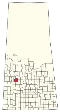 Location of the RM of Biggar No. 347 in Saskatchewan | |
| Coordinates: 52.087°N 108.150°W[1] | |
| Country | Canada |
| Province | Saskatchewan |
| Census division | 12 |
| SARM division | 6 |
| Formed[2] | December 11, 1911 |
| Government | |
| • Reeve | Jeanne Marie de Moissac |
| • Governing body | RM of Biggar No. 347 Council |
| • Administrator | Sandi Silvernagle |
| • Office location | Biggar |
| Area (2016)[4] | |
| • Land | 1,598.56 km2 (617.21 sq mi) |
| Population (2016)[4] | |
| • Total | 798 |
| • Density | 0.5/km2 (1/sq mi) |
| Time zone | CST |
| • Summer (DST) | CST |
| Postal code | S0K 0M0 |
| Area code(s) | 306 and 639 |
| Highway(s) | Highway 4 Highway 14 Highway 51 Highway 658 |
| Railway(s) | Canadian National Railway Canadian Pacific Railway |
History
The RM of Biggar No. 347 incorporated as a rural municipality on December 11, 1911.[2]
Geography
Communities and localities
The following urban municipalities are surrounded by the RM.
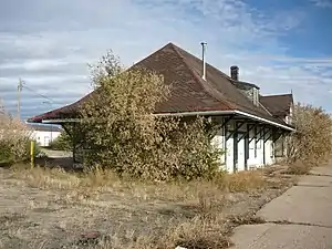
The following unincorporated communities are within the RM.
- Special service areas
- Springwater (dissolved as a village December 31, 2006)[5]
- Localities
Demographics
In the 2016 Census of Population conducted by Statistics Canada, the RM of Biggar No. 347 recorded a population of 798 living in 262 of its 307 total private dwellings, a -2.7% change from its 2011 population of 820. With a land area of 1,598.56 km2 (617.21 sq mi), it had a population density of 0.5/km2 (1.3/sq mi) in 2016.[4]
In the 2011 Census of Population, the RM of Biggar No. 347 recorded a population of 820, a -7% change from its 2006 population of 882. With a land area of 1,598.56 km2 (617.21 sq mi), it had a population density of 0.5/km2 (1.3/sq mi) in 2011.[8]
Government
The RM of Biggar No. 347 is governed by an elected municipal council and an appointed administrator that meets on the third Tuesday of every month.[3] The reeve of the RM is Jeanne Marie de Moissac while its administrator is Sandi Silvernagle.[3] The RM's office is located in Biggar.[3]
References
- "Pre-packaged CSV files - CGN, Canada/Province/Territory (cgn_sk_csv_eng.zip)". Government of Canada. July 24, 2019. Retrieved May 23, 2020.
- "Rural Municipality Incorporations (Alphabetical)". Saskatchewan Ministry of Municipal Affairs. Archived from the original on April 21, 2011. Retrieved May 9, 2020.
- "Municipality Details: RM of Biggar No. 347". Government of Saskatchewan. Retrieved May 21, 2020.
- "Population and dwelling counts, for Canada, provinces and territories, and census subdivisions (municipalities), 2016 and 2011 censuses – 100% data (Saskatchewan)". Statistics Canada. February 8, 2017. Retrieved May 1, 2020.
- "Restructured Villages". Saskatchewan Ministry of Municipal Affairs. Archived from the original on March 25, 2008. Retrieved February 10, 2008.
- "Saskatchewan Census Population" (PDF). Saskatchewan Bureau of Statistics. Archived from the original (PDF) on September 24, 2015. Retrieved May 9, 2020.
- "Saskatchewan Census Population". Saskatchewan Bureau of Statistics. Retrieved May 9, 2020.
- "Population and dwelling counts, for Canada, provinces and territories, and census subdivisions (municipalities), 2011 and 2006 censuses (Saskatchewan)". Statistics Canada. June 3, 2019. Retrieved May 1, 2020.
| Towns | 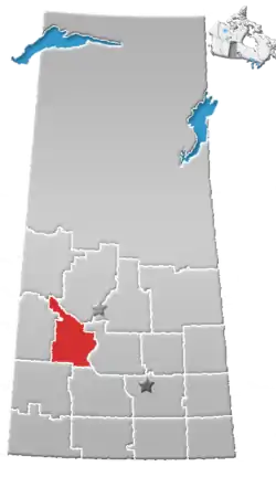 | ||||
|---|---|---|---|---|---|
| Villages | |||||
| Rural municipalities |
| ||||
| First Nations | |||||
| Indian reserves | |||||
| Unincorporated communities |
| ||||