Rural Municipality of Mayfield No. 406
The Rural Municipality of Mayfield No. 406 (2016 population: 377) is a rural municipality (RM) in the Canadian province of Saskatchewan within Census Division No. 16 and SARM Division No. 6.
Mayfield No. 406 | |
|---|---|
| Rural Municipality of Mayfield No. 406 | |
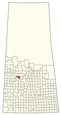 Location of the RM of Mayfield No. 406 in Saskatchewan | |
| Coordinates: 52.574°N 107.852°W[1] | |
| Country | Canada |
| Province | Saskatchewan |
| Census division | 16 |
| SARM division | 6 |
| Formed[2] | December 13, 1909 |
| Government | |
| • Reeve | Craig Hamilton |
| • Governing body | RM of Mayfield No. 406 Council |
| • Administrator | Brenda Appleton |
| • Office location | Maymont |
| Area (2016)[4] | |
| • Land | 782.5 km2 (302.1 sq mi) |
| Population (2016)[4] | |
| • Total | 377 |
| • Density | 0.5/km2 (1/sq mi) |
| Time zone | CST |
| • Summer (DST) | CST |
| Area code(s) | 306 and 639 |
History
The RM of Mayfield No. 406 incorporated as a rural municipality on December 13, 1909.[2] The RM's name is a portmanteau of Maymont and Fielding.[5]
Geography
Demographics
In the 2016 Census of Population conducted by Statistics Canada, the RM of Mayfield No. 406 recorded a population of 377 living in 158 of its 172 total private dwellings, a -3.1% change from its 2011 population of 389. With a land area of 782.5 km2 (302.1 sq mi), it had a population density of 0.5/km2 (1.2/sq mi) in 2016.[4]
In the 2011 Census of Population, the RM of Mayfield No. 406 recorded a population of 389, a -1.3% change from its 2006 population of 394. With a land area of 782.5 km2 (302.1 sq mi), it had a population density of 0.5/km2 (1.3/sq mi) in 2011.[11]
Government
The RM of Mayfield No. 406 is governed by an elected municipal council and an appointed administrator that meets on the second Wednesday of every month.[3] The reeve of the RM is Craig Hamilton while its administrator is Brenda Appleton.[3] The RM's office is located in Maymont.[3]
References
- "Pre-packaged CSV files - CGN, Canada/Province/Territory (cgn_sk_csv_eng.zip)". Government of Canada. July 24, 2019. Retrieved May 23, 2020.
- "Rural Municipality Incorporations (Alphabetical)". Saskatchewan Ministry of Municipal Affairs. Archived from the original on April 21, 2011. Retrieved May 9, 2020.
- "Municipality Details: RM of Mayfield No. 406". Government of Saskatchewan. Retrieved May 21, 2020.
- "Population and dwelling counts, for Canada, provinces and territories, and census subdivisions (municipalities), 2016 and 2011 censuses – 100% data (Saskatchewan)". Statistics Canada. February 8, 2017. Retrieved May 1, 2020.
- Barry, Bill (September 2005). Geographic Names of Saskatchewan. Regina, Saskatchewan: People Places Publishing, Ltd. p. 278. ISBN 1-897010-19-2.
- Saskatchewan Genealogy Association, retrieved March 28, 2008
- Huang, Yj; Powers, R; Montelione, Gt (February 2005), "Statistics", Statistics Canada; Journal of the American Chemical Society, Government of Canada, 127 (6), pp. 1665–74, doi:10.1021/ja047109h, PMID 15701001, retrieved March 28, 2008
- "Mayfield No. 406", Sask biz, Government of Saskatchewan, retrieved March 28, 2008
- "Saskatchewan Census Population" (PDF). Saskatchewan Bureau of Statistics. Archived from the original (PDF) on September 24, 2015. Retrieved May 9, 2020.
- "Saskatchewan Census Population". Saskatchewan Bureau of Statistics. Retrieved May 9, 2020.
- "Population and dwelling counts, for Canada, provinces and territories, and census subdivisions (municipalities), 2011 and 2006 censuses (Saskatchewan)". Statistics Canada. June 3, 2019. Retrieved May 1, 2020.
| Cities | 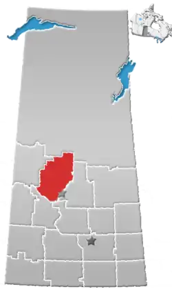 | |
|---|---|---|
| Towns | ||
| Villages | ||
| Resort villages | ||
| Rural municipalities |
| |
| Crown colonies | ||
| First Nations | ||
| Indian reserves |
| |
| Unorganized areas | ||
| Unincorporated communities | ||