Rural Municipality of Frenchman Butte No. 501
The Rural Municipality of Frenchman Butte No. 501 (2016 population: 1,494) is a rural municipality (RM) in the Canadian province of Saskatchewan within Census Division No. 17 and SARM Division No. 6.
Frenchman Butte No. 501 | |
|---|---|
| Rural Municipality of Frenchman Butte No. 501 | |
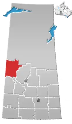
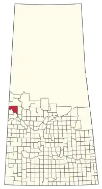 Location of the RM of Frenchman Butte No. 501 in Saskatchewan | |
| Coordinates: 53.585°N 109.647°W[1] | |
| Country | Canada |
| Province | Saskatchewan |
| Census division | 17 |
| SARM division | 6 |
| Formed[2] | January 1, 1954 |
| Government | |
| • Reeve | Barbara Bonnie Mills-Midgley |
| • Governing body | RM of Frenchman Butte No. 501 Council |
| • Administrator | Mae Rotsey |
| • Office location | Paradise Hill |
| Area (2016)[4] | |
| • Land | 1,927.39 km2 (744.17 sq mi) |
| Population (2016)[4] | |
| • Total | 1,494 |
| • Density | 0.8/km2 (2/sq mi) |
| Time zone | CST |
| • Summer (DST) | CST |
| Area code(s) | 306 and 639 |
History
The RM of Frenchman Butte No. 501 incorporated as a rural municipality on January 1, 1954.[2] It was formed through the amalgamation of the RMs of Paradise Hill No. 501 and North Star No. 531 on December 31, 1953.
Geography
Communities and localities
The following urban municipalities are surrounded by the RM.
The following unincorporated communities are within the RM.
- Organized hamlets[5]
- Localities
- Fort Pitt
- Harlan
- Onion Lake
The RM also surrounds Seekaskootch First Nation Indian Reserve No. 119 and borders Makaoo 120.[6]
Demographics
In the 2016 Census of Population conducted by Statistics Canada, the RM of Frenchman Butte No. 501 recorded a population of 1,494 living in 455 of its 544 total private dwellings, a 3.9% change from its 2011 population of 1,438. With a land area of 1,927.39 km2 (744.17 sq mi), it had a population density of 0.8/km2 (2.0/sq mi) in 2016.[4]
In the 2011 Census of Population, the RM of Frenchman Butte No. 501 recorded a population of 1,438, a 17.6% change from its 2006 population of 1,223. With a land area of 1,927.74 km2 (744.30 sq mi), it had a population density of 0.7/km2 (1.9/sq mi) in 2011.[9]
Government
The RM of Frenchman Butte No. 501 is governed by an elected municipal council and an appointed administrator that meets on the second Thursday of every month.[3] The reeve of the RM is Barbara Bonnie Mills-Midgley while its administrator is Mae Rotsey.[3] The RM's office is located in Paradise Hill.[3]
Transportation
- Rail[10]
- North Battleford - Turtleford Branch C.N.R—serves North Battleford, Hamlin, Prince, Meota, Vawn, Edam, Longstaff, Mervin, Turtleford, Cleeves, Spruce Lake, St. Walburg
- Roads[11]
- Highway 797—serves Fort Pitt and Onion Lake and Frenchman Butte
- Highway 21 --
- Highway 26—intersects Highway 3
- Highway 795 --
- Highway 3—serves Paradise Hill
References
- "Pre-packaged CSV files - CGN, Canada/Province/Territory (cgn_sk_csv_eng.zip)". Government of Canada. July 24, 2019. Retrieved May 23, 2020.
- "Rural Municipality Incorporations (Alphabetical)". Saskatchewan Ministry of Municipal Affairs. Archived from the original on April 21, 2011. Retrieved May 9, 2020.
- "Municipality Details: RM of Frenchman Butte No. 501". Government of Saskatchewan. Retrieved May 21, 2020.
- "Population and dwelling counts, for Canada, provinces and territories, and census subdivisions (municipalities), 2016 and 2011 censuses – 100% data (Saskatchewan)". Statistics Canada. February 8, 2017. Retrieved May 1, 2020.
- "2019-2020 Rural Revenue Sharing Organized Hamlet Grant". Government of Saskatchewan. Retrieved May 4, 2020.
- Municipal Relations Division - RM Boundary Changes Archived 2008-01-25 at the Wayback Machine
- "Saskatchewan Census Population" (PDF). Saskatchewan Bureau of Statistics. Archived from the original (PDF) on September 24, 2015. Retrieved May 9, 2020.
- "Saskatchewan Census Population". Saskatchewan Bureau of Statistics. Retrieved May 9, 2020.
- "Population and dwelling counts, for Canada, provinces and territories, and census subdivisions (municipalities), 2011 and 2006 censuses (Saskatchewan)". Statistics Canada. June 3, 2019. Retrieved May 1, 2020.
- Canadian Maps: January 1925 Waghorn's Guide. Post Offices in Man. Sask. Alta. and West Ontario.
- Eversoft Streets and Trips
| Cities |
|  |
|---|---|---|
| Towns | ||
| Villages | ||
| Resort villages | ||
| Rural municipalities |
| |
| First Nations | ||
| Indian reserves | ||
| Unincorporated communities | ||