Tabeguache Peak
Tabeguache Peak is one of the fourteeners of the US state of Colorado. It is a near neighbor of the higher peak Mount Shavano, which lies approximately 1/2 mile (approximately 1 km) to the southeast, and is close to being a subpeak of the latter.[5] According to William Bright an American Linguist specialized in Native American and South Asian languages and descriptive linguistics it is pronounced "TAB-uh-wahch" (/tæbəwɑːtʃ/ (![]() listen)).[6] According to Mountaineer Louis Dawson the name is pronounced "tab-uh-wash," with the accent on the first syllable.[7] It lies just east of the Continental Divide and just west of the Arkansas River, in the south-central part of the Sawatch Range.
It is located within the San Isabel National Forest and is in Chaffee County.
listen)).[6] According to Mountaineer Louis Dawson the name is pronounced "tab-uh-wash," with the accent on the first syllable.[7] It lies just east of the Continental Divide and just west of the Arkansas River, in the south-central part of the Sawatch Range.
It is located within the San Isabel National Forest and is in Chaffee County.
| Tabeguache Peak | |
|---|---|
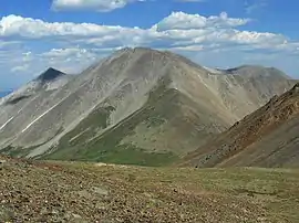 Tabeguache Peak viewed from the west | |
| Highest point | |
| Elevation | 14,162 ft (4,317 m) [1][2] |
| Prominence | 455 ft (139 m) [3] |
| Isolation | 0.75 mi (1.21 km) [3] |
| Listing | Colorado Fourteener 25th |
| Coordinates | 38°37′32″N 106°15′03″W [1] |
| Geography | |
 Tabeguache Peak | |
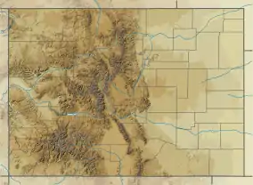
| Location | Chaffee County, Colorado, U.S.[4] |
| Parent range | Sawatch Range[3] |
| Topo map | USGS 7.5' topographic map Saint Elmo, Colorado[1] |
| Climbing | |
| Easiest route | Hike |
The mountain is named for the Tabeguache band of the Utes. "Tabaguache" means 'People of Sun Mountain', from "Tava" meaning 'sun.'[8][9]
Historical names
- Mogwatavungwantsingwu
- Mount Tabequache
- Tabeguache Mountain
- Tageguache Peak – 1982 [4]
References
- "TABEGUACHE". NGS data sheet. U.S. National Geodetic Survey. Retrieved October 22, 2014.
- The elevation of Tabeguache Peak includes an adjustment of +2.107 m (+6.91 ft) from NGVD 29 to NAVD 88.
- "Tabeguache Peak, Colorado". Peakbagger.com. Retrieved October 22, 2014.
- "Tabeguache Peak". Geographic Names Information System. United States Geological Survey. Retrieved October 29, 2014.
- The topographic prominence of Tabeguache Peak is only 435 ft (133 m), and the usual cutoff for independence is 300 ft (91 m).
- William Bright (2004). Colorado Place Names. Johnson Books. ISBN 978-1555663339.
- Louis W. Dawson II (1994). Dawson's Guide to Colorado's Fourteeners, Volume 1. Blue Clover Press. ISBN 0-9628867-1-8.
- Eichler, George R. (1977). Colorado Place Names. Boulder, Colorado: Johnson Publishing Company. LCCN 77-089726.
- Kaelin, Celinda Reynolds (2002). "Tava: A Ute Cultural History". Archived from the original on 24 September 2017.
External links
- Mt. Shavano and Tabeguache Peak on 14ers.com
- Mount Shavano at the Colorado Fourteeners Initiative
- Mount Shavano on fourteeners.org
- "Mount Shavano, Colorado". Peakbagger.com.
