Aliwal Shoal Marine Protected Area
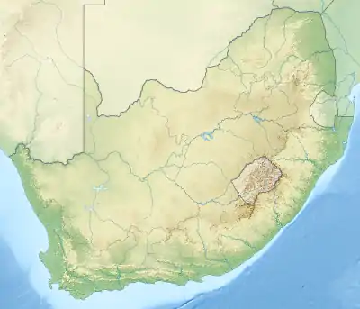
The Aliwal Shoal Marine Protected Area is a coastal and offshore marine protected area between the Lovu and Mzimayi estuaries, off the KwaZulu-Natal South Coast, South Africa.[1]
| Aliwal Shoal Marine Protected Area | |
|---|---|
 Aliwal Shoal MPA location | |
| Location | South coast of kwaZulu-Natal, South Africa |
| Nearest city | Umkomaas and Scottburgh |
| Coordinates | 30°15′S 31°00′E |
| Area | 670 km2 |
| Established | 2004, 2018 |
| Governing body | ?? |
History
The MPA was established in 1991 and proclaimed by the Minister of Environmental Affairs and Tourism, (Marthinus van Schalkwyk, in Government Gazette No. 26431 of 4 June 2004 in terms of section 43 of the) Marine Living Resources Act, 18 of 1998.[2] The Aliwal Shoal MPA was extended by the addition of the large Aliwal Shoal Offshore Marine Protected Area in 2018/2019.[1]
Purpose
A marine protected area is defined by the IUCN as "A clearly defined geographical space, recognised, dedicated and managed, through legal or other effective means, to achieve the long-term conservation of nature with associated ecosystem services and cultural values".[2]
Extent
.png.webp)
.png.webp)
The protected area includes the seabed, subsoil and water column inside the boundaries.[1] Length of coastline protected since 2004 is 18,30 km[2] The area of ocean protected previous to the 2018 extension was 126 km2.[2] now 670 km2.
Zonation
The MPA is divided into an inshore and an offshore area. It is further subdivided into an offshore controlled-pelagic zone, two offshore controlled zones, an inshore controlled zone, an inshore restricted zone, four offshore restricted zones and two inshore sanctuary zones.[1]
Boundaries
The borders of the MPA are:[3]
- Northern boundary from S30°7.000′ E30°51.154′ to S30°7.000′ E31°2.000′
- Eastern boundary from S30°7.000′ E31°2.000′ to S30°22.412′ E31°2.000′
- Southern boundary from S30°22.412′ E31°2.000′ to S30°22.410′ E30°47.530′
- South-western boundary from S30°22.410′ E30°47.530′ to S30°11.920′ E30°48.290′
- Western boundary from S30°11.920′ E30°48.290′ to S30°7.000′ E30°51.154′ along the high-water mark.
Restricted zones
Aliwal Shoal inshore restricted zone:[1]
- Part of the intertidal portion of the Aliwal Shoal Marine Protected Area from S30°14.420’, E30°47.071’ to S30°16.193’, E30°45.814’ between the high water mark and the five meter depth contour.
Aliwal Shoal offshore restricted zone 1:[1]
- Northern boundary: S30°8.5’, E30°52.5’ to S30°8.5’, E31°2’
- Eastern boundary: S30°8.5’, E31°2’ to S30°22.412’, E31°2’
- Southern boundary: S30°22.412’, E31°2’ to S30°22.412’, E30°52.5’
- Western boundary: S30°22.412’, E30°52.5’ to S30°8.5’, E30°52.5’
Aliwal Shoal offshore restricted zone 2:[1]
- Northern boundary: S30°10.8’, E30°49.2’ to S30°10.8’, E30°50.3’
- Eastern boundary: S30°10.8’, E30°50.3’ to S30°11.9’, E30°50.3’
- Southern boundary: S30°11.9’, E30°50.3’ to S30°11.9’, E30°49.2’
- Western boundary: S30°11.9’, E30°49.2’ to S30°10.8’, E30°49.2’
Aliwal Shoal offshore restricted zone 3 (the Produce Restricted Zone):[1]
- Northern boundary: S30°14.968′, E30°49.723′ to S30°14.985′, E30°49.846′
- Eastern boundary: S30°14.985′, E30°49.846′ to S30°15.093′, E30°49.827′
- Southern boundary: S30°15.093′, E30°49.827′ to S30°15.076′, E30°49.703′
- Western boundary: S30°15.076′, E30°49.703′ to S30°14.968′, E30°49.723′
Aliwal Shoal offshore restricted zone 4 (the Crown Area Restricted Zone) is enclosed by twelve line segments between waypoints which lie on the 25 meter isobath.[1]
- S30°15.600′, E30°49.776′ to S30°15.791′, E30°49.714′
- S30°15.791′, E30°49.714′ to S30°15.982′, E30°49.627′
- S30°15.982′, E30°49.627′ to S30°15.982′, E30°49.627′
- S30°16.270′, E30°49.409′ to S30°16.270′, E30°49.409′
- S30°16.673′, E30°49.078′ to S30°16.673′, E30°49.078′
- S30°16.926′, E30°48.835′ to S30°16.926′, E30°48.835′
- S30°16.800′, E30°48.600′ to S30°16.800′, E30°48.600′
- S30°16.680′, E30°48.376′ to S30°16.680′, E30°48.376′
- S30°16.189′, E30°48.834′ to S30°16.189′, E30°48.834′
- S30°15.908′, E30°49.143′ to S30°15.908′, E30°49.143′
- S30°15.518′, E30°49.589′ to S30°15.518′, E30°49.589′
- S30°15.474′, E30°49.671′ to S30°15.474′, E30°49.671′
Controlled zones
Aliwal Shoal inshore controlled zone is the rest of the high-water to five metre isobath inshore portion of the MPA excepting the two sanctuary zones and the restricted zone.[1]
Aliwal Shoal controlled-pelagic zone:[1]
- Northern boundary: S30°8.5’, E30° 50.33’ to S30°8.5’, E30°52.5’
- Eastern boundary: S30°8.5’, E30°52.5’ to S30°17.3’, E30°52.5’
- Southern boundary: S30°17.3’, E30°52.5’ to S30°17.3’, E30°45.586’
- Western boundary S30°17.3’, E30°45.586’ to S30°8.5’, E30° 50.33’
Aliwal Shoal controlled zone 1:[1]
- Northern boundary* S30°7’, E30°51.154’ to S31°7’, E31°2’
- Eastern boundary: S31°7’, E31°2’ to S30°8.5’, E31°2’
- Southern boundary: S30°8.5’, E31°2’ to S30°8.5’, E30°52.5’ to S30°8.5’, E30°50.33’
- Western boundary: S30°8.5’, E30°50.33’ to S30°7’, E30°51.154’ along the five metre depth contour.
Aliwal Shoal controlled zone 2[1]
- Northern boundary: S30°17.3’, E30°45.586’ to S30°17.3’, E30°52.5’
- Eastern boundary: S30°17.3’, E30°52.5’ to S30°22.412’, E30°52.5’
- Southern boundary: S30°22.412’, E30°52.5’ to S30°47’, E30°22’
- Southwestern boundary: S30°47’, E30°22’ to S30°48’, E30°11.9’
- Western boundary: S30°48’, E30°11.9’ to S30°17.3’, E30°45.586’ along the five metre depth contour.
Sanctuary zones
Aliwal Shoal inshore sanctuary zone 1:[1]
- Part of the intertidal portion of the Aliwal Shoal Marine Protected Area, from S30°13.464’, E30°47.694’ to S30°14.420’, E30°47.071’ between the high water mark and the five metre depth contour.
Aliwal Shoal inshore sanctuary zone 2:[1]
- Part of the intertidal portion of the Aliwal Shoal Marine Protected Area, from S30°20.404’, E30°44.003’ to S30°20.807’, E30°43.618’ between the high water mark and the five meter depth contour.
Management
The marine protected areas of South Africa are the responsibility of the national government, which has management agreements with a variety of MPA management authorities, in this case, Ezemvelo KZN Wildlife, which manages the MPA with funding from the SA Government through the Department of Environmental Affairs (DEA).[2]
The Department of Agriculture, Forestry and Fisheries is responsible for issuing permits, quotas and law enforcement.[4]
Use
Fishing
The game and bait fish that be caught in the controlled-pelagic zone of the MPA are in the following families, and all species in these families may be caught.[1]
Pelagic gamefish species:
Pelagic baitfish species:
Scuba diving
Operating a recreational scuba diving business in the MPA requires a permit.[1]
Named dive sites
- Cathedral -30.2644 30.8276
- Eelskin Ridge -30.2634 30.8236
- Fern Coral reef -30.308 30.768
- Howard's Castle -30.282 30.808
- Inside Eelskin -30.2704 30.8201
- Manta Point -30.2599 30.8288
- Northern Pinnacles -30.2616 30.8280
- North Sands -30.2595 30.8275
- Pinnacles -30.2597 30.8280
- Pinnacles -30.2597 30.8280
- Produce wreck -30.2498 30.8296(8)
- Raggies Cave -30.2619 30.8279
- Shark Alley -30.2621 30.8283
- South Sands -30.2636 30.8269
- Stringer -30.2710 30.8237
Geography
Ecology
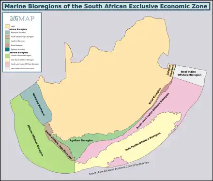
(describe position, biodiversity and endemism of the region) The MPA is in the warm temperate Natal inshore marine bioregion to the north-east of the Mbashe River.[5][6]
Four major habitats exist in the sea in this region, distinguished by the nature of the substrate. The substrate, or base material, is important in that it provides a base to which an organism can anchor itself, which is vitally important for those organisms which need to stay in one particular kind of place. Rocky shores and reefs provide a firm fixed substrate for the attachment of plants and animals. Sandy beaches and bottoms are a relatively unstable substrate and cannot anchor many of the other benthic organisms. Finally there is open water, above the substrate and clear of the kelp forest, where the organisms must drift or swim. Mixed habitats are also frequently found, which are a combination of those mentioned above.[7] There are no significant estuarine habitats in the MPA.
Rocky shores and reefs There are rocky reefs and mixed rocky and sandy bottoms. For many marine organisms the substrate is another type of marine organism, and it is common for several layers to co-exist. Examples of this are red bait pods, which are usually encrusted with sponges, ascidians, bryozoans, anemones, and gastropods, and abalone, which are usually covered by similar seaweeds to those found on the surrounding rocks, usually with a variety of other organisms living on the seaweeds.[7]:Ch.2
The type of rock of the reef is of some importance, as it influences the range of possibilities for the local topography, which in turn influences the range of habitats provided, and therefore the diversity of inhabitants. Sandstone and other sedimentary rocks erode and weather very differently, and depending on the direction of dip and strike, and steepness of the dip, may produce reefs which are relatively flat to very high profile and full of small crevices. These features may be at varying angles to the shoreline and wave fronts. There are fewer large holes, tunnels and crevices in sandstone reefs, but often many deep but low near-horizontal crevices.
Coral reefs
Sedimentary beaches and bottoms (including mud, sand, shelly, pebble and gravel bottoms) Sedimentary bottoms at first glance appear to be fairly barren areas, as they lack the stability to support many of the spectacular reef based species, and the variety of large organisms is relatively low. The sediment is continually being moved around by wave action, to a greater or lesser degree depending on weather conditions and exposure of the area. This means that sessile organisms must be specifically adapted to areas of relatively loose substrate to thrive in them, and the variety of species found on a sandy or gravel bottom will depend on all these factors. unconsolidated sedimentary bottoms have one important compensation for their instability, animals can burrow into the sediment and move up and down within its layers, which can provide feeding opportunities and protection from predation. Other species can dig themselves holes in which to shelter, or may feed by filtering water drawn through the tunnel, or by extending body parts adapted to this function into the water above the sand.[7]:Ch.3
The open sea
Animals
.jpg.webp) Paperfish
Paperfish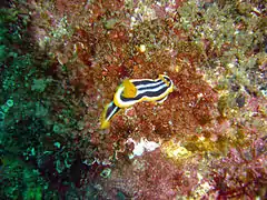 Nudibranch Chromodoris africana
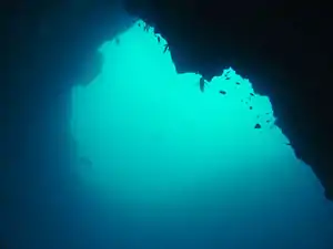 The natural arch at Cathedral dive site
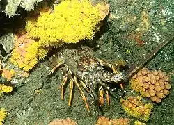 Natal ornate spiny lobster among turret corals
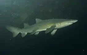 Ragged-tooth shark
_at_Aliwal_Shoal_(5954605150).jpg.webp) Coral rockcod Cephalopholis miniata
Coral rockcod Cephalopholis miniata_at_Aliwal_Shoal_(5954607274).jpg.webp) Boxy Ostracion cubicus
Boxy Ostracion cubicus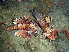 Firefish Pterois miles
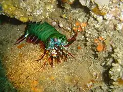 Peacock mantis shrimp
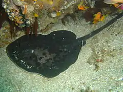 Round ribbontail ray
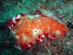 Spanish dancer nudibranch Hexabranchus sanguineus
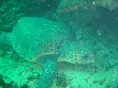 Turtle
Seaweeds
.jpg.webp) Iridescent blues of a Dictotalean brown alga
Iridescent blues of a Dictotalean brown alga
Slipways and harbours in the MPA
There are no harbours in the MPA. Boats are launched directly into the sea from the beach, or when conditions allow, may be launched in a river and navigated through the river mouth.
See also
References
- "R107 Draft Regulations for the management of the Aliwal Shoal Marine Protected Area" (PDF). Regulation Gazette No. 10553. Pretoria: Government Printer. 608 (39646). 3 February 2016.
- "Marine Protected Areas". World Wildlife Fund. Retrieved 24 May 2018.
- "R110 Draft Notice declaring the Aliwal Shoal Marine Protected Area under Section 22A of the National Environmental: Protected Areas Act,2003 (Act No, 57 of 2003)" (PDF). Regulation Gazette No. 10553. Pretoria: Government Printer. 608 (39646). 3 February 2016.
- "Marine Protected Area". Retrieved 26 May 2018.
- Jones, Georgina (2008). A field guide to the marine animals of the Cape Peninsula. Cape Town: SURG. ISBN 978-0-620-41639-9.
- Sink, K.; Harris, J.; Lombard, A. (October 2004). Appendix 1. South African marine bioregions (PDF). South African National Spatial Biodiversity Assessment 2004: Technical Report Vol. 4 Marine Component DRAFT (Report). pp. 97–109.
- Branch, G.M.; Branch, M.L. (1985). The Living Shores of Southern Africa (3rd impression ed.). Cape Town: C. Struik. ISBN 0 86977 115 9.
| |||||||||||||||||||||||||||
| |||||||||||||||||||||||||||
| |||||||||||||||||||||||||||
| |||||||||||||||||||||||||||
| |||||||||||||||||||||||||||
| |||||||||||||||||||||||||||
| |||||||||||||||||||||||||||
| |||||||||||||||||||||||||||
| |||||||||||||||||||||||||||||||||||||
| |||||||||||||||||||||||||||||||||||||
| |||||||||||||||||||||||||||||||||||||
| |||||||||||||||||||||||||||||||||||||
| |||||||||||||||||||||||||||||||||||||
| |||||||||||||||||||||||||||||||||||||
| |||||||||||||||||||||||||||||||||||||
| |||||||||||||||||||||||||||||||||||||
| |||||||||||||||||||||||||||||||||||||
| |||||||||||||||||||||||||||||||||||||
| |||||||||||||||||||||||||||||||||||||
| |||||||||||||||||||||||||||||||||||||
| |||||||||||||||||||||||||||||||||||||
| |||||||||||||||||||||||||||||||||||||
| |||||||||||||||||||||||||||||||||||||