iSimangaliso Marine Protected Area
The iSimangaliso Marine Protected Area is a coastal and offshore marine protected area in KwaZulu-Natal from the South Africa-Mozambique border in the north to Cape St Lucia lighthouse in the south.[1]
| iSimangaliso Marine Protected Area | |
|---|---|
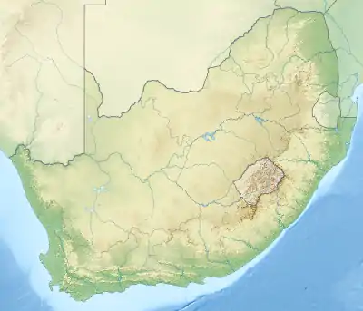 iSimangaliso Marine Protected Area MPA location | |
| Location | Northern kwaZulu-Natal, South Africa |
| Coordinates | 27°41′S 33°03′E |
| Area | 443 km2 (171 sq mi) (original), 10,700 km2 (4,100 sq mi) (total) |
| Established | 2004 |
| Governing body | iSimangaliso Wetland Park Authority |
| World Heritage site | yes |
History
The origins of the MPA were established in 1998.[2] Two existing coastal MPAs, the Maputaland MPA and the St Lucia MPA were combined and a large offshore restricted zone, the iSimangaliso Offshore Marine Protected Area, added in 2019 to become the iSimangaliso MPA.[1]
Purpose
A marine protected area is defined by the IUCN as "A clearly defined geographical space, recognised, dedicated and managed, through legal or other effective means, to achieve the long-term conservation of nature with associated ecosystem services and cultural values".[3]
The offshore extension is intended for the protection of deep water ecosystems and to secure the habitat and foraging areas of endangered Leatherback turtles and coelacanths.[4]
Extent
The length of the protected shoreline is 145 km, and the area of protected ocean is 443 km2[2] The additional offshore controlled area of 10,700 km2 (4,100 sq mi) makes this the largest MPA in the South African network.[4]
Boundaries
The boundaries of the MPA are:[1]
- Northern border: S26°51.515', E32°53.454' to S26º59.376’, E33º27.366′
- Eastern border: S26º59.376’, E33º27.366′ to S28º31.3265’, E33º27.755’
- Southern border: S28º31.3265’, E33º27.755’ to S28°31.174′, E32°24.0587′
- Western border: S28°31.174′, E32°24.0587′ to S26°51.515', E32°53.454' along the high-water mark, excluding estuaries.
Zonation
The Maputaland and St Lucia Marine Reserves form a continuous protected area stretching 150 km from the Mozambique border to Cape Vidal for 3 nautical miles out to sea.[2] These are now part of the iSimangaliso MPA.[1]
Inshore zonation
The inshore zones lie between the high water mark and low water mark, except the controlled pelagic area which extends 100 m seawards of the high water mark.[1]
iSimangaliso inshore sanctuary zone 1: (South African-Mozambique border to 500 m north of the Kosi North Bank)
- An inshore sanctuary zone between the high water and low water marks
- Northern boundary: A line east-south-east from S26°51.5148', E32°53.4527' at the South Africa-Mozambique border
- Southern border: A line bearing east from S26°53.411', E32°52.844'.
iSimangaliso inshore controlled pelagic zone 1: (500 m north of the Kosi north bank to 2 km south of the mouth of the Kosi Lake)
- A controlled pelagic zone between the high water mark and a line 100 m seawards of the high water mark
- Northern boundary: A line bearing east from S26°53.411', E32°52.844'.
- Southern boundary: A line bearing east from S26°54.???', E32°52.847'
iSimangaliso inshore sanctuary zone 2: (2 km south of the mouth of the Kosi Lake to beacon N13)
- An inshore sanctuary zone between the high water and low water marks
- Northern boundary: A line bearing east from S26°54.???', E32°52.847'
- Southern boundary: A line bearing east from S26°56.999', E32°52.349'
iSimangaliso inshore controlled pelagic zone 2: (Beacon N13 to Boteler Point)
- A controlled pelagic zone between the high water mark and a line 100 m seawards of the high water mark
- Northern boundary: A line bearing east from S26°56.999', E32°52.349'
- Southern boundary: A line bearing east from S27°00.835', E32°52.010'
iSimangaliso inshore sanctuary zone 3: (Boteler Point to 1 km south of Dog Point)
- An inshore sanctuary zone between the high water and low water marks
- Northern boundary: A line bearing east from S27°00.835', E32°52.010'
- Southern boundary: A line bearing east from S27°06.935', E32°50.198'
iSimangaliso Inshore Controlled Pelagic Zone 3 (1 km south of Dog Point to north of Sodwana Bay)
- A controlled pelagic zone between the high water mark and a line 100 m seawards of the high water mark
- Northern boundary: A line bearing east from S27°06.935', E32°50.198'
- Southern boundary: A line bearing east from S27°31.583', E32°40.411'
iSimangaliso Inshore Controlled Zone 1: (North of Sodwana Bay to Sodwana lighthouse)
- A controlled area is situated between the high water and low water marks
- Northern boundary: A line bearing east from S27°31.583', E32°40.411'
- Southern boundary: A line bearing east from S27°32.737', E32°40.745'
iSimangaliso Inshore Controlled Pelagic Zone 4: (Sodwana lighthouse to Red Sands)
- A controlled pelagic zone between the high water mark and a line 100 m seawards of the high water mark
- Northern boundary: A line bearing east from S27°31.583', E32°40.411'
- Southern boundary: A line bearing east from S27°43.067', E32°37.610'
iSimangaliso Inshore Wilderness Zone 1: (Red Sands to Leven Point)
- A wilderness area is situated between the high water and low water marks
- Northern boundary: A line bearing east from S27°43.067', E32°37.610'
- Southern boundary: A line bearing east from S27°55.864', E32°35.659'
iSimangaliso Inshore Controlled Pelagic Zone 5: (Leven Point to 4 km north of Cape Vidal)
- A controlled pelagic zone between the high water mark and a line 100 m seawards of the high water mark
- Northern boundary: A line bearing east from S27°55.864', E32°35.659'
- Southern boundary: A line bearing east from S28°05.104', E32°33.616'
iSimangaliso Inshore Controlled Zone 2: (4 km North of Cape Vidal to 1 km south of Cape Vidal)
- A controlled area is situated between the high water and low water marks
- Northern boundary: A line bearing east from S28°05.104', E32°33.616'
- Southern boundary: A line bearing east from S28°08.694', E32°33.306'
iSimangaliso Inshore Controlled Pelagic Zone 6: (1 km south of Cape Vidal to 6.5 km north of Mziki path)
- A controlled pelagic zone between the high water mark and a line 100 m seawards of the high water mark
- Northern boundary: A line bearing east from S28°08.694', E32°33.306'
- Southern boundary: A line bearing east from S28°12.171', E32°31.700'
iSimangaliso Inshore Sanctuary Zone 4: (6.5 km north of Mziki Path to Mziki Path)
- An inshore sanctuary zone between the high water and low water marks
- Northern boundary: A line bearing east from S28°12.171', E32°31.700'
- Southern boundary: A line bearing east from S28°15.335', E32°29.929'
iSimangaliso Inshore Controlled Pelagic Zone 7: (Mziki Path to 2 km north of the St Lucia swimming beach)
- A controlled pelagic zone between the high water mark and a line 100 m seawards of the high water mark
- Northern boundary: A line bearing east from S28°15.335', E32°29.929'
- Southern boundary: A line bearing east from S28°21.???', E32°26.384'
iSimangaliso Inshore Controlled Zone 3: (2 km north of the St Lucia swimming beach to 1.6 km south of Maphelane Point)
- A controlled area is situated between the high water and low water marks
- Northern boundary: A line bearing east from S28°21.???', E32°26.384'
- Southern boundary: A line bearing east from S28°25.356', E32°25.642'
iSimangaliso Inshore Controlled Pelagic Zone 8: (1.6 km south of Maphelane Point to Middle Railway Ledges)
- A controlled pelagic zone between the high water mark and a line 100 m seawards of the high water mark
- Northern boundary: A line bearing east from S28°25.356', E32°25.642'
- Southern boundary: A line bearing east from S28°27.745', E32°25.030'
iSimangaliso Inshore Sanctuary Zone 5: (Middle Railway Ledges to 500 m south of the Cape St Lucia Lighthouse)
- An inshore sanctuary zone between the high water and low water marks
- Northern boundary: A line bearing east from S28°27.745', E32°25.030'
- Southern boundary: A line bearing east from S28°31.171', E32°24.176'
Offshore zonation
The offshore zones are bounded inshore by the low water mark and offshore by a line parallel to the low water mark at a distance of three nautical miles to seaward.[1]
iSimangaliso offshore sanctuary zone 1: (Mozambique border to beacon N13)
- An offshore sanctuary zone between the low water mark and a distance of three nautical miles offshore of the low water mark
- Northern boundary: A line east-south east from S26°51.515', E32°53.453' at the South Africa-Mozambique border
- Southern boundary: A line due east from S26°56.999' E32°52.349'
iSimangaliso offshore controlled pelagic zone 1: (beacon N13 to Boteler Point)
- An offshore controlled pelagic area between the low water mark and a distance of three nautical miles offshore of the low water mark
- Northern boundary: A line due east from S26°56.999', E32°52.349'
- Southern boundary: A line due east from S27°00.835', E32°52.010'
iSimangaliso offshore sanctuary zone 2: (Boteler Point to 1 km south of Dog Point)
- An offshore sanctuary zone between the low water mark and a distance of three nautical miles offshore of the low water mark
- Northern boundary: A line due east from S27°00.835', E32°52.010'
- Southern boundary: A line due east from S27°06.935', E32°50.108'
iSimangaliso offshore controlled pelagic zone 2: (1 km south of Dog Point to north of Sodwana Bay)
- An offshore controlled pelagic area between the low water mark and a distance of three nautical miles offshore of the low water mark
- Northern boundary: A line due east from S27°06.935' E32°50.108'
- Southern boundary: A line due east from S27°31.583', S32°40.411'
iSimangaliso offshore controlled zone 1: (North of Sodwana Bay to the Sodwana lighthouse)
- An offshore controlled zone between the low water mark and a distance of three nautical miles offshore of the low water mark
- Northern boundary: A line due east from S27°31.583', E32°40.411'
- Southern boundary: A line due east from S27°32.737', E32°40.775'
iSimangaliso offshore controlled pelagic zone 3 (Sodwana lighthouse to Red Sands)
- An offshore controlled pelagic area between the low water mark and a distance of three nautical miles offshore of the low water mark
- Northern boundary: A line due east from S27°32.737', E32°40.775'
- Southern boundary: A line due east from S27°43.067', E32°37.610'
iSimangaliso offshore wilderness zone 1: (Red Sands to Leven Point)
- An offshore wilderness zone between the low water mark and a distance of three nautical miles offshore of the low water mark
- Northern boundary: A line due east from S27°43.067', E32°37.610'
- Southern boundary: A line due east from S27°55.864', E32°35.659'
iSimangaliso offshore controlled pelagic zone 4: (Leven Point to 4 km north of the Cape Vidal on-ramp)
- An offshore controlled pelagic area between the low water mark and a distance of three nautical miles offshore of the low water m*An offshore sanctuary zone between the low water mark and a distance of three nautical miles offshore of the low water mark
- Northern boundary: A line due east from S27°55.864', E32°35.659'
- Southern boundary: A line due east from S28°05.184', E32°33.616'
iSimangaliso offshore controlled zone 2: (4 km north of the Cape Vidal on-ramp to 1 km south of Cape Vidal.)
- An offshore controlled zone between the low water mark and a distance of three nautical miles offshore of the low water mark
- Northern boundary: A line due east from S28°05.184', E32°33.616'
- Southern boundary: A line due east from S28°08.694', E32°33.306'
iSimangaliso offshore controlled pelagic zone 5: (1 km south of Cape Vidal to 2 km north of the St Lucia swimming beach)
- An offshore controlled pelagic area between the low water mark and a distance of three nautical miles offshore of the low water mark
- Northern boundary: A line due east from S28°08.694', E32°33.306'
- Southern boundary: A line due east from S28°21.???', E32°26.384'
iSimangaliso offshore controlled zone 3: (2 km north of the St Lucia swimming beach to 1.6 km south of Maphelane Point)
- An offshore controlled zone between the low water mark and a distance of three nautical miles offshore of the low water mark
- Northern boundary: A line due east from S28°21.???', E32°26.384'
- Southern boundary: A line due east from S28°25.356', E32°25.642'
iSimangaliso offshore controlled pelagic zone 6: (1.6 km south of Maphelane Point to 500 m south of the Cape St Lucia Lighthouse)
- An offshore controlled pelagic area between the low water mark and a distance of three nautical miles offshore of the low water mark
- Northern boundary: A line due east from S28°25.356', E32°25.642'
- Southern boundary: A line due east from S28°31.171', E32°24.176'
Restricted areas
The offshore extension area from 3 nautical miles seaward of the low water mark to the offshore boundaries of the MPA.[1]
iSimangaliso offshore restricted zone 1: (offshore extension)
- A restricted area with inshore (western) boundary at three nautical miles from the low water mark from S28°31.345', E32°27.718' to S26°52.356', E32°56.723'
- Northern boundary: S26°52.356', E32°56.723' to S26°58.881', E33°22.345'
- Eastern boundary: S26°58.881', E33°22.345' to S28°31.345', E33°22.345'
- Southern boundary: S28°31.345', E33°22.345' to S28°31.345', E32°27.718'[1]
Management
The marine protected areas of South Africa are the responsibility of the national government, which has management agreements with a variety of MPA management authorities, in this case, the iSimangaliso Wetland Park Authority, which manages the MPA with funding from the SA Government through the Department of Environmental Affairs (DEA).[3][2]
The Department of Agriculture, Forestry and Fisheries is responsible for issuing permits, quotas and law enforcement.[5]
Use
Fishing
The game and bait fish that be caught in the controlled-pelagic zone of the MPA are in the following families, and all species in these families may be caught.[1]
Pelagic gamefish species:
- Carangidae (garrick, kingfish, queenfish, yellowtail)
- Coryphaenidae (dorado)
- Istiophoridae (marlin and sailfish)
- Pomatomidae (elf/shad)
- Rachycentridae (cobia/prodigal son)
- Scombridae (mackerels, tuna, wahoo)
- Sphyraenidae (barracudas)
Pelagic baitfish species:
- Atherinidae (silversides)
- Belonidae (garfish)
- Chirocentridae (wolfherring)
- Clupeidae (red-eyes, sardines)
- Engraulidae (anchovies, glass-noses)
- Exocoetidae (flying fish)
- Hemiramphidae (halfbeaks)
- Scomberesocidae (sauries)
Named dive sites
Some of the dive sites are so close to each other that the available resolution of position does not distinguish between them.
- 1/4 mile Reef (10 m) -27.53 32.68[6]
- Bikini (22 m) -27.53 32.69[6]
- Bikini 2 -27.53 32.69[6]
- Bikini 3 -27.53 32.69[6]
- Bikini North -27.53 32.69[6]
- Hopscotch north (26 m) -27.53 32.69[6]
- Mellow Yellow south (18 m) -27.53 32.69[6]
- 2 mile 2-Buoy (14 m) -27.53 32.69[6]
- 2 mile 2-Buoy block -27.53 32.69[6]
- 2 mile 4-Buoy (14 m) -27.52 32.69[6]
- 2 mile 4-Buoy block -27.52 32.69[6]
- 2 mile Antons (16 m) -27.53 32.68[6]
- 2 mile Antons S tip (16 m) -27.53 32.68[6]
- 2 mile Antons south -27.53 32.68[6]
- 2 mile Arches (14 m) -27.52 32.68[6]
- 2 mile Ash 1 -27.52 32.69[6]
- 2 mile Catt N -27.52 32.69[6]
- 2 mile Catt Reef (18 m) -27.52 32.69[6]
- 2 mile Caves (14 m)-27.53 32.69[6]
- 2 mile Caves -27.53 32.69[6]
- 2 mile Caves & Overhangs 16 m -27.53 32.69[6]
- 2 mile Caves north -27.53 32.69[6]
- 2 mile Chain (14 m) -27.53 32.69[6]
- 2 mile Chain Pieter -27.53 32.69[6]
- 2 mile Coral Gardens (14 m) -27.52 32.69[6]
- 2 mile Grand Central (14 m) -27.52 32.69[6]
- 2 mile Grave (30 m) -27.52 32.69[6]
- 2 mile Hot spots north (30 m) -27.51 32.70[6]
- 2 mile Hot Spots south (30 m) -27.51 32.70[6]
- 2 mile Hotspots (30 m) -27.51 32.70[6]
- 2 mile Pinnacle (14 m) -27.52 32.69[6]
- 2 mile Pinnacles (14 m) -27.52 32.69[6]
- 2 mile Pinnacles block -27.52 32.69[6]
- 2 mile Pinnacles south -27.52 32.69[6]
- 2 mile S-Chain (18 m) -27.53 32.69[6]
- 2 mile Simons -27.52 32.69[6]
- 2 mile Simon's Cave (18 m) -27.52 32.69[6]
- 2 mile Tiles 1 -27.52 32.69[6]
- 2 mile Waynes World -27.52 32.69[6]
- 2 mile Wayne's World (14 m) -27.52 32.69[6]
- 2 mile Zambi Alley (16 m) -27.53 32.69[6]
- 2 outside Deep Sponge (35 m) -27.52 32.7[6]
- 2 outside Deep Sponge / Tombstone (30 m) -27.52 32.69[6]
- 2 outside Deep Sponge 2 (30 m) -27.52 32.69[6]
- 2 outside Sponge (35 m) -27.52 32.69[6]
- 2 outside Sponge (19 m) -27.52 32.69[6]
- 2 Roonies (30 m) -27.52 32.69[6]
- 2 Roonies -27.53 32.69[6]
- 2 Roonies north -27.53 32.69[6]
- 2 Stringer (14 m) -27.53 32.68[6]
- 2 Stringer -27.53 32.70[6]
- 3 mile (23 m) -27.50 32.69[6]
- 3 mile -27.50 32.69[6]
- 3 mile Pin -27.50 32.69[6]
- 5 Canyon (48 m) -27.49 32.70[6]
- 5 Canyon -27.49 32.70[6]
- 5 Canyon Wall (38–46 m) -27.49 32.70[6]
- 5 Fusilier (21 m) -27.49 32.69[6]
- 5 Fusilier -27.49 32.69[6]
- 5 mile (23 m) -27.49 32.69[6]
- 5 mile 5 pin -27.50 32.70[6]
- 5 mile Cabbage 30 m -27.49 32.70[6]
- 5 mile Gotham (46 m) -27.49 32.70[6]
- 5 mile Lettuce - Uniform 30 m -27.50 32.70[6]
- 5 mile Pachycerus (36 m) -27.49 32.7[6]
- 5 mile Pothole (22 m) -27.49 32.69[6]
- 5 mile Ribbon (19 m) -27.49 32.69[6]
- 5 mile Ribbon North (19 m) -27.49 32.69[6]
- 5 mile Ribbon South -27.49 32.69[6]
- 6 mile Snapper College 26 m -27.46 32.71[6]
- 7 mile North 22 m -27.49 32.70[6]
- 7 mile North -27.45 32.71[6]
- 7 mile South (22 m) -27.45 32.71[6]
- 7 mile South -27.45 32.71[6]
- 7-Mile north -27.45 32.71[6]
- 7-Mile northern -27.45 32.71[6]
- 7 mile Amphitheatre (20 m) -27.45 32.71[6]
- 7 mile Castle R -27.45 32.71[6]
- 7 mile Mushroom Rocks (22 m) -27.45 32.71[6]
- 7 mile North Wall (22 m) -27.45 32.71[6]
- 8 mile (19 m) -27.45 32.71[6]
- 8-Mile 2 -27.45 32.71[6]
- 8-Mile 3 -27.44 32.71[6]
- 8 mile Ramsey (18 m) -27.44 32.71[6]
- 9 mile (18 m) -27.41 32.73[6]
- 9 mile 9 tree -27.41 32.73[6]
- 9 mile 9-Mile green tree -27.41 32.73[6]
- 9 mile Breaking Waters (16 m) -27.42 32.72[6]
- 9 mile drop off (23 m) -27.42 32.73[6]
- 9 mile tree -27.41 32.73[6]
- Diepgat South (64 m) -27.61 32.67[6]
Geography
Ecology
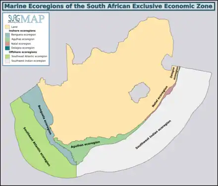
The MPA is in the tropical Delagoa ecoregion in the far north of kwaZulu-Natal[7]
Four major habitats exist in the sea in this region, distinguished by the nature of the substrate. The substrate, or base material, is important in that it provides a base to which an organism can anchor itself, which is vitally important for those organisms which need to stay in one particular kind of place. Rocky shores and reefs provide a firm fixed substrate for the attachment of plants and animals, as do reef building corals. Sandy beaches and sedimentary bottoms are a relatively unstable substrate and cannot anchor many of the benthic organisms. Finally there is open water, above the substrate and clear of the kelp forest, where the organisms must drift or swim. Mixed habitats are also frequently found, which are a combination of those mentioned above.[8] There are no estuarine habitats in the MPA, but several are immediately adjacent.
Rocky shores and reefs There are rocky reefs and mixed rocky and sandy bottoms. For many marine organisms the substrate is another type of marine organism, and it is common for several layers to co-exist.[8]:Ch.2
The type of rock of the reef is of some importance, as it influences the range of possibilities for the local topography, which in turn influences the range of habitats provided, and therefore the diversity of inhabitants. Sandstone and other sedimentary rocks erode and weather very differently, and depending on the direction of dip and strike, and steepness of the dip, may produce reefs which are relatively flat to very high profile and full of small crevices. These features may be at varying angles to the shoreline and wave fronts. There are fewer large holes, tunnels and crevices in sandstone reefs, but often many deep but low near-horizontal crevices.
Coral reefs
Sandy beaches and sedimentary bottoms (including silt, sand, shelly, pebble and gravel bottoms) Sedimentary bottoms at first glance appear to be fairly barren areas, as they lack the stability to support many of the spectacular reef based species, and the variety of large organisms is relatively low. The sediment is continually being moved around by wave action, to a greater or lesser degree depending on weather conditions and exposure of the area. This means that sessile organisms must be specifically adapted to areas of relatively loose substrate to thrive in them, and the variety of species found on a sandy or gravel bottom will depend on all these factors. Sedimentary bottoms have one important compensation for their instability, animals can burrow into the sediment and move up and down within its layers, which can provide feeding opportunities and protection from predation. Other species can dig themselves holes in which to shelter, or may feed by filtering water drawn through the tunnel, or by extending body parts adapted to this function into the water above the sand.[8]:Ch.3
The open sea
Animals
The beaches of the MPA are a nesting site for loggerhead and leatherback turtles.[2]
Endemism
The MPA is in the tropical Delagoa ecoregion in the north of kwaZulu-Natal, which extends from Cape Vidal northwards into Mozambique. There are some species endemic to South Africa along this coastline.[7]
Slipways and harbours in the MPA
There are no harbours or slipways. Beach launches through the surf are standard procedure for fishing and dive boats.
See also
References
- "R118. Draft Regulations for the management of the Isimangaliso Marine Protected Area" (PDF). Regulation Gazette No. 10553. Pretoria: Government Printer. 608 (39646). 3 February 2016.
- "iSimangaliso". World Wildlife Fund. Retrieved 31 January 2019.
- "Marine Protected Areas". World Wildlife Fund. Retrieved 24 May 2018.
- "iSimangaliso's marine protection set to expand as South Africa announces new Marine Protected Area Network". isimangaliso.com. 4 November 2018. Retrieved 5 February 2019.
- "Marine Protected Area". Retrieved 26 May 2018.
- "Standard positions for SeaKeys dive sites: Sodwana Bay". iNaturalist.org. Retrieved 31 January 2019.
- Sink, K.; Harris, J.; Lombard, A. (October 2004). Appendix 1. South African marine bioregions (PDF). South African National Spatial Biodiversity Assessment 2004: Technical Report Vol. 4 Marine Component DRAFT (Report). pp. 97–109.
- Branch, G.M.; Branch, M.L. (1985). The Living Shores of Southern Africa (3rd impression ed.). Cape Town: C. Struik. ISBN 0 86977 115 9.
External links
| |||||||||||||||||||||||||||
| |||||||||||||||||||||||||||
| |||||||||||||||||||||||||||
| |||||||||||||||||||||||||||
| |||||||||||||||||||||||||||
| |||||||||||||||||||||||||||
| |||||||||||||||||||||||||||
| |||||||||||||||||||||||||||
| |||||||||||||||||||||||||||||||||||||
| |||||||||||||||||||||||||||||||||||||
| |||||||||||||||||||||||||||||||||||||
| |||||||||||||||||||||||||||||||||||||
| |||||||||||||||||||||||||||||||||||||
| |||||||||||||||||||||||||||||||||||||
| |||||||||||||||||||||||||||||||||||||
| |||||||||||||||||||||||||||||||||||||
| |||||||||||||||||||||||||||||||||||||
| |||||||||||||||||||||||||||||||||||||
| |||||||||||||||||||||||||||||||||||||
| |||||||||||||||||||||||||||||||||||||
| |||||||||||||||||||||||||||||||||||||
| |||||||||||||||||||||||||||||||||||||
| |||||||||||||||||||||||||||||||||||||