Grade II* listed buildings in Basingstoke and Deane
There are over 20,000 Grade II* listed buildings in England. This page is a list of these buildings in the district of Basingstoke and Deane in Hampshire.
List of buildings
| Name | Location | Type | Completed [note 1] | Date designated | Grid ref.[note 2] Geo-coordinates |
Entry number [note 3] | Image |
|---|---|---|---|---|---|---|---|
| Hill House | Ashford Hill with Headley | Concrete-framed building | 1970–72 | 19 December 2012 | SU5312462142 51°21′21″N 1°14′19″W |
1402215 |  |
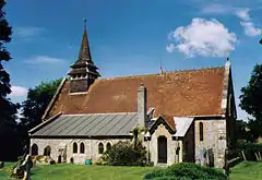
| Church of St Michael | Crux Easton, Ashmansworth | Church | 1775 | 16 May 1966 | SU4247856235 51°18′13″N 1°23′31″W |
1339798 |  Church of St Michael |
| Deanes Almshouses | Basingstoke | Almshouse | 1607 | 3 May 1949 | SU6397851843 51°15′44″N 1°05′04″W |
1339724 |  Deanes Almshouses |
| Ruins of Chapel of the Holy Ghost | Basingstoke | Chapel | Ruin | 3 May 1949 | SU6355452613 51°16′09″N 1°05′25″W |
1092615 |  Ruins of Chapel of the Holy Ghost |
| Ruins of Chapel of the Holy Trinity | Basingstoke | Chapel | Ruin | 3 May 1949 | SU6358052613 51°16′09″N 1°05′24″W |
1230507 | 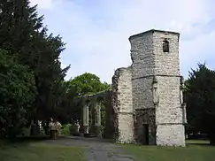 Ruins of Chapel of the Holy Trinity |
| St Thomas House (chapel) | Basingstoke | Chapel | c.1880 | 6 November 1984 | SU6351653093 51°16′24″N 1°05′27″W |
1278440 |  St Thomas House (chapel) |
| Church of St Stephen | Baughurst | Church | 1845 | 16 May 1966 | SU5821059941 51°20′08″N 1°09′57″W |
1092592 |  Church of St Stephen |
| Wolverton House | Wolverton Park, Baughurst | House | 18th century | 16 May 1966 | SU5536658517 51°19′23″N 1°12′25″W |
1092570 |  Wolverton House |
| Church of All Saints | Bradley | Church | 1877 | 26 April 1957 | SU6357541811 51°10′19″N 1°05′31″W |
1093023 | 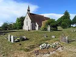 Church of All Saints |
| Bull Down Farmhouse | Bramley Green, Bramley | Farmhouse | 17th century | 26 April 1957 | SU6631258688 51°19′24″N 1°02′59″W |
1156638 | |
| Earlstone Manor | Earlstone Common, Burghclere | Manor house | Late 14th century | 16 May 1966 | SU4795459923 51°20′11″N 1°18′47″W |
1339721 | |
| Manor House | Old Burghclere | Manor house | Mid-14th century | 18 May 1984 | SU4690057889 51°19′05″N 1°19′42″W |
1092540 | |
| Church of St Peter | Brown Candover, Candovers | Church | 1845 | 26 April 1957 | SU5818839707 51°09′13″N 1°10′10″W |
1093001 | 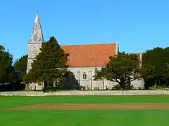 Church of St Peter |
| Church of All Saints | Deane | Church | 1818 | 17 October 1984 | SU5458250237 51°14′55″N 1°13′10″W |
1179721 |  Church of All Saints |
| Church of St Mary | Sydmonton, Ecchinswell, Sydmonton and Bishops Green | Former church | 1849–53 | 16 May 1966 | SU4848657896 51°19′05″N 1°18′20″W |
1092523 | 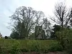 Church of St Mary |
| Sydmonton Court | Sydmonton, Ecchinswell, Sydmonton and Bishops Green | Country house | 16th century | 18 May 1984 | SU4852457951 51°19′07″N 1°18′18″W |
1301426 | |
| Church of St. Martin | Ellisfield | Church | 13th century | 26 April 1957 | SU6386645892 51°12′31″N 1°05′14″W |
1092980 |  Church of St. Martin |
| Manor Farmhouse | Ellisfield | Farmhouse | Late 17th century | 26 April 1957 | SU6386745840 51°12′30″N 1°05′14″W |
1092981 |  Manor Farmhouse |
| Church of St. Andrew | Farleigh Wallop | Church | 1750 | 26 April 1957 | SU6251747526 51°13′25″N 1°06′22″W |
1302322 |  Church of St. Andrew |
| Farleigh Wallop House | Farleigh Wallop | House | 1731 | 26 April 1957 | SU6214446660 51°12′57″N 1°06′42″W |
1339532 | |
| Pembrokes | Hartley Wespall | House | Early 17th century | 17 October 1984 | SU6935358382 51°19′13″N 1°00′22″W |
1178752 | |
| Church of St. Mary | Herriard | Church | 13th century | 26 April 1957 | SU6637546010 51°12′34″N 1°03′04″W |
1339500 | 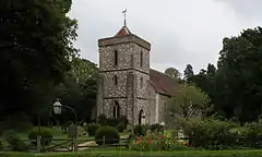 Church of St. Mary |
| Church of St Michael Archangel | Highclere | Church | 1870 | 16 May 1966 | SU4401760298 51°20′24″N 1°22′10″W |
1339760 |  Church of St Michael Archangel |
| Heaven's Gate | Highclere Gate, Highclere | Garden feature | Mid-18th century | 16 May 1966 | SU4459657629 51°18′58″N 1°21′41″W |
1339737 | |
| London Lodge | Highclere Park, Highclere | Gate | 1793 | 16 May 1966 | SU4587260373 51°20′26″N 1°20′34″W |
1166538 | |
| The Temple | Highclere Park, Highclere | Folly | c.1760 | 16 May 1966 | SU4555860084 51°20′17″N 1°20′51″W |
1166518 |  The Temple |
| Church of St Andrew | Hurstbourne Priors | Church | 12th century | 16 May 1966 | SU4391846661 51°13′03″N 1°22′21″W |
1339806 | 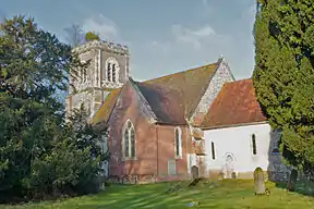 Church of St Andrew |
| The Bee House | Hurstbourne Park, Hurstbourne Priors | House | Late 19th century | 30 May 1984 | SU4419846379 51°12′54″N 1°22′07″W |
1175623 | |
| Church of St Mary | Kingsclere | Church | 12th century | 16 May 1966 | SU5252158657 51°19′29″N 1°14′52″W |
1092447 |  Church of St Mary |
| 20 Swan Street | Kingsclere | House | 18th century | 18 May 1984 | SU5247358552 51°19′25″N 1°14′54″W |
1167623 | |
| Laverstoke House | Laverstoke Park, Laverstoke | House | 1798 | 10 January 1953 | SU4933849054 51°14′19″N 1°17′41″W |
1339659 |  Laverstoke House |
| Church of St James | Litchfield, Litchfield and Woodcott | Church | Norman | 16 May 1966 | SU4616054030 51°17′01″N 1°20′22″W |
1308204 |  Church of St James |
| Church of St. Mary | Mapledurwell and Up Nately | Church | 13th century | 26 April 1957 | SU6874550973 51°15′14″N 1°00′59″W |
1092979 |  Church of St. Mary |
| Church of St. Stephen | Mapledurwell and Up Nately | Church | c.1200 | 26 April 1957 | SU7006951971 51°15′45″N 0°59′50″W |
1092941 |  Church of St. Stephen |
| Countess of Huntingdon's Chapel | Mortimer West End | Chapel | 1805 | 25 April 1980 | SU6166164187 51°22′24″N 1°06′56″W |
1339519 |  Countess of Huntingdon's Chapel |
| Church of St. Leonard | Oakley | Church | Early 16th century | 26 April 1957 | SU5673350343 51°14′58″N 1°11′19″W |
1301811 | 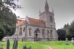 Church of St. Leonard |
| Barn to south of South Litchfield Grange | Overton | Barn | 17th century | 12 April 1984 | SU5307045855 51°12′34″N 1°14′30″W |
1092664 | |
| Chapel | Quidhampton, Overton | Chapel | Norman | 10 January 1953 | SU5184150428 51°15′02″N 1°15′31″W |
1092696 |  Chapel |
| Church of St Mary | Overton | Church | Medieval | 16 May 1966 | SU5146349985 51°14′48″N 1°15′51″W |
1302540 |  Church of St Mary |
| Court Farmhouse | Overton | Farmhouse | 16th century | 16 May 1966 | SU5136449991 51°14′48″N 1°15′56″W |
1339662 |  Court Farmhouse |
| Wyeford Farm House | Pamber | Farmhouse | Early 17th century | 26 April 1957 | SU5997258885 51°19′33″N 1°08′26″W |
1301155 | |
| North Hall | Preston Candover | House | 1794 | 26 April 1957 | SU6041541578 51°10′13″N 1°08′14″W |
1092845 | |
| Remains of the Church of St Mary | Preston Candover | Church | 12th century | 26 April 1957 | SU6036541402 51°10′07″N 1°08′17″W |
1092852 | |
| Church of St. Nicholas | Steventon | Cross | 13th century | 26 April 1957 | SU5510147226 51°13′18″N 1°12′45″W |
1092810 | 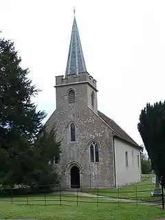 Church of St. Nicholas |
| Bridge over the River Loddon | Stratfield Saye Park, Stratfield Turgis | Bridge | 1802 | 26 April 1957 | SU6966961191 51°20′44″N 1°00′04″W |
1092776 |  Bridge over the River Loddon |
| Church of All Saints | Tunworth | Church | 12th century | 26 April 1957 | SU6734248445 51°13′52″N 1°02′13″W |
1092788 | 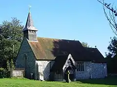 Church of All Saints |
| Hoddington House | Hoddington Park, Upton Grey | House | Late 17th century | 26 April 1957 | SU7009247855 51°13′32″N 0°59′51″W |
1092759 | |
| St Lawrence's Church, Weston Patrick | Weston Patrick | Church | 12th century | 26 April 1957 | SU6909446891 51°13′01″N 1°00′44″W |
1092728 | |
| Church of All Hallows | Whitchurch | Church | Norman | 16 May 1966 | SU4599447748 51°13′37″N 1°20′34″W |
1339652 | 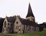 Church of All Hallows |
| The Silk Mill | Whitchurch | Brush factory | c.1800 | 10 January 1953 | SU4625547899 51°13′42″N 1°20′20″W |
1092645 | |
| Town Hall | Whitchurch | Town hall | Late 18th century | 10 January 1953 | SU4624348094 51°13′49″N 1°20′21″W |
1092680 |  Town Hall |
| Hackwood House | Hackwood Park, Winslade | Country house | 1680 | 26 April 1957 | SU6470049633 51°14′32″N 1°04′28″W |
1092734 | 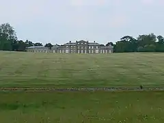 Hackwood House |
| Stable block and riding school | Hackwood Park, Winslade | Courtyard | Early 19th century | 26 April 1957 | SU6451449875 51°14′40″N 1°04′38″W |
1296483 |  Stable block and riding school |
| The Menagerie Pond Pavilion | Hackwood Park (Spring Park), Winslade | Pavilion | 18th century | 26 April 1957 | SU6506249464 51°14′26″N 1°04′10″W |
1092740 | |
| Church of St. Lawrence | Wootton St Lawrence | Church | Norman | 26 April 1957 | SU5921253221 51°16′30″N 1°09′09″W |
1092711 | 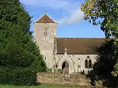 Church of St. Lawrence |
| Tangier House | Wootton St. Lawrence | House | 1662 | 26 April 1957 | SU5816953161 51°16′29″N 1°10′03″W |
1092712 | |
| Worting House | Worting | House | Late 18th century | 3 May 1949 | SU5994352004 51°15′51″N 1°08′32″W |
1339701 |  Worting House |
_-_geograph.org.uk_-_377290.jpg.webp)

Notes
- The date given is the date used by Historic England as significant for the initial building or that of an important part in the structure's description.
- Sometimes known as OSGB36, the grid reference is based on the British national grid reference system used by the Ordnance Survey.
- The "List Entry Number" is a unique number assigned to each listed building and scheduled monument by Historic England.
External links
This article is issued from Wikipedia. The text is licensed under Creative Commons - Attribution - Sharealike. Additional terms may apply for the media files.