Grade II* listed buildings in Brentwood (borough)
There are over 20,000 Grade II* listed buildings in England. This page is a list of these buildings in the district of Brentwood in Essex.
List of buildings
| Name | Location | Type | Completed [note 1] | Date designated | Grid ref.[note 2] Geo-coordinates |
Entry number [note 3] | Image |
|---|---|---|---|---|---|---|---|
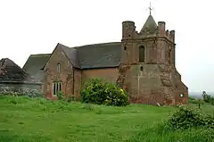
| Church of St Nicholas | Ingrave, Herongate and Ingrave | Parish church | 1734 | 21 October 1958 | TQ6232792024 51°36′13″N 0°20′33″E |
1205640 | 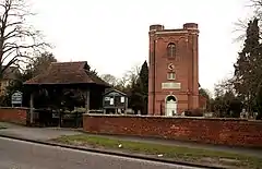 Church of St Nicholas |
| Granary 5 metres south-east of Heron Hall | Herongate, Herongate and Ingrave | Granary | Early 15th century | 21 October 1958 | TQ6392491751 51°36′03″N 0°21′56″E |
1280702 |  |
| Fryerning Hall | Fryerning, Ingatestone and Fryerning | House | 17th century | 29 December 1952 | TL6392600191 51°40′36″N 0°22′10″E |
1052243 | |
| Gatehouse and courtyard ranges 30 metres west of Ingatestone Hall | Ingatestone, Ingatestone and Fryerning | Jettied gatehouse | 16th century | 29 December 1952 | TQ6534098550 51°39′41″N 0°23′21″E |
1197286 |  Gatehouse and courtyard ranges 30 metres west of Ingatestone Hall |
| Granary 130 metres north-west of Ingatestone Hall | Ingatestone, Ingatestone and Fryerning | Granary | Late 16th century | 29 December 1952 | TQ6530298626 51°39′44″N 0°23′19″E |
1298752 | |
| Mill Green Windmill | Mill Green, Ingatestone and Fryerning | Post mill | 1759 | 20 December 1952 | TL6396700741 51°40′53″N 0°22′13″E |
1297199 | |
| 98 High Street | Ingatestone, Ingatestone and Fryerning | House | Early 18th century | 10 April 1967 | TQ6497699546 51°40′14″N 0°23′04″E |
1297194 |  98 High Street |
| Hatch Farmhouse | Kelvedon Hatch | Farmhouse | Mid-16th century | 27 August 1952 | TQ5697898979 51°40′04″N 0°16′07″E |
1197316 | |
| Mountnessing Windmill | Mountnessing | Mill | 1807 | 29 December 1952 | TQ6309997967 51°39′25″N 0°21′23″E |
1293205 | |
| Church of All Saints | East Horndon, West Horndon | Church | 15th century with earlier fragments | 21 October 1958 | TQ6355889524 51°34′51″N 0°21′33″E |
1197184 | |
| Little Warley Hall | Little Warley, West Horndon | House | Early 16th century | 21 October 1958 | TQ6043288571 51°34′23″N 0°18′49″E |
1197230 | |
| Chantry Chapel and Mausoleum | Thorndon Park | Chapel | c.1850 | 20 February 1976 | TQ6148091443 51°35′55″N 0°19′48″E |
1293260 | 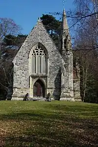 Chantry Chapel and Mausoleum |
| Church of St Mary the Virgin | Shenfield | Parish church | 15th century | 21 October 1958 | TQ6055795127 51°37′55″N 0°19′06″E |
1197213 | .jpg.webp) Church of St Mary the Virgin |
| Church of St Thomas of Canterbury | Brentwood | Church | 1881–87 | 20 February 1976 | TQ5965093722 51°37′11″N 0°18′17″E |
1197244 |  Church of St Thomas of Canterbury |
| Lych gate at Church of St Mary the Virgin | Great Warley | Lych gate | 1903 | 16 March 1993 | TQ5892289995 51°35′11″N 0°17′33″E |
1206677 |  Lych gate at Church of St Mary the Virgin |
| Great Ropers | Great Warley | House | Late 18th century | 21 October 1958 | TQ5859791517 51°36′01″N 0°17′19″E |
1206489 | |
| Two Door Cottage | Great Warley | House | 18th century | 21 October 1958 | TQ5836790668 51°35′33″N 0°17′05″E |
1197209 |  Two Door Cottage |
| Church of All Saints | Hutton | Church | Early 14th century | 21 October 1958 | TQ6352194340 51°37′27″N 0°21′39″E |
1297263 | 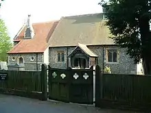 Church of All Saints |
| Hutton Hall and attached stable block | Hutton | House | 17th century | 21 October 1958 | TQ6343094464 51°37′31″N 0°21′35″E |
1280481 | |
| Church of St Peter | South Weald | Church | 12th century and later | 21 October 1958 | TQ5713093869 51°37′18″N 0°16′06″E |
1297216 |  Church of St Peter |
| Moat House | South Weald | House | Early 16th century onwards | 21 October 1958 | TQ5787492897 51°38′00″N 0°19′39″E |
1279743 |  Moat House |
| The Golden Fleece Inn | South Weald | House | c.1400 | 21 October 1958 | TQ5777892916 51°36′47″N 0°16′38″E |
1197231 | |
| Rosebrook | Childerditch | House | 17th century | 20 February 1976 | TQ6146090233 51°35′16″N 0°19′45″E |
1197195 | |
| Stable 5 metres south east of Lincolns | Pilgrims Hatch | Kitchen | c.1500 | 16 April 1986 | TQ5624295463 51°38′11″N 0°15′23″E |
1207388 | 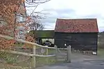 Stable 5 metres south east of Lincolns |
| Roden House | Shenfield Rd, Brentwood | House | By 1717 | 21 October 1958 | TQ5978293917 51°37′17″N 0°18′24″E |
1208008 | |
| The Old House | Shenfield Rd, Brentwood | House | c.1600 | 21 October 1958 | TQ5973293955 51°37′18″N 0°18′22″E |
1197251 | |
| White Hart Inn | Brentwood | Inn | Late 15th century | 21 October 1958 | TQ5933493750 51°37′12″N 0°18′01″E |
1372317 |  White Hart Inn |


Notes
- The date given is the date used by Historic England as significant for the initial building or that of an important part in the structure's description.
- Sometimes known as OSGB36, the grid reference is based on the British national grid reference system used by the Ordnance Survey.
- The "List Entry Number" is a unique number assigned to each listed building and scheduled monument by Historic England.
External links
This article is issued from Wikipedia. The text is licensed under Creative Commons - Attribution - Sharealike. Additional terms may apply for the media files.