Grade II* listed buildings in Breckland
There are over 20,000 Grade II* listed buildings in England. This page is a list of 102 of these buildings in the district of Breckland in Norfolk.
List of buildings
| Name | Location | Type | Completed [note 1] | Date designated | Grid ref.[note 2] Geo-coordinates |
Entry number [note 3] | Image |
|---|---|---|---|---|---|---|---|
| Attleborough Hall | Attleborough | Country house | 16th century | 21 July 1951 | TM0504896273 52°31′33″N 1°01′16″E |
1342452 |  Attleborough Hall |
| Bridge and walls to moat at Attleborough Hall | Attleborough | Bridge | Mid-16th century | 1 October 1979 | TM0510796286 52°31′33″N 1°01′20″E |
1169012 |  |
| Banham Hall | Banham | Manor house | Late 16th century | 21 July 1951 | TM0698389129 52°27′39″N 1°02′43″E |
1306687 |  Banham Hall |
| Kings Head Cottage | Banham | House | 17th century | 9 February 1984 | TM0656287619 52°26′51″N 1°02′17″E |
1342453 | |
| Church of St Peter | Bittering, Beeston with Bittering | Parish church | 12th and 13th century | 30 May 1960 | TF9376817526 52°43′14″N 0°52′03″E |
1342520 | _-_geograph.org.uk_-_607257.jpg.webp) Church of St Peter |
| Church of St Mary | East Bilney, Beetley | Church | 14th century | 30 May 1960 | TF9553419536 52°44′17″N 0°53′42″E |
1342554 |  Church of St Mary |
| Church of St Swithin | Bintree | Parish church | 14th century | 30 May 1960 | TG0171623446 52°46′15″N 0°59′20″E |
1077371 | 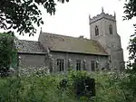 Church of St Swithin |
| Blo' Norton Hall | Blo' Norton | Country house | Mid-16th century | 21 July 1951 | TM0082679633 52°22′40″N 0°56′57″E |
1077439 | 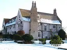 Blo' Norton Hall |
| Church Farmhouse | Blo' Norton | Farmhouse | Late 15th century | 21 July 1951 | TM0121279795 52°22′45″N 0°57′17″E |
1077441 |  Church Farmhouse |
| Church of St Andrew | Blo' Norton | Parish church | 13th century | 16 July 1958 | TM0122279698 52°22′42″N 0°57′18″E |
1077440 | 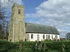 Church of St Andrew |
| Clock tower to north of Shadwell Court | Brettenham | Clock tower | 1856–60 | 18 March 1983 | TL9286883163 52°24′45″N 0°50′04″E |
1342781 | |
| The College | Brettenham | House | 19th century | 21 July 1951 | TL9238881217 52°23′43″N 0°49′34″E |
1076907 |  The College |
| Church of St Mary | Bridgham | Parish church | 14th century | 16 July 1958 | TL9577385826 52°26′07″N 0°52′43″E |
1076909 | 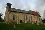 Church of St Mary |
| Brisley Hall | Brisley | Farmhouse | 17th century and earlier | 4 December 1951 | TF9527621374 52°45′17″N 0°53′32″E |
1342482 | |
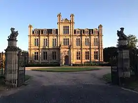
| Bylaugh Hall | Bylaugh Park, Bylaugh | Country house | 1850–52 | 15 April 1982 | TG0353618751 52°43′41″N 1°00′46″E |
1077349 | |
| Farm buildings at Park Farm | Bylaugh | Farm buildings | c.1850 | 15 May 1999 | TG0301118424 52°43′31″N 1°00′17″E |
1379764 | |
| Caston Windmill and Granary | Caston | Mill | 1864 | 21 July 1951 | TL9511198159 52°32′47″N 0°52′34″E |
1076787 | |
| Church of All Saints | Cockley Cley | Parish church | 13th century and later | 23 June 1960 | TF7917804186 52°36′21″N 0°38′41″E |
1077261 | 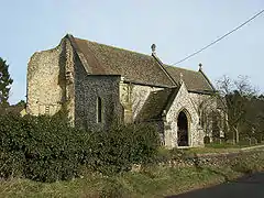 Church of All Saints |
| Church of St Mary | Colkirk | Parish church | 14th century and later | 30 May 1960 | TF9178526549 52°48′09″N 0°50′37″E |
1077464 | 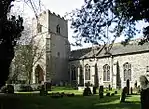 Church of St Mary |
| Hall Farmhouse | Colkirk | Farmhouse | 16th century | 4 December 1951 | TF9245426676 52°48′12″N 0°51′13″E |
1304756 |  Hall Farmhouse |
| Pattesley House | Pattesley, Colkirk | Farmhouse | 14th century and later | 4 December 1951 | TF8984424107 52°46′52″N 0°48′48″E |
1077468 | |
| Church of St Andrew | Southburgh, Cranworth | Parish church | 14th century and later | 30 May 1960 | TG0032104832 52°36′16″N 0°57′24″E |
1172040 |  Church of St Andrew |
| Letton Hall | Cranworth | Country house | 1783–89 | 4 December 1951 | TF9717605872 52°36′53″N 0°54′40″E |
1077342 | 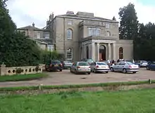 Letton Hall |
| Dereham Maltings (Crisp Malting Group) | Dereham | Industrial building | 1870 and 1894 | 27 July 2000 | TF9941913130 52°40′45″N 0°56′55″E |
1246348 |  Dereham Maltings (Crisp Malting Group) |
| West Hall | Didlington | House | 17th century | 18 February 1987 | TL7977294025 52°30′52″N 0°38′52″E |
1171962 | |
| Old Hall | East Tuddenham | Farmhouse | 16th century | 4 December 1951 | TG0880711092 52°39′26″N 1°05′09″E |
1077351 | |
| Church of St Thomas | Foxley | Parish church | 14th century and later | 30 May 1960 | TG0395221714 52°45′16″N 1°01′15″E |
1169955 | 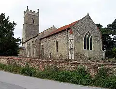 Church of St Thomas |
| Church of All Saints | Great Fransham, Fransham | Parish church | Late 13th century and later | 30 May 1960 | TF8989013104 52°40′56″N 0°48′28″E |
1077471 |  Church of All Saints |
| Hyde Hall | Great Fransham, Fransham | Farmhouse | Mid-18th century | 14 June 1984 | TF9163412919 52°40′48″N 0°50′00″E |
1077469 | |
| The Old Hall | Little Fransham, Fransham | Farmhouse | 16th century | 4 December 1951 | TF9028111866 52°40′16″N 0°48′46″E |
1152599 | |
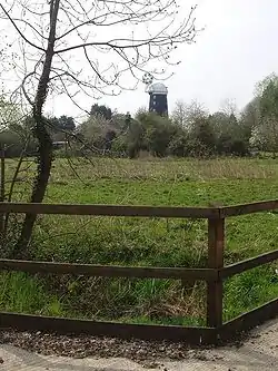
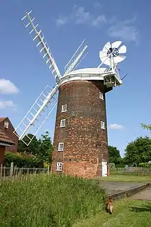
| Garboldisham Windmill | Garboldisham | Windmill | c.1780 | 16 July 1958 | TM0027580472 52°23′08″N 0°56′29″E |
1168497 | |
| Jacques | Garboldisham | Cross passage house | c.1490 | 21 July 1951 | TM0035181964 52°23′56″N 0°56′37″E |
1077445 | |
| Church of St Margaret | Garvestone | Parish church | 14th century | 30 May 1960 | TG0238207362 52°37′35″N 0°59′19″E |
1305274 |  Church of St Margaret |
| Guntons Farmhouse | Garvestone | Farmhouse | 18th century | 4 December 1951 | TG0162906868 52°37′20″N 0°58′38″E |
1342566 | |
| Reymerston Old Hall Farmhouse | Reymerston, Garvestone | Farmhouse | 1620 | 4 December 1951 | TG0144206352 52°37′03″N 0°58′27″E |
1342565 | |
| Church of St Andrew | Guist | Parish church | 13th century and later | 30 May 1960 | TG0002025606 52°47′27″N 0°57′54″E |
1306255 |  Church of St Andrew |
| Church of St Mary | Bodney, Hilborough | Parish church | 14th century and later | 23 June 1960 | TL8311898835 52°33′24″N 0°41′59″E |
1077285 |  Church of St Mary |
| Hilborough Hall | Hilborough | House | 1779 | 9 July 1951 | TF8276700304 52°34′11″N 0°41′43″E |
1077283 |  Hilborough Hall |
| Hilborough Mill | Hilborough | Mill house | 1819 | 30 October 1985 | TL8272699928 52°33′59″N 0°41′41″E |
1342591 |  Hilborough Mill |
| Church of St Andrew | Hoe | Parish church | 13th century | 30 May 1960 | TF9975616421 52°42′31″N 0°57′20″E |
1077329 |  Church of St Andrew |
| Church of St Margaret | Worthing, Hoe | Parish church | 12th century and later | 30 May 1960 | TF9949619530 52°44′12″N 0°57′13″E |
1342577 | 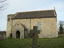 Church of St Margaret |
| Church of St Edmund | Horningtoft | Parish church | 13th century | 14 June 1984 | TF9361323080 52°46′14″N 0°52′07″E |
1304480 | 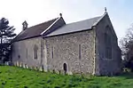 Church of St Edmund |
| Church of St Peter | Ickburgh | Parish church | 14th century | 23 June 1960 | TL8164495067 52°31′24″N 0°40′34″E |
1077286 |  Church of St Peter |
| Kenninghall Place | Kenninghall | House | 1505–25 | 21 July 1951 | TM0691785620 52°25′46″N 1°02′32″E |
1077419 | |
| Church of St Andrew | Kilverstone | Parish church | 12th century | 16 July 1958 | TL8938684014 52°25′17″N 0°47′01″E |
1342788 |  Church of St Andrew |
| Church of St Nicholas | West Lexham, Lexham | Parish church | 14th century, restored 1891 | 30 May 1960 | TF8425617211 52°43′16″N 0°43′36″E |
1077485 | 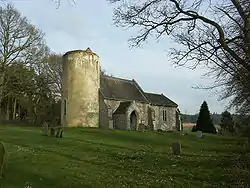 Church of St Nicholas |
| Pumphouse | Little Cressingham | Pump house | Early 19th century | 3 April 1987 | TF8696700215 52°34′03″N 0°45′26″E |
1077226 |  Pumphouse |
| Wind and Water Mill | Little Cressingham | Watermill | c.1820 | 9 July 1951 | TF8697900213 52°34′03″N 0°45′27″E |
1152133 | 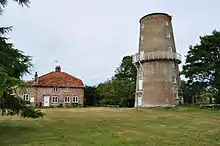 Wind and Water Mill |
| Dunham Lodge | Little Dunham | Country house | 1783 | 4 December 1951 | TF8772912849 52°40′51″N 0°46′32″E |
1077493 |  Dunham Lodge |
| Church of St Peter | Little Ellingham | Parish church | Early 14th century | 16 November 1983 | TM0050899155 52°33′12″N 0°57′22″E |
1342423 |  Church of St Peter |
| Church of St Andrew and St Peter | Longham | Parish church | 15th century and later | 30 May 1960 | TF9318716189 52°42′32″N 0°51′30″E |
1077331 | 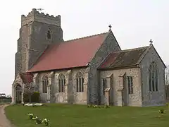 Church of St Andrew and St Peter |
| Church of Our Lady of Consolation | Lynford | Roman Catholic church | 1879 | 18 February 1987 | TL8188293306 52°30′26″N 0°40′43″E |
1077247 | 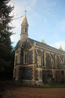 Church of Our Lady of Consolation |
| Church of St Margaret | Lyng | Parish church | 13th century and later | 30 May 1960 | TG0690617855 52°43′08″N 1°03′43″E |
1169125 | 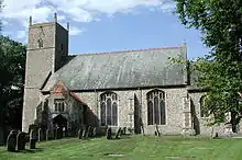 Church of St Margaret |
| Ivy Farmhouse | Mattishall | House | First half of 18th century | 4 December 1951 | TG0437610901 52°39′26″N 1°01′13″E |
1077328 | |
| Merton Hall Gatehouse | Merton | Gatehouse | 1620 | 21 July 1951 | TL9111697765 52°32′39″N 0°49′01″E |
1076830 | .jpg.webp) Merton Hall Gatehouse |
| Cross in the churchyard 10 metres west of tower of Church of St John the Baptist | Mileham | Cross | 15th century | 14 June 1984 | TF9217619584 52°44′23″N 0°50′43″E |
1342489 | |
| Church of St Leonard | Mundford | Parish church | 14th century | 23 June 1960 | TL8005293801 52°30′44″N 0°39′07″E |
1342617 | 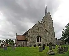 Church of St Leonard |
| Narborough Hall | Narborough | Country house | Late 16th century | 9 July 1951 | TF7493713142 52°41′16″N 0°35′12″E |
1077305 | |
| Table tomb approximately 14 metres south of aisle of All Saints' Church | Necton | Chest tomb | 14th century | 3 April 1987 | TF8785809729 52°39′10″N 0°46′33″E |
1077228 |  Table tomb approximately 14 metres south of aisle of All Saints' Church |
| Market House | New Buckenham | Toll house | 1559 | 9 February 1984 | TM0885390443 52°28′19″N 1°04′25″E |
1306640 |  Market House |
| Shettles | North Elmham | Farmhouse | 15th century | 4 December 1951 | TF9849621067 52°45′03″N 0°56′23″E |
1170168 | |
| Church of St Andrew | North Pickenham | Parish church | Pre-1863 | 23 June 1960 | TF8655406920 52°37′41″N 0°45′18″E |
1077229 | 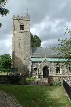 Church of St Andrew |
| Abbey Farmhouse | Old Buckenham | Farmhouse | c.1550–60 | 16 July 1958 | TM0710492556 52°29′30″N 1°02′57″E |
1169388 |  Abbey Farmhouse |
| Old Buckenham Windmill | Old Buckenham | Windmill | 1818 | 21 July 1951 | TM0623590987 52°28′40″N 1°02′07″E |
1342467 | |
| Church of St. John Evangelist | Ovington | Parish church | 12th century | 16 July 1958 | TF9254402594 52°35′13″N 0°50′27″E |
1076798 |  Church of St. John Evangelist |
| Church of the Immaculate Conception of the Blessed Virgin Mary and St Margaret, Oxburgh Hall | Oxburgh Hall Park, Oxborough | Roman Catholic chapel | 1838 | 23 June 1960 | TF7414701269 52°34′53″N 0°34′08″E |
1342587 |  Church of the Immaculate Conception of the Blessed Virgin Mary and St Margaret, Oxburgh Hall |
| Park boundary wall including tower and gateway, Oxburgh Hall | Oxburgh Hall Park, Oxborough | Tower | 15th century | 23 October 1985 | TF7398601224 52°34′52″N 0°33′59″E |
1306374 |  Park boundary wall including tower and gateway, Oxburgh Hall |
| Church of All Saints, including tower | Hargham, Quidenham | Church | 14th century | 16 July 1958 | TM0199291350 52°28′58″N 0°58′24″E |
1077512 |  Church of All Saints, including tower |
| Church of St Andrew | Quidenham | Parish church | Late 11th century | 16 July 1958 | TM0284087675 52°26′58″N 0°59′01″E |
1169567 |  Church of St Andrew |
| Church of St Mary | Eccles, Quidenham | Parish church | 12th century | 16 July 1958 | TM0191389356 52°27′53″N 0°58′15″E |
1077510 |  Church of St Mary |
| Wilby Hall | Wilby, Quidenham | Country house | Late 16th century | 9 February 1984 | TM0327390555 52°28′30″N 0°59′30″E |
1077519 |  Wilby Hall |
| Church of St Peter | Riddlesworth | Parish church | Early 14th century | 16 July 1958 | TL9666681284 52°23′39″N 0°53′20″E |
1077393 |  Church of St Peter |
| Dovecote to Rougham Hall | Rougham | Dovecote | c.1690 | 4 December 1951 | TF8298320606 52°45′07″N 0°42′35″E |
1342500 | |
| Church of St Botolph | Stow Bedon | Parish church | 12th century | 21 July 1958 | TL9614695574 52°31′22″N 0°53′23″E |
1077585 |  Church of St Botolph |
| Manor House including attached service range to east | Swaffham | House | c.1740 | 17 January 1973 | TF8241909030 52°38′54″N 0°41′42″E |
1269575 | |
| Oakleigh House | Swaffham | House | Early 17th century | 10 January 1951 | TF8182608997 52°38′54″N 0°41′11″E |
1269627 |  Oakleigh House |
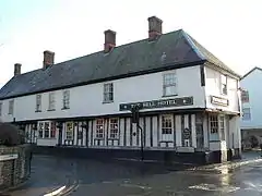
| Bell Hotel | Thetford | Jettied house | Mid-15th century | 3 April 1951 | TL8692483124 52°24′51″N 0°44′49″E |
1195935 | |
| Church of St Cuthbert | Thetford | Parish church | Early 13th century | 3 April 1951 | TL8712083067 52°24′49″N 0°45′00″E |
1207726 |  Church of St Cuthbert |
| Church of St Mary the Less | Thetford | Parish church | 11th century | 3 April 1951 | TL8678982822 52°24′41″N 0°44′42″E |
1297899 |  Church of St Mary the Less |
| Church of St Peter | Thetford | Parish church | 14th century | 3 April 1951 | TL8692783176 52°24′53″N 0°44′50″E |
1219326 |  Church of St Peter |
| Fulmerston's Almshouses | Thetford | Almshouse | 1610 | 3 April 1951 | TL8682282858 52°24′43″N 0°44′43″E |
1279468 | |
| Nunnery Place ruin approximately 10 metres south-east of the Nunnery | Nunnery Place, Thetford | Benedictine nunnery | c.1160–1540 | 3 April 1951 | TL8731682222 52°24′21″N 0°45′08″E |
1195915 |  Nunnery Place ruin approximately 10 metres south-east of the Nunnery |
| Roman Catholic Church of St Mary | Thetford | Roman Catholic church | 1826 | 3 April 1951 | TL8666182844 52°24′42″N 0°44′35″E |
1207963 | |
| The Nunnery | Nunnery Place, Thetford | House | Early 17th century | 3 April 1951 | TL8730282260 52°24′23″N 0°45′08″E |
1208030 |  The Nunnery |
| Thetford Warren Lodge | Thetford | Gamekeeper's lodge | Early 15th century | 10 March 1971 | TL8392984066 52°25′25″N 0°42′13″E |
1297876 |  Thetford Warren Lodge |
| 3 and 5 Castle Street | Thetford | House | Late 15th century | 3 April 1951 | TL8722483061 52°24′49″N 0°45′05″E |
1207558 | |
| 3 and 4 Market Place | Thetford | Apartment | 16th century | 3 April 1951 | TL8718883087 52°24′49″N 0°45′03″E |
1207841 | |
| College Farmhouse | Thompson | House | 1350 | 21 July 1951 | TL9323296594 52°31′59″N 0°50′51″E |
1076807 | _-_geograph.org.uk_-_1752582.jpg.webp) College Farmhouse |
| Church of St Andrew | Tottington | Parish church | 14th century | 16 July 1958 | TL8939795521 52°31′29″N 0°47′25″E |
1342814 |  Church of St Andrew |
| Church of St Nicholas | Twyford | Parish church | 14th century | 30 May 1960 | TG0167724610 52°46′53″N 0°59′20″E |
1170307 |  Church of St Nicholas |
| Church of St. Mary | Watton | Parish church | 12th century | 16 July 1958 | TF9213500943 52°34′20″N 0°50′02″E |
1153046 | 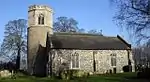 Church of St. Mary |
| Church of All Saints | Weasenham All Saints | Parish church | 14th century, restored 1905–06 | 30 May 1960 | TF8508021612 52°45′37″N 0°44′29″E |
1306499 |  Church of All Saints |
| Church of St Peter | Weasenham St. Peter | Parish church | 13th century | 30 May 1960 | TF8561822355 52°46′01″N 0°44′59″E |
1169531 | 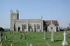 Church of St Peter |
| Church of St Mary | Weeting-with-Broomhill | Parish church | 14th century | 23 June 1960 | TL7766989192 52°28′18″N 0°36′52″E |
1172178 |  Church of St Mary |
| Church of St Andrew | Wellingham | Parish church | Late 13th century and later | 30 May 1960 | TF8709822257 52°45′56″N 0°46′18″E |
1077456 | 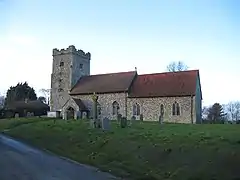 Church of St Andrew |
| Church of St Peter and Paul | Wendling | Parish church | 14th century, Norman fragments | 30 May 1960 | TF9313413134 52°40′53″N 0°51′20″E |
1077339 | 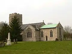 Church of St Peter and Paul |
| Church of St Andrew | Westfield, Whinburgh and Westfield | Parish church | 14th century | 30 May 1960 | TF9929709919 52°39′01″N 0°56′41″E |
1077294 |  Church of St Andrew |
| Old Hall | Whinburgh and Westfield | Farmhouse | c.1600 | 4 December 1951 | TG0150807909 52°37′53″N 0°58′34″E |
1152045 | |
| Church of St Mary | Whissonsett | Parish church | Early 14th century and later | 30 May 1960 | TF9191923345 52°46′25″N 0°50′37″E |
1077436 |  Church of St Mary |
| Church of St Andrew | Illington, Wretham | Parish church | Early 15th century | 16 July 1958 | TL9481189994 52°28′23″N 0°52′01″E |
1170666 |  Church of St Andrew |
| Church of St Ethelbert | Wretham | Parish church | 12th century | 16 July 1958 | TL9150590632 52°28′48″N 0°49′07″E |
1170650 |  Church of St Ethelbert |
| Holland's Hall | Bakerfield Green, Yaxham | Farmhouse | Late 16th century | 4 December 1951 | TG0289109506 52°38′43″N 0°59′51″E |
1152070 | |

Notes
- The date given is the date used by Historic England as significant for the initial building or that of an important part in the structure's description.
- Sometimes known as OSGB36, the grid reference is based on the British national grid reference system used by the Ordnance Survey.
- The "List Entry Number" is a unique number assigned to each listed building and scheduled monument by Historic England.
External links
This article is issued from Wikipedia. The text is licensed under Creative Commons - Attribution - Sharealike. Additional terms may apply for the media files.