Grade II* listed buildings in Cheltenham
There are over 20,000 Grade II* listed buildings in England. This page is a list of these buildings in the district of Cheltenham in Gloucestershire.
List of buildings
| Name | Location | Type | Completed [note 1] | Date designated | Grid ref.[note 2] Geo-coordinates |
Entry number [note 3] | Image |
|---|---|---|---|---|---|---|---|
| Charlton Park (St Edwards School Main Building) | Charlton Kings | Country house | c.1720 | 22 April 1950 | SO9593820805 51°53′09″N 2°03′38″W |
1386593 | 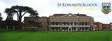 Charlton Park (St Edwards School Main Building) |
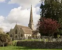
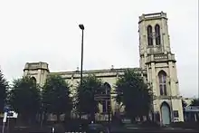
| Church of St Mary | Charlton Kings | Parish church | Norman; c.1190 | 22 April 1950 | SO9645020441 51°52′57″N 2°03′11″W |
1386562 | 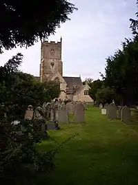 Church of St Mary |
| Churchyard cross approximately 15 metres north-west of west door of Church of St Mary | Charlton Kings | Cross | 15th century | 24 April 1950 | SO9642620458 51°52′58″N 2°03′12″W |
1386564 | 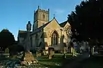 Churchyard cross approximately 15 metres north-west of west door of Church of St Mary |
| King's House | Charlton Kings | House | c.1603 | 22 April 1950 | SO9660820724 51°53′06″N 2°03′02″W |
1386658 |  |
| South West Regency (administration) Block to St Edwards Middle School | Charlton Kings | Villa | c.1832 | 8 February 1983 | SO9653621465 51°53′30″N 2°03′06″W |
1386540 | |
| The Court House | Charlton Kings | House | 1614 | 23 March 1982 | SO9602420544 51°53′00″N 2°03′33″W |
1386653 | |
| Church of St Peter | Leckhampton | Church | 12th-century origins | 4 July 1960 | SO9429619403 51°52′23″N 2°05′03″W |
1340121 | |
| Leckhampton Court with wall and gate piers | Leckhampton | House | 14th century | 4 July 1960 | SO9449919338 51°52′21″N 2°04′53″W |
1091754 | 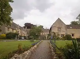 Leckhampton Court with wall and gate piers |
| Church of St Mary | Prestbury | Anglican church | 13th century | 4 July 1960 | SO9699223992 51°54′52″N 2°02′43″W |
1153687 | 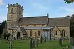 Church of St Mary |
| Francis Kemmet(t) Monument in the churchyard of the Church of St Mary circa 3 metres north of north aisle | Prestbury | Chest tomb | 1716 | 25 February 1987 | SO9698724004 51°54′52″N 2°02′43″W |
1153742 | _monument.jpg.webp) Francis Kemmet(t) Monument in the churchyard of the Church of St Mary circa 3 metres north of north aisle |
| Church of St Lawrence | Swindon Village | Anglican church | 12th century | 4 July 1960 | SO9346324886 51°55′21″N 2°05′47″W |
1091887 | 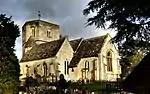 Church of St Lawrence |
| Alma House and walls and piers adjoining | Cheltenham | Villa | 1838 | 12 March 1955 | SO9484622120 51°53′51″N 2°04′35″W |
1387813 | 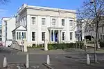 Alma House and walls and piers adjoining |
| Bayshill House and Lingwood House | Cheltenham | Villa | c.1839–42 | 12 March 1955 | SO9446522184 51°53′53″N 2°04′55″W |
1386735 | |
| Bayshill Lodge (1, 2 and 3), ballroom mews arch to north-west, and Nos 1–19 Rotunda Terrace | Cheltenham | House | 1844/1851 | 12 March 1955 | SO9439721891 51°53′44″N 2°04′58″W |
1387125 | 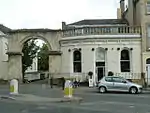 Bayshill Lodge (1, 2 and 3), ballroom mews arch to north-west, and Nos 1–19 Rotunda Terrace |
| Brandon House | Cheltenham | Villa | 1834–39 | 12 March 1955 | SO9438821087 51°53′18″N 2°04′59″W |
1387401 | .jpg.webp) Brandon House |
| Cheltenham College (main block to road with Dining Hall and Chapel) | Cheltenham | Public school | 1843 | 12 March 1955 | SO9486121501 51°53′31″N 2°04′34″W |
1386726 | 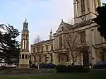 Cheltenham College (main block to road with Dining Hall and Chapel) |
| Christ Church and adjacent Church Hall | Cheltenham | Church | 1837–40 | 12 March 1955 | SO9399622280 51°53′57″N 2°05′19″W |
1103838 | 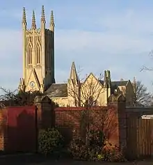 Christ Church and adjacent Church Hall |
| Church of St Gregory | Cheltenham | Church | 1859 | 5 May 1972 | SO9457022558 51°54′06″N 2°04′49″W |
1387870 | |
| Church of St Mary with St Matthew | Cheltenham | Church | 1877–79 | 14 December 1983 | SO9469822503 51°54′04″N 2°04′42″W |
1386868 | 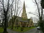 Church of St Mary with St Matthew |
| Church of St Paul | Cheltenham | Church | 1831 | 12 March 1955 | SO9478823169 51°54′25″N 2°04′38″W |
1387184 | |
| Church of St Peter | Cheltenham | Parish church | 1847–48 | 12 March 1955 | SO9385523361 51°54′31″N 2°05′27″W |
1388006 | 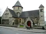 Church of St Peter |
| Church of St Philip and St James with attached walls and gates | Cheltenham | Church | 1879–82 | 14 December 1983 | SO9444221120 51°53′19″N 2°04′56″W |
1245772 | 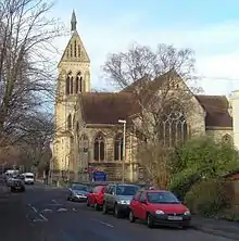 Church of St Philip and St James with attached walls and gates |
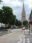
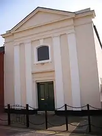
| Church of St Stephen | Tivoli | Church | 1873–74 | 14 December 1983 | SO9388521380 51°53′27″N 2°05′25″W |
1387915 | |
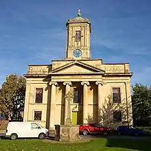
| Church of the Holy Trinity | Cheltenham | Church | 1820–23 | 12 March 1955 | SO9517822772 51°54′12″N 2°04′17″W |
1387583 | |
| Claremont Lodge | Cheltenham | Apartment | c.1800–10 | 12 March 1955 | SO9475321845 51°53′42″N 2°04′40″W |
1387123 |  Claremont Lodge |
| Clarence House and attached railings | Cheltenham | Villa | 1830–34 | 12 March 1955 | SO9456622046 51°53′49″N 2°04′49″W |
1387687 | |
| Evelyn Terrace, Lansdown Terrace, Evelyn Court, Regan House, attached railings and mews archway | Cheltenham | Apartment | c.1832 | 12 March 1955 | SO9413522011 51°53′48″N 2°05′12″W |
1103835 | .jpg.webp) Evelyn Terrace, Lansdown Terrace, Evelyn Court, Regan House, attached railings and mews archway |
| Francis Close College: Old Practising School | Cheltenham | School | 1854–58 | 5 May 1972 | SO9462423128 51°54′24″N 2°04′46″W |
1387896 |  Francis Close College: Old Practising School |
| General Hospital (central block) and attached railings | Cheltenham | Hospital | 1848 | 5 May 1972 | SO9513721512 51°53′32″N 2°04′19″W |
1387935 |  General Hospital (central block) and attached railings |
| George Hotel (nos 41–49) and attached railings to Nos 29–39 and 43–49 | Cheltenham | House | c.1837–45 | 12 March 1955 | SO9449722299 51°53′57″N 2°04′53″W |
1387846 |  George Hotel (nos 41–49) and attached railings to Nos 29–39 and 43–49 |
| Gloucester Lodge (No 129) Sherborne Lodge (No 131) gate piers and gates | Cheltenham | Villa | 1833–34 | 12 March 1955 | SO9458422070 51°53′50″N 2°04′48″W |
1387686 | |
| Lansdown Road (terrace) and attached area railings with wall at left | Cheltenham | Apartment | 1825–35 | 5 May 1972 | SO9406521762 51°53′40″N 2°05′16″W |
1245385 | |
| Lansdown Place (terrace) and Montpellier Court and attached railings | Cheltenham | Apartment | 1825–35 | 5 May 1972 | SO9420521785 51°53′41″N 2°05′08″W |
1245384 | |
| Lypiatt Terrace and balustrades; area railings to Nos 3 and 6 | Cheltenham | Terraced house | c.1847 | 5 May 1972 | SO9422821677 51°53′37″N 2°05′07″W |
1245263 | |
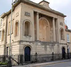
| Masonic Hall | Cheltenham | Freemasons hall | 1818–23 | 12 March 1955 | SO9505222602 51°54′07″N 2°04′24″W |
1387563 | |
| Montpellier Arcade and attached gates | Cheltenham | Apartment | 1831–32 | 12 March 1955 | SO9450921976 51°53′47″N 2°04′52″W |
1245181 | |
| No 81, Montpellier Crescent and attached railings | Cheltenham | House | c.1825 | 5 May 1972 | SO9468521652 51°53′36″N 2°04′43″W |
1387337 | |
| Nos 1–13, Imperial Square with attached area railings throughout and pier to No 1 | Cheltenham | Terrace | c.1834 | 12 March 1955 | SO9479422118 51°53′51″N 2°04′37″W |
1104370 | .jpg.webp) Nos 1–13, Imperial Square with attached area railings throughout and pier to No 1 |
| Nos 14–34, Imperial Square and attached railings | Cheltenham | Terrace | c.1834 | 12 March 1955 | SO9476421977 51°53′47″N 2°04′39″W |
1104372 | |
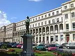
| Nos 1–18, Royal Crescent and attached area railings | Cheltenham | Apartment | c.1806–10 | 12 March 1955 | SO9465322388 51°54′00″N 2°04′45″W |
1387817 | 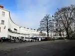 Nos 1–18, Royal Crescent and attached area railings |
| Nos 1–23, Lansdown Parade and attached area railings | Cheltenham | Terrace | 1838–41 | 12 March 1955 | SO9384921828 51°53′42″N 2°05′27″W |
1333176 | .jpg.webp) Nos 1–23, Lansdown Parade and attached area railings |
| Nos 2–12, Lansdown Crescent and attached railings | Cheltenham | Apartment | Completed by c.1850 | 12 March 1955 | SO9418621856 51°53′43″N 2°05′09″W |
1333172 | |
| Nos 13 to 47, Lansdown Crescent and attached area railings | Cheltenham | Apartment | 1831–38 | 12 March 1955 | SO9398921829 51°53′42″N 2°05′20″W |
1333173 | .jpg.webp) Nos 13 to 47, Lansdown Crescent and attached area railings |
| Nos 1–23, Montpellier Walk and Hanover House (National Westminster Bank) | Cheltenham | Apartment | c.1836–45 | 12 March 1955 | SO9445321911 51°53′45″N 2°04′55″W |
1387359 | 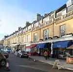 Nos 1–23, Montpellier Walk and Hanover House (National Westminster Bank) |
| Nos 47 to 83, Promenade and attached railings with low walls and end piers to Nos 71 and 73 | Cheltenham | House | 19th century | 12 March 1955 | SO9473722305 51°53′57″N 2°04′40″W |
1387631 | |
| Numbers 99–119, Promenade and attached railings | Cheltenham | Apartment | By 1834 | 12 March 1955 | SO9466822194 51°53′54″N 2°04′44″W |
1387670 | |
| Nos 121 and 123, Promenade and attached railings | Cheltenham | Villa | 1834–40 | 12 March 1955 | SO9461722115 51°53′51″N 2°04′47″W |
1387684 | |
| Nos 125 and 127, Promenade and attached railings | Cheltenham | Villa | 1834–40 | 12 March 1955 | SO9460122093 51°53′50″N 2°04′48″W |
1387685 | |
| Nos 18–24, Priory Parade and attached railings | Cheltenham | Apartments | c.1820–30 | 12 March 1955 | SO9545721968 51°53′46″N 2°04′03″W |
1104398 | .jpg.webp) Nos 18–24, Priory Parade and attached railings |
| Oriel Terrace Nos 1–4 with mews arch and attached railings | Cheltenham | Terrace | 1826 | 12 March 1955 | SO9496022024 51°53′48″N 2°04′29″W |
1387383 | |
| Oxford Parade and attached railings | Cheltenham | Apartment | c.1780–1820 | 12 March 1955 | SO9548321947 51°53′46″N 2°04′01″W |
1104401 | |
| Oxford Parade and attached railings | Cheltenham | Apartment | 1816–17 | 12 March 1955 | SO9552121914 51°53′45″N 2°03′59″W |
1103817 | |
| Parish Centre for St Philip and St James | Cheltenham | Parish hall | 1830 | 12 March 1965 | SO9458121608 51°53′35″N 2°04′49″W |
1387994 | 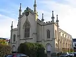 Parish Centre for St Philip and St James |
| Queens Hotel | Cheltenham | Hotel | 1838 | 12 March 1955 | SO9457421980 51°53′47″N 2°04′49″W |
1387698 | 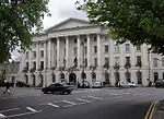 Queens Hotel |
| Nos 1–6, St Margaret's Terrace and attached area railings | Cheltenham | Apartment | 1820–25 | 12 March 1955 | SO9503522734 51°54′11″N 2°04′25″W |
1387881 | |
| St Paul's College Cheltenham and Gloucester College of Higher Education | Cheltenham | Further education college | 1849 | 12 March 1955 | SO9462623044 51°54′21″N 2°04′46″W |
1387995 | 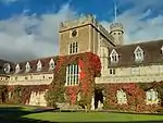 St Paul's College Cheltenham and Gloucester College of Higher Education |
| Synagogue | Cheltenham | Synagogue | 1837–39 | 5 May 1972 | SO9455422416 51°54′01″N 2°04′50″W |
1387877 | |
| Trident House (No 27a) and attached railings to Nos 15–21 and 27 | Cheltenham | Terrace | 1837–40 | 12 March 1955 | SO9458722269 51°53′56″N 2°04′48″W |
1387845 | |
| Nos 1–2 Suffolk Square, No 1 Willoughby and attached area railings to Nos 2–12 | Cheltenham | Apartments | 1832–48 | 12 March 1955 | SO9451221657 51°53′36″N 2°04′52″W |
1387971 | |
Notes
- The date given is the date used by Historic England as significant for the initial building or that of an important part in the structure's description.
- Sometimes known as OSGB36, the grid reference is based on the British national grid reference system used by the Ordnance Survey.
- The "List Entry Number" is a unique number assigned to each listed building and scheduled monument by Historic England.
External links
This article is issued from Wikipedia. The text is licensed under Creative Commons - Attribution - Sharealike. Additional terms may apply for the media files.